After a torrid weekend—Sunday’s high temperature of 97 degrees broke the all-time record for September 24 of 95 degrees, which had been set just the previous year—some relief is on the way. A weak front will slowly push southward into the city today. This will bring widespread showers and thunderstorms, with a slight chance of hail and damaging winds. In the front’s wake we’ll see slightly cooler days and nights, with drier air making for somewhat more pleasant mornings and evenings.
Monday
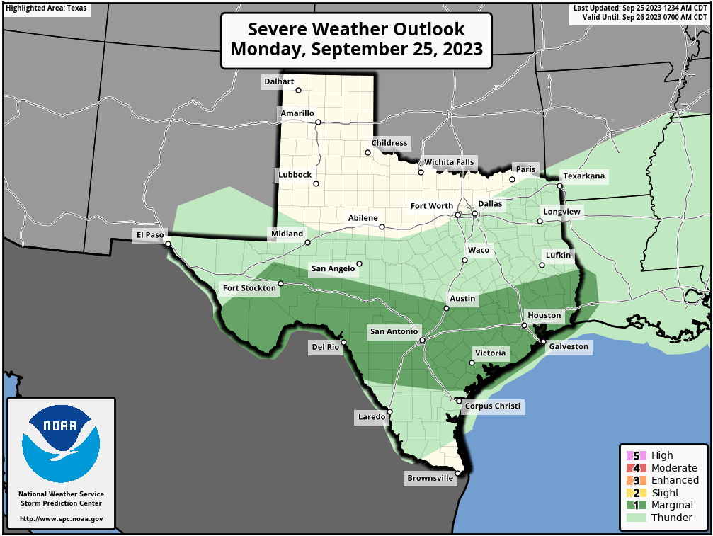
As of 6:30 am CT we’re seeing storms fire up near Cypress and Huntsville, and the focus of activity during the morning hours will generally be along and north of Interstate 10. This afternoon and evening the better chances for rain will shift further south and closer to the coast. Overall rain chances are probably about 70 percent, with amounts varying widely.
Some areas will see a tenth or two of an inch, whereas some locations beneath stronger thunderstorms may pick up 1 to 2 inches of rainfall. Stronger thunderstorms will also carry the potential for severe weather, like hail and damaging winds. However, the dynamics are not super supportive for severe weather, so while it’s a possibility, I don’t anticipate bedlam out there.
In terms of temperatures, they’re going to be dependent on cloud coverage and storms this afternoon. Most areas will probably reach the low 90s, however. Overnight lows will drop into the mid-70s for much of the area, with a chance of showers lingering south of Interstate 10.
Tuesday
The aforementioned front is essentially going to stall out along the coast. For areas south of Interstate 10, then, a decent chance of showers will persist on Tuesday. Further inland, however, rain chances will likely be only 10 or 20 percent. Expect daytime highs in the low 90s, with partly sunny skies, and light northeast winds. Lows on Tuesday night should drop into the mid-70s. The air will be slightly (but only very slightly) drier than it has been.
Wednesday, Thursday, and Friday
The latter half of the week should see high temperatures generally in the low-90s, with partly to mostly sunny skies. Rain chances will probably drop back to 20 percent, again, with this higher likelihood nearer to the coast. Nights will generally fall into the mid-70s.
Saturday and Sunday
The overall atmospheric setup favors a slightly drier flow of air this weekend, and with lower dewpoints we’ll see a couple of effects. First of all, rain chances will be basically zero, with sunny skies. Highs will likely reach the mid-90s, but with the drier air we’ll also cool off more quickly in the evenings, so it should feel a little bit nicer outside in those instances.
Next week
This pattern should more or less continue into next week, however the trend may be toward a bit cooler conditions by the middle of next week. It’s possible that we could see something of a stronger front in about 10 to 14 days. There are hints of it in the models and the overall pattern. But the signal is not particularly strong, so my confidence is low. For now, enjoy your extended summer, Houston.


Models hint ar a widespread “blast” front around Oct 10-14. Right now the front looks to pack a wimpy punch towards the Houston area, unfortunately. Hopefully things change, no jinx.
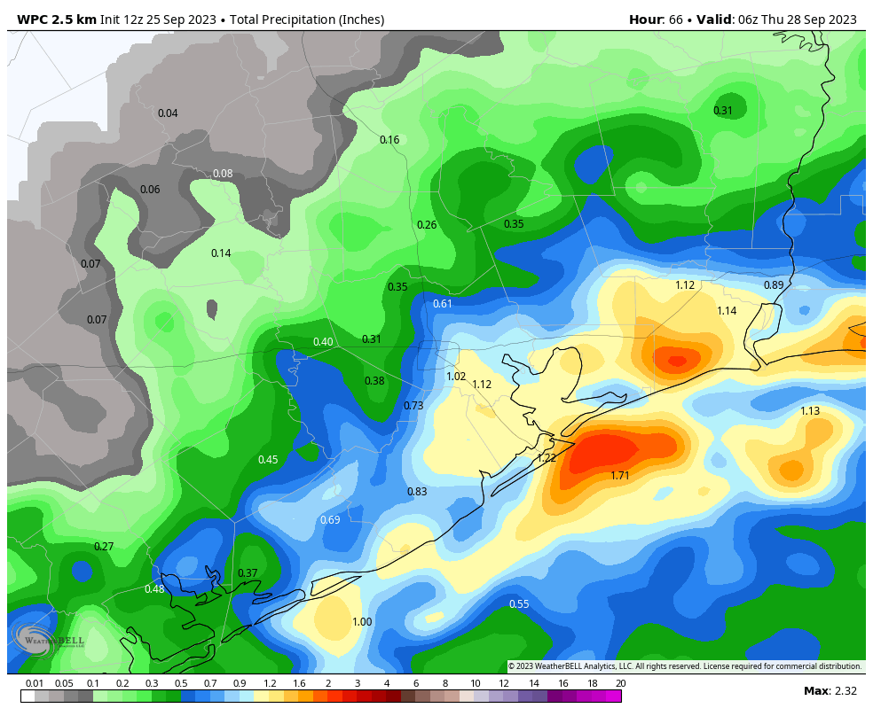
Dang, that’s a big gradient in the rain accumulation forecast for downtown. Basically, anybody’s guess?
I am emphatically NOT enjoying this extended summer.
Its been raining at a good clip down here by Hobby airport. Thank GOD! My pecan trees sure need it. Hoping this front stalls out over us and keeps raining all day.
Nothing here in Magnolia and won’t be.
Just look at the National Weather Radar – that’s a good resource – no predictions, just real time factual movement. It’s all mostly north and east, and continuing to move that direction. Minor wetness hovering h-town proper (yawn).
Same here. We live out in Santa Fe, just two miles west of I-45, down 1764 which is also two miles from the old defunked dog track. I’ve lived out here now for over 40 years and usually expect to get less rain at our place during any rain event. Anway, due to last Friday’s forecast, we weren’t expecting any rain that day. But later that afternoon my wife said while she was up in the Friendswood area, it rained so hard that some of the streets began to flood. What’s up with that?
Interesting interpretation of weather forecasting ya got there.
Happy Fall Everyone,
Stay safe and have a great week.
Thanks again for this very informative site
Go home, summer, you’re drunk.
🤣😂🤣!!
It’s like Groundhog Day, except in Houston it’s if the raccoon pokes his head out of your attic and sees a possum on the fence, we get another six weeks of summer. Also there’s no set date, it’s just a rolling renewal
And, as usual, no rain in Clayton. Trees are really suffering, neighbor already lost a Pecan tree.
Well we’ve had .03″ here in the Champions area. There was a bit more to our west. If this is all we get then it’s very disappointing and I will have to run the sprinkler this evening. Best of luck to y’all for more rain.
90 degrees for Christmas anyone?
I counted it up and it has been 108 grueling days (since June 8th) of relentless drought & heat since we last received a 1.00” rain here in Oak Forest area. That’s 3 1/2months!!! How can trees and bushes live for 3+ months without rainfall? I imagine We will need at least 5-6 inches of rain to recharge the subsoil.
I live in Timbergrove. Same here.
Slight drizzle and a smear of rain in Westchase.
These forecasts of rain is like someone offering a kid an ice lolly then pulls it away when the child reaches out for it. Eventually the child gets wise and doesn’t expect anything.
We’re still on the periphery of a mid level atmospheric Texas ridge (5910 meters in late September!) to the Southwest. The pressure gradient encompasses here all the way to NOLA. No fronts can get south and stay together. The rain line up by College Station just disappeared off the scope. I can’t wait until a front does come thru so I can see on the display what that looks like. Never gave it much thought before. But that won’t be for 3 weeks at least. I am very disappointed like y’all but per the forecast we were warned not to expect anything.
Wondering what resources you use to find this information. I know we were promised a lookback posting on this summer, but I really would like to hear more scientifically about why this particular summer is so much worse compared to the averages. Maybe I should go back to school and get a meteorology degree 🙁
As I shop around for weather forecasts, came across a low chance of tropical development in the Gulf. Its probably hyped up, but I’m desperate I tell u!
“Ah, September! You are the doorway to the season that awakens my soul.” – Peggy Toney Horton
The mood is somber so it’s time for a little hope…
On this date in 1976 the high was a warm 88 but the low was a delightfully brisk 64. If it happened then it can happen again. The fronts are on the way…
Last year we actually had a front blow through on the 26 which gave us highs in the mid to upper 80s and wonderful lows in the upper 50s for the final 4 days of September 2022. It’s amazing the sharp variations that can occur year to year.
I’m glad I’m not the only one who notices this. None of the “weather experts” ever address it but it’s real. My thrust is there’s too much heat coming up from all the concrete and it pushes the rain away.
Need convection to get rain. Typically there has been a pressure cap several thousand feet up over this area which stops the convection. When was the last time you saw a tall rising cumulonimbus cloud? I can’t remember one here. But you must have them to get a good soaking rain. Scattered showers ain’t in it.
I’m with you on this DJ. I also can’t remember the last time I saw a tall rising cumulonimbus cloud and we live out here in Santa Fe. Not only that but it’s now Monday evening and all we got out here today was distant thunder. It’s not easy keeping everything alive here on several acres of farmland.
More hype about rain that doesn’t pan out. Who needs weather predictions when you can just look outside and see what’s actually happening? Beyond frustrating.
We’re in Baytown, south of I-10, just south of new 146 and between old 146 and Cedar Bayou. Just as dusk fell today, the skies opened up for over an hour and we got over 3 inches of rain!!!!! So, so thankful!!!