As the tropics heat up all around Texas—with Tropical Storm Fernand moving into Mexico and Hurricane Dorian threatening the southeastern United States—the big local concern is actually an emerging drought. With extremely hot and sunny weather forecast for awhile in Houston, a moderate drought could return to the region for the first time in nearly three years. We’re going to discuss that at the end of today’s post.
Wednesday through Friday
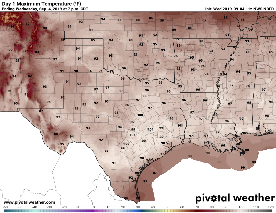
The forecast is more or less the same for the rest of the work week, with building high pressure over the state of Texas. We are going to see high temperatures near or at 100 degrees, lows around 80 degrees, and rain chances of effectively zero percent. The air mass will be a little drier than normal for “summer,” so the heat index won’t be quite as high as it was in August, but it’s still going to be really, really hot. We probably will set some daily high temperature records this week.
Saturday and Sunday
At this point, the weekend should bring more of the same. Make your beach or other outdoor plans with confidence.
Next week
High pressure should finally back off early next week, allowing for more moisture to work its way inland from the Gulf of Mexico. This should lead to the development of more clouds, along with some decent rain chances. But don’t expect too much. The global model ensembles, on average, forecast about one-half inch of rain for all of next week. Temperatures should drop back into the low- or mid-90s. Alas, there remains nary a whiff of a cold front in the models, sorry.

Drought
The western half of the Houston metro area, along with a chunk of the region northeast of Houston, have seen soils turn “abnormally dry,” which is the first step toward a moderate drought.
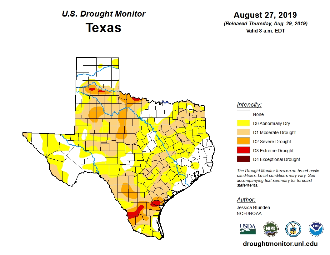
With almost a week of very hot and likely very dry weather ahead of us, we can probably expect the areas in yellow on the map above to turn into a moderate drought, and the abnormally dry areas to expand. This would be notable, because I do not believe any part of Harris County has fallen under “moderate drought” conditions since November, 2016.
The dry weather has really been amplified during the last month. If we look at a “percentage of normal” rainfall map for Texas for the last 30 days, we can see that much of the area received 50 percent or less of normal rainfall.
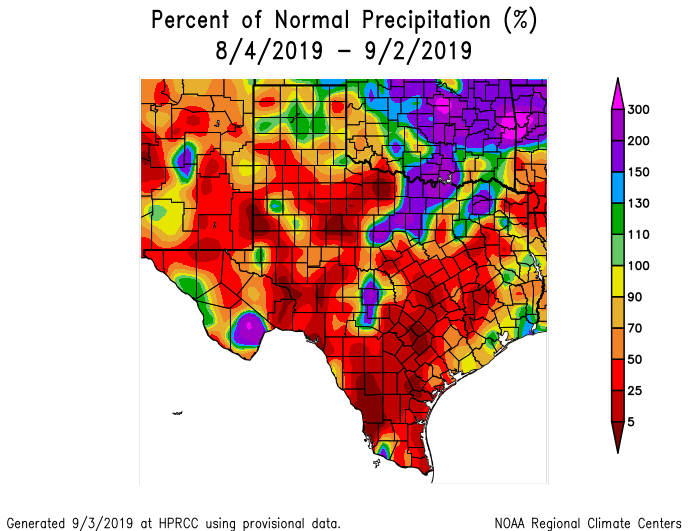
Only a small area of southeastern Harris, and northern Galveston and Brazoria counties has gotten above normal rains. If you live there, consider yourself lucky.
Oh, this sucks. Come on, October.
Now, the fine art of watering the grass just enough to keep it alive without having to cut for several weeks…,
when did we officially move out of drought conditions after the nasty summer of 2011?
Hurricane Harvey??
Harvey??
I’d have to guess the 2015 Memorial Day flood.
Thanks guys. My old home in Denver set a September all time high by hitting the century mark. This high pressure ridge is not what we need. Right now we’re in the “abnormally dry” category according to NOAA. Guessing that might bounce up a category or two.
Just wanted to thank both of you for your constant updates on Dorian. They were greatly appreciated by myself and quite a few friends/family. Excellent job guys. I’m sure you could probably use a little break from the tropics but I’m guessing you’re not thinking. People like you…weather runs through your veins. Thanks again.
Does this mean we’re in for a big rain event later this year?
Hope so. Here in Cypress we have had only 12.5″ of rain this year…about 19″ below average for this time of the year.
I think it is still “summer” ?
Reminds me of Hurricane Ike. Had a big old drought, then all the trees snapped like toothpicks from the wind.
High pressure system isn’t great for drought and lack of rain, but does this thing “protect” from hurricanes/tropical moisture. For example keeping Ferdinand south of us. I’ll take a drought over a major hurricane any day if the week.