Rumors of cold weather have been circulating for a little while now. As I write this, we’re about 36 hours away from “go” time. The details…
TODAY
One more day of balmy weather will greet us today. We hit 79° yesterday at IAH Airport, but we’ll likely shave three to five degrees off that today. Expect low to mid 70s, with another round of sunshine.
SATURDAY
Our cold front will arrive on Saturday, likely during the late morning or early afternoon. Conveniently, the timing of the temperature drop may be similar to what we experienced on Tuesday. Some differences between Tuesday and what will happen Saturday:
1.) We will have much less rain. While I wouldn’t yet rule out a thunderstorm or some scattered downpours as the front moves through, it will be less impressive than what we saw Tuesday. The best chance of thunder would be south of Houston. It should be emphasized: This is mostly a morning deal. If you have afternoon plans, you’ll probably see improvement, albeit a bit chilly.
2.) Rather than a quick 15-20 degree plunge 20-30 minutes after the front passes through like we saw Tuesday, we’ll likely see temperatures drop slowly and steadily Saturday afternoon, from the mid-60s in the morning into the mid-50s by late afternoon or early evening.
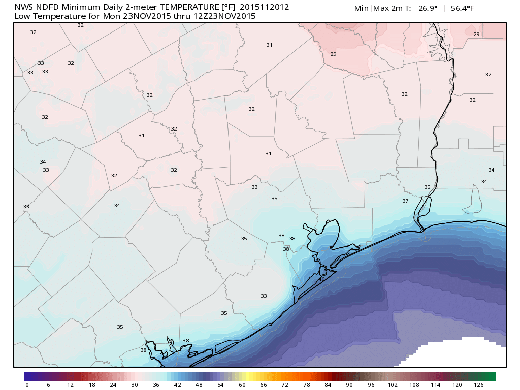
SUNDAY and MONDAY
Expect the word “frost” to be used a lot Sunday and Monday mornings. Sunday morning likely sees temperatures ease back into the upper-30s to low-40s in Houston. In addition to that, there will be a steady 10-15 mph wind. It will feel mighty cold Sunday. High temperatures probably don’t get past the mid-50s either on Sunday afternoon.
With lighter winds Sunday night and Monday morning, the temperature should be able to free fall. While I *highly* doubt we see freezing temperatures in the City of Houston or at the airport, we will likely see mid-30s over a good chunk of the area. Go to some of the more rural, cooler spots west or north of Houston though, and there’s a definite chance you’ll see temperatures around freezing. Prepare plants in those areas accordingly.
THANKSGIVING
We are starting to gain a *little* clarity on what happens over Thanksgiving. There’s good news and bad news. The good news is that I expect Thanksgiving Day to be a pretty quiet one. We will see much warmer temperatures return (mid to upper-70s). We may see clouds or a localized shower, but nothing serious. So Thanksgiving itself looks mostly fine (as does Wednesday for those travelling).
Now, the bad news: A more significant storm is likely to impact us by Friday or Saturday, and that could drag in some colder temperatures again after it passes. There are still a number of specifics (some very important ones) regarding this system that are very much in flux and TBD as of now, so I don’t want to go crazy on details just yet. But, more unsettled weather is likely next weekend, possibly as soon as Friday or possibly holding off until Saturday or even Sunday. There are many moving parts, so if you have plans next weekend post-Thanksgiving, stay tuned.
Posted at 6:40 a.m. CT
i miss your haiku 🙂
Maybe I’ll bring those back for Mondays!
So, do I wear sweats and my hoodie or capri’s and short sleeves when I board my cruise ship Saturday morning after Thanksgiving? And, what does it look like for the Cayman Islands? Just got two new bathing suits…… 🙂
Hmmm…we had planned on Sunday for the Renfest. Maybe I should think about Saturday instead. I like the cool weather, but my wife is more of a warm-blooded creature. 🙂
Saturday will be wet. Definitely go Sunday.