Continuing our theme of giving you the latest forecast information, here’s an early afternoon update.
Now
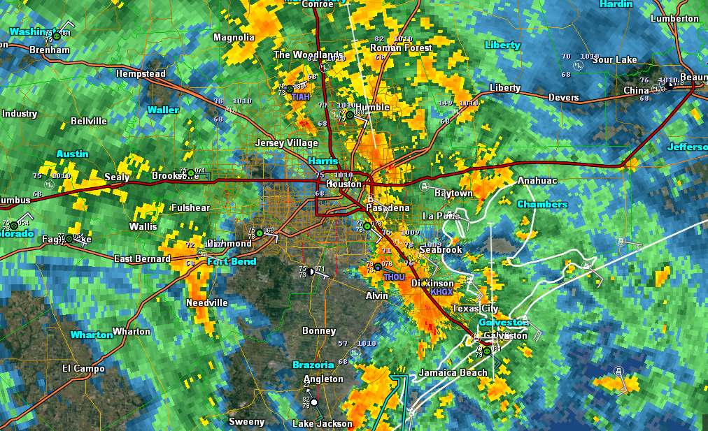
Some good news for some folks. Dry air has punched in west of I-45 as of 12:30, and in some areas, we’re getting a nice dry period. Other areas are still seeing rains, but they’re falling at manageable rates. We continue to see isolated tornado warnings pop up all over the area.
Rest of Today
Looking at high-resolution weather models, I think we’re going to see this pattern continue. Occasional drying moves around the area, with pockets of heavier rain at times. Some places may see 1-3″ in an hour. This will limit improvement, but outside of areas where runoff from last night is still flowing through the system, it shouldn’t make things terribly worse. Not ideal, but manageable for the most part. Tornado Warnings will continue to pop up across the region, so if you can safely find shelter if a warnings is issued, do so.
Tonight
A couple points. The setup is not identical to last night, but there are a number of similarities. And obviously that concerns us. Yesterday, we could say with high confidence that Houston was going to have a rough night. Tonight, we can only say that someone in the Houston area is going to have a rough night. Our highest resolution, shortest term model, the HRRR, has the heaviest rain tonight between Baytown and Beaumont. The Texas Tech WRF model develops another period of heavy rain west of Houston and progresses it eastward across the city (not as intense or permanent as last night, but still bad). The NAM models tend to like the heaviest rain over the Inner Loop, and the GFS has the heaviest west of Houston. Last night, they all had Houston getting hammered. So tonight’s forecast is a shrug forecast. I’m hoping we’ll gain more clarity with our mid to late afternoon update in a few hours.
Tomorrow
Right now, despite the model disagreements, I would expect a repeat of today’s weather after sunrise on Monday: Rain, heavy at times, with occasional breaks. And a continued isolated tornado threat. More on this later.
Posted at 12:45 PM Sunday by Matt

Thank you for posting these updates! Do you know if there is anywhere for us to check levels of local bayous such as Armand or Horsepen bayou? I’m currently at UHCL apartments and I’m worried about the levels there.
harris county flood warning system. http://www.harriscountyfws.org
https://www.harriscountyfws.org/
Levels of local stream/bayou levels.
Harris County Flood Control has an awesome map:
https://www.harriscountyfws.org
The Harris County Flood Warning System website is a good resource. https://www.harriscountyfws.org/
They have flood/rainfall gauges at various locations, including these two:
Armand
https://www.harriscountyfws.org/GageDetail/Index/210?span=24%20Hours&v=stream
Horsepen
https://www.harriscountyfws.org/GageDetail/Index/250?span=24%20Hours&v=stream
Thanks for fathers regular updates, we’ll take good news anywhere we can get it.
I lived in Louisiana during Katrina. We got through it. You are right–Houston will get through this. Like Louisiana and Katrina, it will take awhile and it will be hard but it will happen.
I disagree Paula. Houston is finished! Our community is collapsing right before our very eyes and we can do nothing about it! Roads are flooded and crumbling. No one can go anywhere. Bottom line: We must consider abandoning SE Texas.
In fact I moved to Houston within a month of Harvey from Florida-I chuckled having read your comments as I’ve never been to a more vibrant, flourishing city. Roads around here simply do not compare to where it snows
I lived in Louisiana during Katrina. We got through it. Like Baton Rouge and New Orleans after Katrina, Houston will get through this. It may take awhile and it will be hard but it will happen.
Thank you thank you for a tiniest bit of a positive twist! We are in Dickinson/League city on I45. Lots of water rescues and water still rising.
Sorry, but I agree with Nohope Carol. Houston has been MURDERED! I, for one, am by profession an artist. Should Harvey continue attacking the region all the way to Sept. 30, I will be left unable to replenish my art supplies. To say nothing of the areawide blackout that will probably last all the way to Christmastime!
Thank you for all you’re doing. This is a scary situation, but y’all are staying very calm in the hurricane (literally).
Hoping for relief for friendswood any insight?
Thoughts and prayers are with Houston, and many other cities and towns that have bit hit with the hurricane, tornados, and flooding. Take one day at a time to rebuild again like New Orleans and so many other places. Peace be with you and those who have lost there lives.
We may never rebuild. Take CenterPoint Energy, for instance. They promised they’d work hard to keep our lights on, but they’ve got +78K customers without power today. Get on your knees and pray 1,000 times that you don’t lose your power, folks—-at the floodwaters are receding, you’ll be lucky to see electricity by Christmastime!
How do those models affect us south of Houston? I’m in League City and my parking lot is now part of Clear Creek.
I’m a compulsive shop-a-holic who is concerned that stores will be left unable to restock inventories due to roadway situation. Know it’s asinine to ask, but—–are shortages of consumer goods likely areawide?
Eric, is there any risk of starvation and epidemics due to the floods? Are hospitals completely unreachable now?
Thank you Eric and Matt
I swear to God that I would throttle these troll-posters with my bare hands if I could. People are losing their property, their homes and their lives and you are playing this sick game. You are not even human as far as I’m concerned.
@Peter J,
Understand the frustration. Did you notice the xxxxstorm earlier this morning? In the words of Charlie Brown, good grief!
Re: the trolls, response invites more activity. I note that the moderators are showing transparency in allowing these comments to be seen. As others have done, scroll by without comment. Where a forward moving comment can be made in support, go for it. The mods have their hands full in monitoring the week’s event. Any responses from the readers of this web site that can answer questions for others is indeed helpful. (See the influx of Harris Co Flood Control urls in this comment block alone.)
Hang in there and carry on! 😉
Love spacecity weather! Refreshingly candid and tells it like it is. No super hype just the facts all I want. T H A N K Y O U!