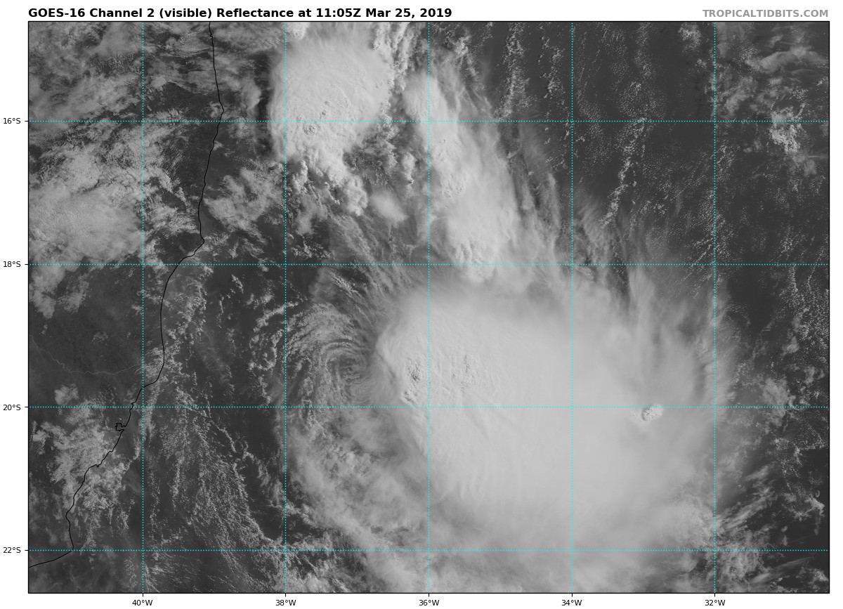
Before jumping into the forecast, I just wanted to note an oddity developing off the southeastern Brazilian coast—Tropical Storm Iba. This is the first tropical cyclone to develop in the southern Atlantic Ocean since Tropical Storm Anita, in 2010. Such storms are rare in the Atlantic, south of the equator, due to typically very high wind shear conditions. In this case, Iba should last about 24 hours and does not appear to be a significant threat to land. (I also wouldn’t read anything into Iba’s development with respect to the upcoming North Atlantic hurricane season, which begins June 1).
Monday
It’s warm, humid and (for some parts of Houston) foggy this morning as the region lies under a southwesterly flow. Temperatures are in the upper 60s. But a front is coming, and along with it more spring-like weather. Conditions will remain mostly cloudy through the early afternoon, with temperatures rising to about 80 degrees for the area. A diffuse area of showers and thunderstorms will move into Houston this afternoon—most people probably won’t see rain—that will herald the arrival of the front. It should move offshore this evening, allowing for clearing skies and a pleasant night in the upper 50s.

Tuesday and Wednesday
Expect a pair of amazing days, with highs in the mid-70s, sunshine, and cool nights in the 50s. Can you beat this? You cannot.
Thursday
We’ll start to see some clouds return Thursday, as the onshore flow kicks in. But this should still be a nice day with temperatures in the 70s and a bit warmer night in the 60s.
Friday, Saturday, and Sunday
And then, the weekend. We still have more questions than answers, but Friday definitely looks to be a mostly cloudy day, with perhaps a 30 percent chance of showers, and highs near 80 depending on whether much afternoon sunshine pokes through. After a warm-ish night, Saturday will bring more clouds, humidity, and highs near 80. Based upon the latest guidance, and much can change between now and then, the best chance for rain will come between noon Saturday and noon Sunday, with perhaps a few tenths to one inch of rain for much of the area. Cooler temperatures will arrive on Sunday, with highs perhaps in the 60s.
After the front passes, later Sunday and the early part of next week look fairly sunny and pleasant again. Spring isn’t going to last forever, so get outside and enjoy it this week and (if we’re lucky) next week.
Standing by for Iba here in Katy.
I am crossing my fingers and praying that by the end of the week your forecast for Saturday changes and there is no rain!
Be interested to know early thoughts for the next weekend as to the best day to attend the CAF event. https://www.eventbrite.com/e/2019-warbird-weekend-tickets-57429066885?aff=Website
Hi Mark. It’s just too early to say much about weather 12-14 days from now, especially with any kind of precision for a Saturday vs Sunday.
What I like about this time of year is the wildflowers, and the period when temperatures don’t go below 45 or 50 and don’t go above 80 or 85. this allows me to not use heat or AC (or perhaps very sparingly) and thus have low utility bills. Sometimes this period lasts for a several weeks, and other times only several days.
Jason, I call days when neither the heat nor the air conditioning is required “golden days”. Here’s hoping for a bunch of them upcoming!
Spring is far, far too fleeting. But it’s sure nice while it lasts.
Will the hair salons be advertising Iba Brazilian Blowouts?
No rain to wash away the pollen?
And the ash and benzene?
Please no rain this weekend it’s my daughter’s wedding
Do you expect thunderstorms with the weekend rain chances? Have a Cub Scout camping trip this weekend and starting to get worried about it getting canceled.
Do you expect thunderstorms & lightning with this weekend’s rain chances? Have a Cub Scout camping trip this weekend and getting worried about it being canceled
Tuesday/Wednesday
“Can you beat this? You cannot!”
– So very true