Since our post last week, Tropical Storms Bonnie and Colin have formed and exited the Atlantic basin. Looking ahead, those should be the last storms for a bit.
Tropical outlook in a sentence
Over the next week (or longer), we are not expecting any new systems of note in the tropical Atlantic.
Bonnie & Colin
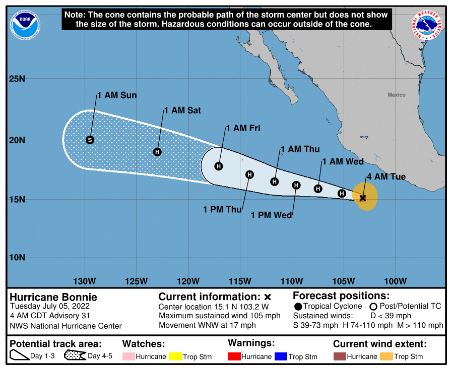
This time last week, we noted that PTC #2 would likely become Bonnie and “has a chance to become a hurricane as it approaches Central America, but it probably has equal chances of not being one too.” As it turns out, the latter was correct. Bonnie’s forward speed and a bit of shear was just too much to overcome, and the cyclone never organized until it moved into the Pacific. Since it held itself together across Central America, it retained the name Bonnie, and is heading out to sea.
Meanwhile, Colin formed briefly off the Carolina coast, somewhat of a surprise from last Tuesday’s post. Colin didn’t last long, about 24 hours from Saturday through Sunday, and it dumped a few inches of rain in parts of the Carolinas.
2022 to date
With Colin’s development, that puts us at 3 tropical storms as of July 5th. They’ve combined for an “accumulated cyclone energy” of about 2.8, which is right on normal for this point of the season.
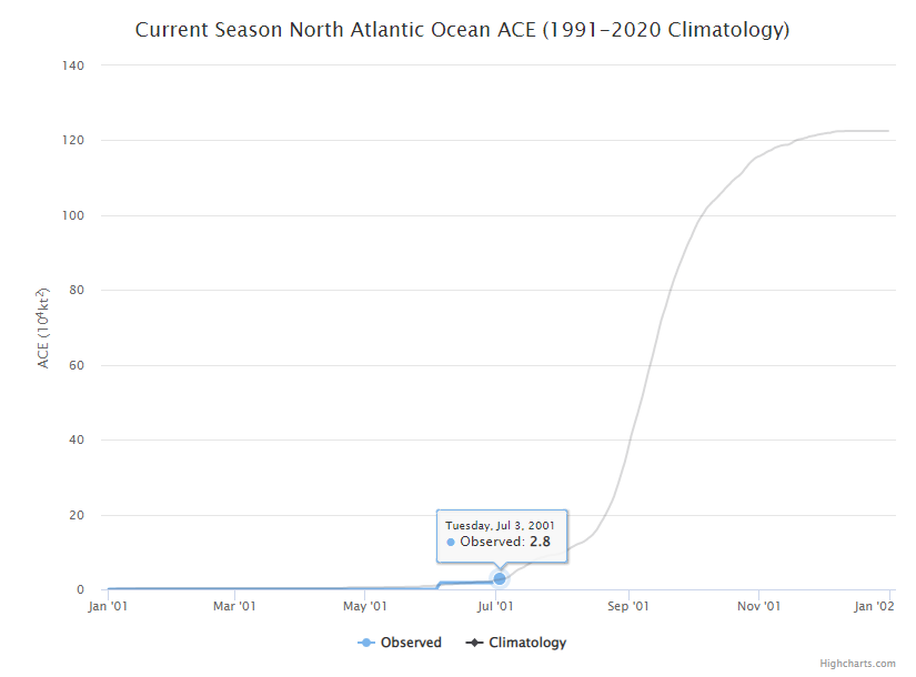
ACE tallies up how long a storm maintains a certain intensity during its lifetime. The bigger the storm, the bigger the ACE, and obviously the more of those storms in a season, the higher the value will be. Typically, our 3rd storm does not form until early August, so from that point of view, we’re cranking. But they’ve all been fairly weak systems, so overall our season is off to a mostly normal start, which is nice for a change.
That said, note from the chart above that we still have roughly 97.7 percent of the season ahead of us from an ACE standpoint. Again, it’s normal for the early season to be generally weak.
Looking ahead
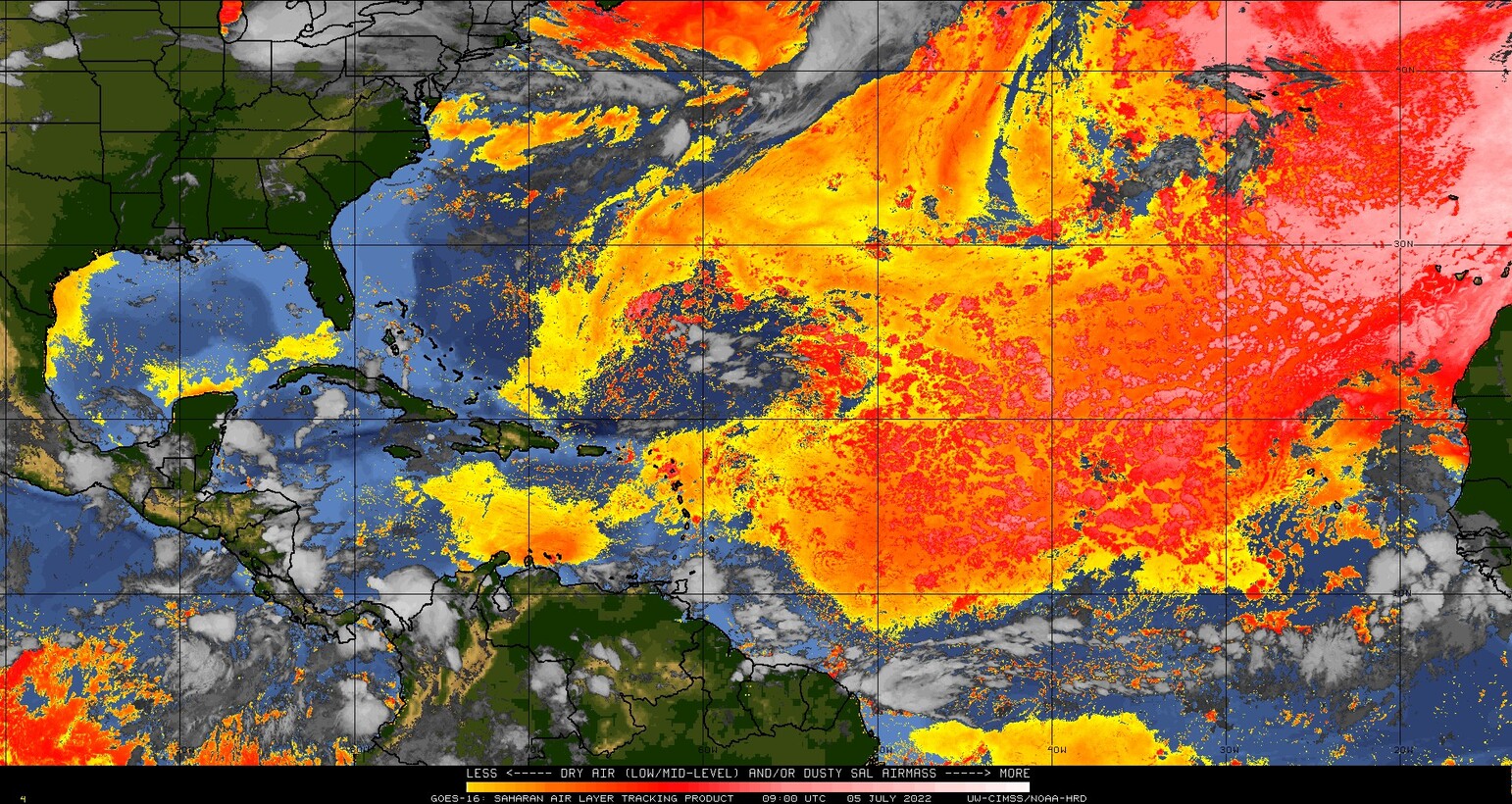
Over the next 7 to 10 days, we are not expecting any tropical development in the Atlantic. As always, you could get a Colin scenario, where something brief and weak can spin up close to home. Short of that, however, it appears dust and minimal tropical waves of note will be the story over the next week and probably a bit longer. Dust tends to indicate dry air is present, which is not something tropical storms care for. This is also the time of year we expect widespread dust over the Atlantic basin.
Some of the typical things we’d look for to kickstart tropical activity are sitting out there on the horizon per the models, so I would expect maybe the last week to 10 days of July to provide some items to watch, but that’s purely speculative right now. For now, enjoy the quiet we have and use it as an opportunity to ensure you’re set for the August and September gauntlet.

So, leave town this month to get out of the oppressive above average heat (assuming you can actually get on a flight and can afford the ticket) but be back by early August (assuming you can actually get back from wherever you went) to protect your property and prepare your evacuation from possibly multiple hurricanes. Like the Cat 6 storm that has your name on it.
Got to love 2022…….
I heard that Sarasota Florida does not get hurricanes. Is that true?
All of Florida gets hurricanes.
No place in Florida is immune from hurricanes. That said, some places are bigger targets than others. Sarasota has had 30 hurricanes that we know of track within 60 miles of the city, including 2 near-direct hits in 1944 (Cat 2) and again in 1946 (Cat 1). Miami has had 43 hurricanes with those same parameters (60 miles of the city). Now, if you want to talk the big dogs (Cat 3+), here’s how various Florida cities do. Again, this is the number of storms recorded within 60 miles of the city:
Miami: 20
Fort Myers: 18
West Palm Beach: 16
Sarasota: 11
Destin: 11
Tampa: 10
Orlando: 8
Jacksonville: 6
Tallahassee: 4
You can tinker more here: https://coast.noaa.gov/hurricanes/#map=4/32/-80