It’s kind of crazy to think that our last full tropical update was two weeks ago, and we noted how things were about to ramp up. For many folks in Louisiana, the world is a much different place today than it was then. For Houston, I think we had a moment there. You exhale, but then you realize that nothing has really changed, and all it takes is one more storm to bring us right back to where we were sitting in the days before Laura. So will that happen? Probably not, but let’s walk through things.
Tropical outlook in a sentence
We expect several systems to develop over the next week or two across the basin, but right now only one of them is worth seriously watching and even it will be racing against the potential cold front next week.
Potential Tropical Cyclone 16
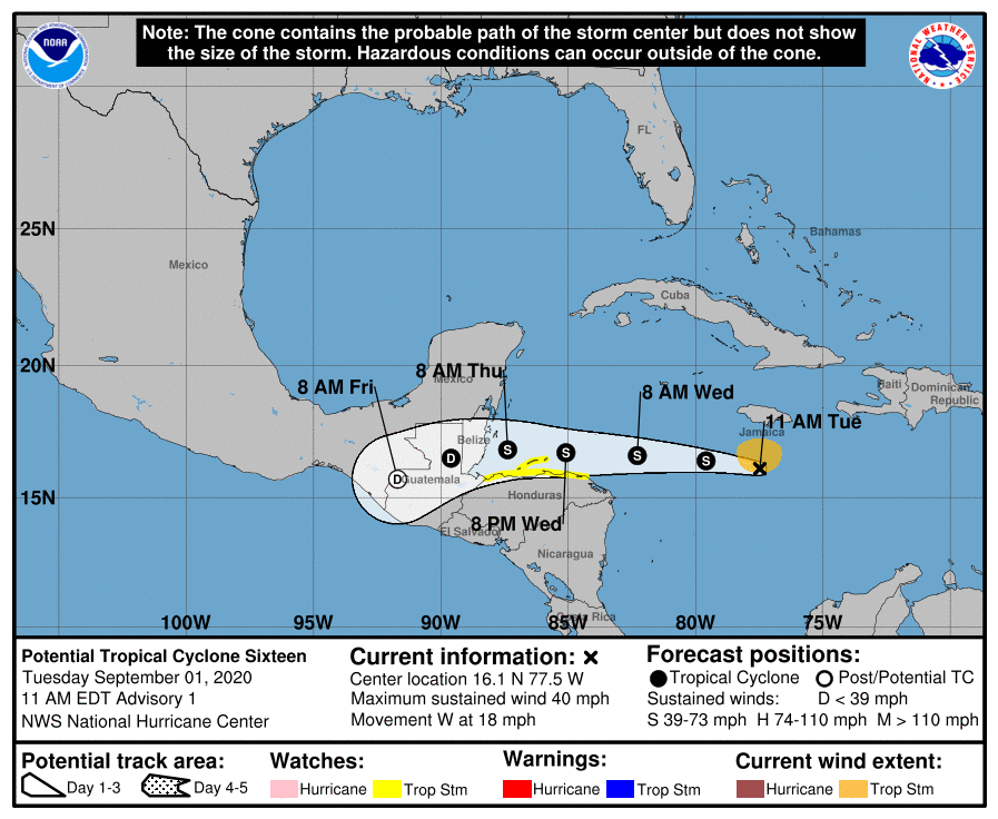
The system that we referred to as Invest 99L yesterday has been classified as Potential Tropical Cyclone 16 (PTC 16) in the Caribbean this morning, meaning it is expected to become a depression or named entity soon. It looks fairly healthy on satellite, and it will likely develop over the next couple days.

Fortunately, thanks to our oppressive heat in Texas, with sprawling high pressure over the Gulf of Mexico, this will keep PTC 16 well to our south. No need to worry about this coming to the Gulf. So what is coming after this system?
Behind PTC 16
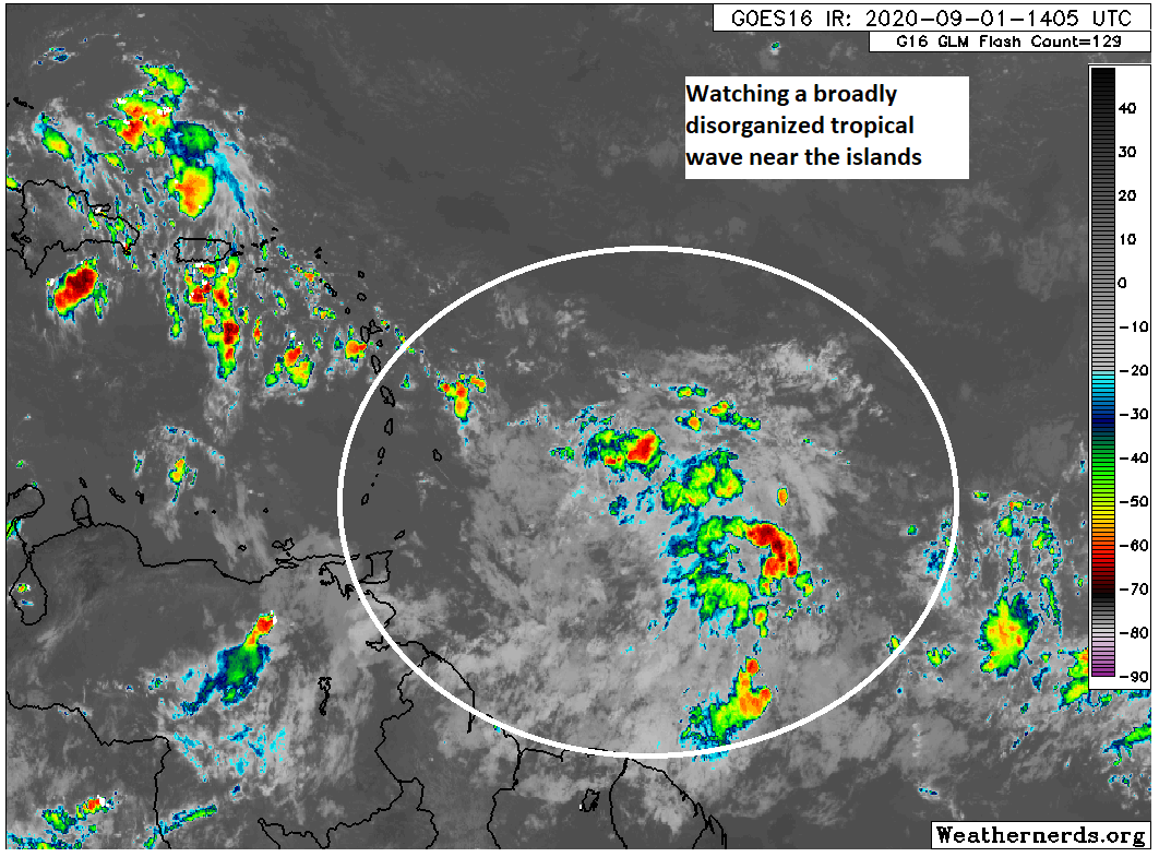
It seems like all these systems have another one trailing them that’s of more interest to us than the first one. This case is no different. There are a number of different models and ensemble members at least hinting that the wave behind PTC 16 is going to broadly track toward the Gulf early next week and may slowly develop. The National Hurricane Center has even removed this wave from its areas to watch today. So the ceiling on this one seems fairly low, and current levels of support for this system are far lower than what we saw at this point in the run-up to Marco and Laura.

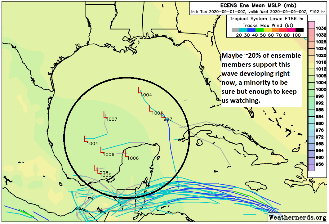
This wave is expected to come westward over the next few days and probably not develop. Eventually, as the ridge over the Gulf breaks down and the U.S. weather pattern makes a big time change that should allow a cold front into Texas, that system will get drawn back north toward the Gulf. Our gut feeling this far out is that the system is going to struggle even as it gets lifted northward. But there will be a small window for some possible development as it moves into the Gulf early next week. For the Euro ensemble in particular, only about 20 percent of the 51 different ensemble members develop this into anything worse than an invest-level system or depression by next Tuesday evening.

With the front penciled in for next Wednesday, that should be enough to either keep it squashed in the Bay of Campeche as a weak system or capture it and send it along the front north and northeast away from Texas. We’ll still keep tabs on it just in case the front fails or something, but at this time we are not really worried about this one becoming a big problem for us.
More to come
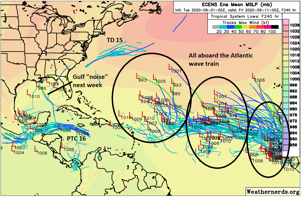
There is a good chance we will see at least two or three more names get used over the next couple weeks. In addition to PTC 16, we have Tropical Depression 15 off the coast of the Carolinas that is racing out to sea. There is only a slight chance it will garner a name. After the Gulf “noise” next week, we have three separate areas showing up in the Atlantic on the Euro ensemble, as well as on other models.

I would assume at least two of those clusters would develop into a named storm. So there is a good chance we will run through at least two or even three more names (Nana, Omar, and Paulette), possibly more over the next couple weeks. It is too early to say if any of these will ultimately pose a Gulf threat. Certainly, the prospects of a cold front next week has folks excited, but it’s important to remember that one cold front in early September doesn’t magically end hurricane season for us. Things can change, so let’s keep our head in the game for a few more weeks.

Why are invest numbers only 90-99? Seems like it would make more sense to just start at #1 instead of re-using the 90s over and over each year.
My guess is they’re using the same numbering system as the full-blown cyclones (for example, Laura was #13) so they’re trying to avoid clashing with those numbers.
Just how it is. As someone replied, it may be to avoid confusion with cyclone numbers. But it’s just mainly meant as a placeholder. Invests really were never meant to be in the public lexicon, but here we are.
Sometime explain how, why and at what location in South Africa this all starts. Also does this activity affect and populated regions in So. Africa?
West, not South Africa. They start in the general flow of air east to west over the Sahara/sub-Sahara. They don’t have much affect until they move out over the Atlantic, pick up heat from the ocean water, and develop (or don’t develop) into tropical depressions, etc.
The ‘Stuff You Should Know’ podcast just did a very good episode last month explaining exactly this dynamic – how it starts, how it either develops or doesn’t, etc. Worth taking a listen to answer your question.
I don’t like this. AT ALL!
Me neither – #ihatehurricanes
Might also add about fronts that they themselves can sometimes sag in the Gulf and turn into systems.
Correct. In this case, the thinking is that if we do get the front, it will be pretty progressive, so that specific scenario seems unlikely here.
Currently, I am due to fly into Cozumel (from Houston) on Saturday, September 12. Do you foresee any issues either with the flight from Houston, or a 6 day stay in Cozumel from 09-12 – 9/17?
It’s much too far out to speculate on that time period. We just simply don’t know what that line up of systems in the Atlantic will do. There’s a good chance you’ll be just fine, but there’s a chance you won’t be either. Your best bet is to stay tuned. Wish the answer could be more clear cut than that.
I know I have to keep my head in the game, but all I hear is FRONT
any chance you will have any commentary on current Pacific activity (typhoon maysak)?
Looks like that system in the Caribbean may play hell with the Bay Islands north of Honduras.
Hi Matt, if Galveston takes a direct hit from say a cat 4 storm that then heads east, how far north and how far west do you think we’ll see wind damage? In your opinion is there any part of Houston that would see minimal damage after a direct hit to us? Thanks
Generally, the farther N & W from Houston the less likely you would be to experience wind damage from a storm like Laura. Even Laura brought 100 mph wind gusts inland almost as far as Alexandria, LA, which is 110 miles from Cameron, where Laura came ashore. So in a worst case scenario, you’d still be talking damaging wind as far north as Conroe or Navasota. That’s assuming a landfall farther south (closer to Freeport and a due N track). Tough to escape the risk entirely, but in general, the farther N & W you go the better.
Well, we seem to have run through two more names just today. Any bets on how far down the list we’ll be in two weeks?
In 1995, Hurricane Opal happened in early October and, after walloping Tallahassee, paid us a visit as far north as Atlanta. It was an expensive hurricane. Tanya was the last one in late October. Luis became a hurricane at the end of September. This year, Laura landed at the end of August. I believe we will run out of the alphabet, if things continue like this.
So now I am officially ticked off at the people who pick names for hurricanes. We do not need to use a much loved named for grandmothers as a blipping hurricane name. Thanks a lot folks. I’m a proud Nana, but good grief it’s a nickname for the most part. Leave us grannies alone will ya? Hmph. Lol. Well, it is said, at least in the South, that one of the most powerful forces of nature on Earth is a grandma. Lol. My family is definitely getting a chuckle out that name on the list. I just hope the name doesn’t get used. We’ve seen enough for 2020.
Thanks Matt!