Not every part of Houston received rain on Wednesday evening—some parts of Katy, Kingwood, and Galveston saw a lot of lightning, but precious little precipitation. But for much of the metro area, the rain did come come, in sheets, falling onto dry ground and streets so hot after seven days of 100-degree heat that they steamed afterward. For me, it brought to mind a classic Steve Earle song, The Rain Came Down, about a farmer desperate for rain, with lyrics such as, And the rain came down, Like an angel come down from above. It did feel pretty amazing.
Thursday
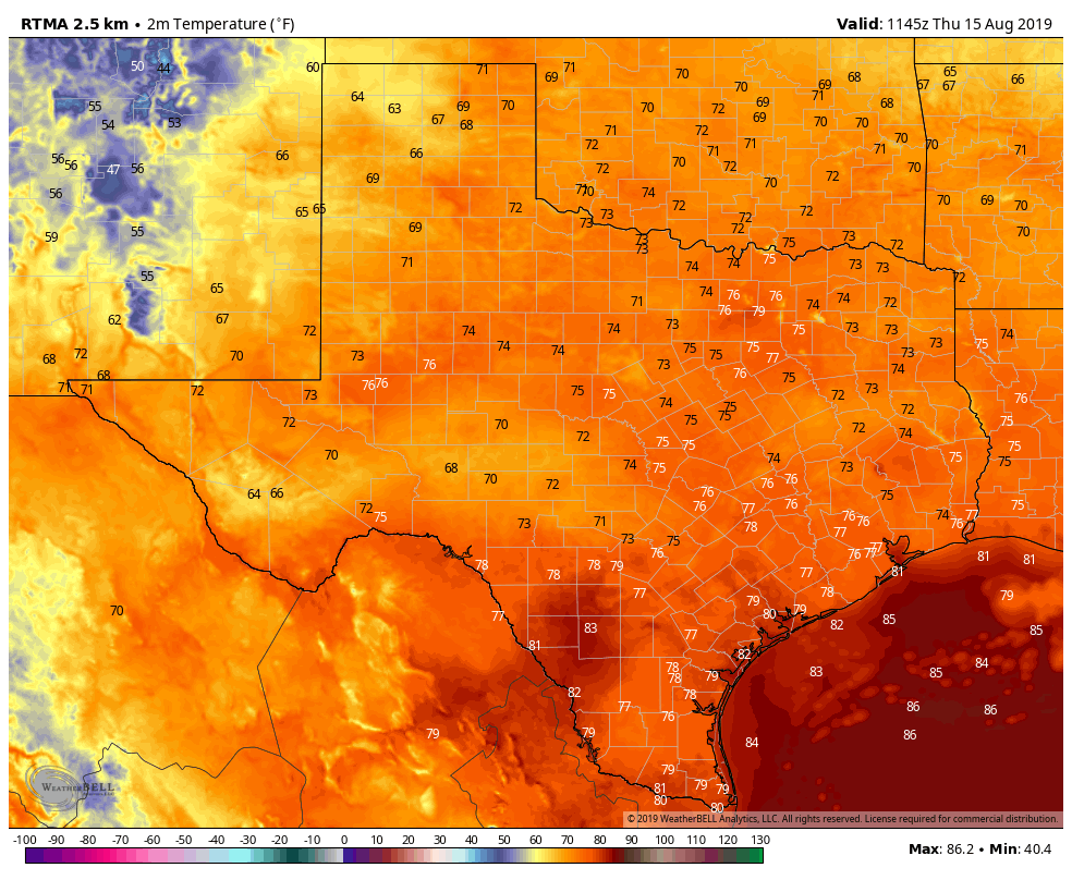
For all but the immediate coast, temperatures have fallen this morning into the mid- to upper-70s, which is cooler than most of the last week. With partly sunny skies, we’re still going to see a warm day today, with highs likely reaching into the upper 90s. (It is mid-August, after all). The focus for showers and thunderstorms today will likely occur closer to the coast. High-resolution models indicate the potential for active weather to the southwest of Houston, in Fort Bend and Wharton counties, as well as to the east in the Beaumont area. But with that said, I think rain chances in the Houston metro area itself are probably about 40 percent this afternoon and evening.
Friday
This should be a bit drier of a day, with perhaps only 30 percent rain chances and mostly sunny skies. It will remain quite hot, with highs in the upper 90s, and a few inland areas possibly seeing 100 degrees.
Saturday and Sunday
The weekend forecast remains difficult to nail down because the Houston region looks to be in the middle of high pressure to the west, and low pressure over the upper Midwest. As a result our weather could really go two ways—trending hotter and drier, or opening up to Gulf moisture and seeing passing rounds of storms. For now, rain chances are probably about 30 percent on both days. Hopefully Matt can make some sense of this in Friday’s forecast outlook.
Next week
The first half of next week looks pretty hot with continued scattered showers. After that, there are some indications that we’ll move into a more moderate pattern temperature wise. But as high pressure backs off, we may become more susceptible to rainfall from the Gulf of Mexico. However, it’s too early to have much confidence in this scenario, or any details.
The tropics
The Atlantic tropics remain quiet, a welcome sight in mid-August. However, as we’ve been saying, the second half of the month may become more active, as there is some indication in the ensemble forecast models that the western Caribbean Sea or Southern Gulf of Mexico may see some development 7 to 10 days from now.
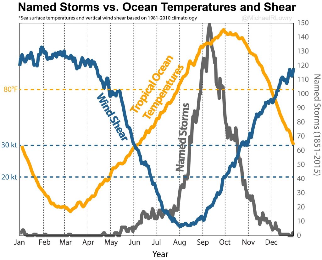
This is not something to be particularly concerned about right now, for sure, but we are at that time of year when ocean temperatures are near their peak, and wind shear near its lowest. So we’re paying attention.
The wx reports that we get are still saying there’s little chance of development in the Atlantic — “Dry and dusty air”.
Bellaire had a nice hard shower yesterday, I am thankful.
Keep up the good work, SCW.
Atascocita: Zero point zero inches of rain yesterday. The sprinklers will continue to run.
Same here by me in Katy 🙁
Welcome rain and wind in Spring Branch last night. Any break from this uncomfortable heat I’ll take.
It was amazing wasn’t it? Maybe my yard won’t die.
My (highly unofficial) red neck rain gauge indicated about 0.15 inch in the northern Spring Valley area. Not much but enough to get thru roday without running the sprinkler.
0.3″ around Ellington, but better was watching the temperature drop 16 degrees in less than an hour.
Thanks Eric for our faithful updates!
Nice rain shower in La Porte yesterday.
I got in truck around midnight last night, turned on the vent and thought I had the AC running for a moment. Much better than the recent 84 degree midnight temps. I love rain, and I love Steve Earle.
East side of Pearland got a good soaking!! Appreciated the drop in temps for certain. Thanks for your hard work keeping us informed.
Good graphic. Thanks for providing it.
My corner of Katy finally got some rain. I am happy that 0.44 inches fell but I could have used a lot more. The temperature drop was delightful, though!
Why is wind shear lowest in Aug/Sep when water temp the highest? Are these related?
If I’ve correctly understood the explanations given here in the past, they aren’t directly related to one another, but are both a result of the same cause, namely the Northern Hemisphere tilting towards the sun during the spring and summer.
Wind shear lowers because the jet stream moves north. The jet stream movement, in turn, is because air in the Arctic region warms in the summer.
Ocean temperature rise is easy to understand: longer days and more direct sunlight.
Both of these lag behind the sun being furthest north because natural systems have a lot of thermal mass.
With the warming of the Arctic and increasing melting of arctic ice, is it expected that the periods of lower wind shear will start to extend?
thank you, i was about to ask a similar question
i don’t suppose there have been or are instances in which this doesn’t occur and if so, what caused those conditions to be lacking……..
.12″ at my house in the Champions area yesterday. I ran the sprinklers last night figuring the rain gave them a head start. Grass looks a little greener this morning.
Finally someone closed the umbrella over Jersey Village!! We got 1 1/2″ of rain!! However, I feel it came all at once and the ground was so hard and dry that the majority probably ran off into the street. 🙁 BUT, I’ll take it! Gimme more!
From June 30 – Aug 13: 0.56 in rain total (avg 0.012 in / day)
Aug 14: 0.92 in rain
according to closest Harris County Flood Warning system gauge (< 1 mile)
Thanks for rubbing it in Eric! That’s like saying…
“Not everybody got ice cream today, but for those of us who did…it was so creamy, smooth, delicious, and refreshing! It was by far the best ice cream I’ve ever had! Only for those of us who got some of course!” 🙂
I’m just messing around. Thanks for the updates and the work you guys put into this brother.
You forgot to say that it was “Blue Bell” …