Thursday broke the streak. We fell one degree short of 100° officially, after 7 straight days of 101°+ in Houston. We don’t think we will hit 100° again for a bit, though I suppose one could sneak in here at some point over the next few days under the right setup. Regardless of all that, it continues to look hot and unpleasant for the foreseeable future, but at least we can mention a chance of rain almost every day.
Today
Radar this morning is already showing some showers and storms, mainly along the coast or east of I-45.
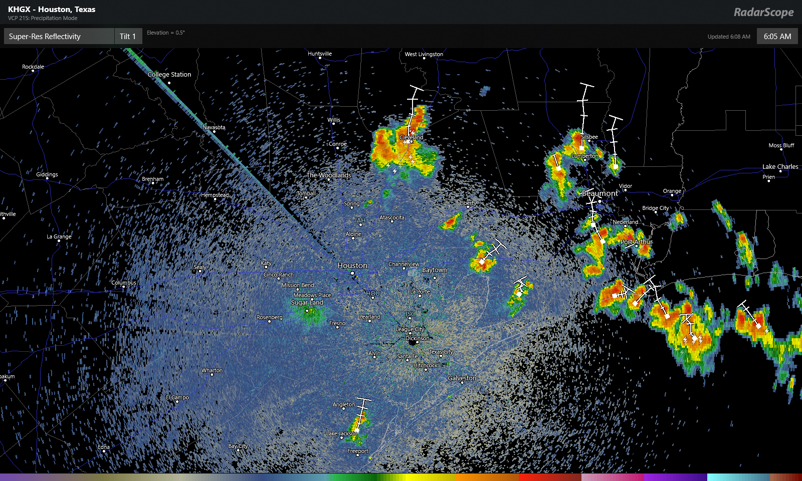
The storms were slowly drifting to the north. These should gradually fade this morning, and we’ll expect sun and clouds with high temperatures aiming for the upper-90s once more. Air quality today will be fairly poor, so if you fall into “sensitive groups” on days with high ozone levels, you will want to take it easy and stay indoors when you can. A few additional showers are possible this afternoon with daytime heating, but like yesterday, consider yourself lucky if you see one.
Weekend
Both Saturday and Sunday look pretty standard for what we normally expect in the back half of August. Look for a mix of sun and clouds on both days. Saturday will see isolated to scattered showers or storms in the afternoon. Sunday will probably see slightly fewer showers. Rain chances will be highest as you go to the east of Houston. So Baytown likely has higher odds of seeing a shower than Katy this weekend.
High temperatures will likely top off in the mid- to upper-90s, while morning lows will remain steamy at around 80 degrees.

Monday through Wednesday
As high pressure in the upper atmosphere flexes again over Texas early next week, look for hot weather and minor rain chances each day. We will see if any disturbances can boost rain chances on one of the days. All three days should top off in the mid- or upper-90s, with lows near 80° or just a little lower.
Tropics & late next week
As we’ve been telling you, the tropics won’t stay quiet forever, and it appears we will have something to watch in our backyard as early as late next week.
For several days now, modeling has been at least hinting at a possible disturbance near the Yucatan next week that tries to drift into the Gulf. Most modeling seems to be on board with this scenario. They differ markedly on the details, as is usually the case this far out, with the GFS ensemble modeling aggressively trying to organize a tropical system, while the European model and ensembles remain mostly disorganized or weak. They also differ on track, with the GFS favoring the Texas or western Louisiana coasts, while the Euro is a bit broader, keeping options open between Florida and Mexico.
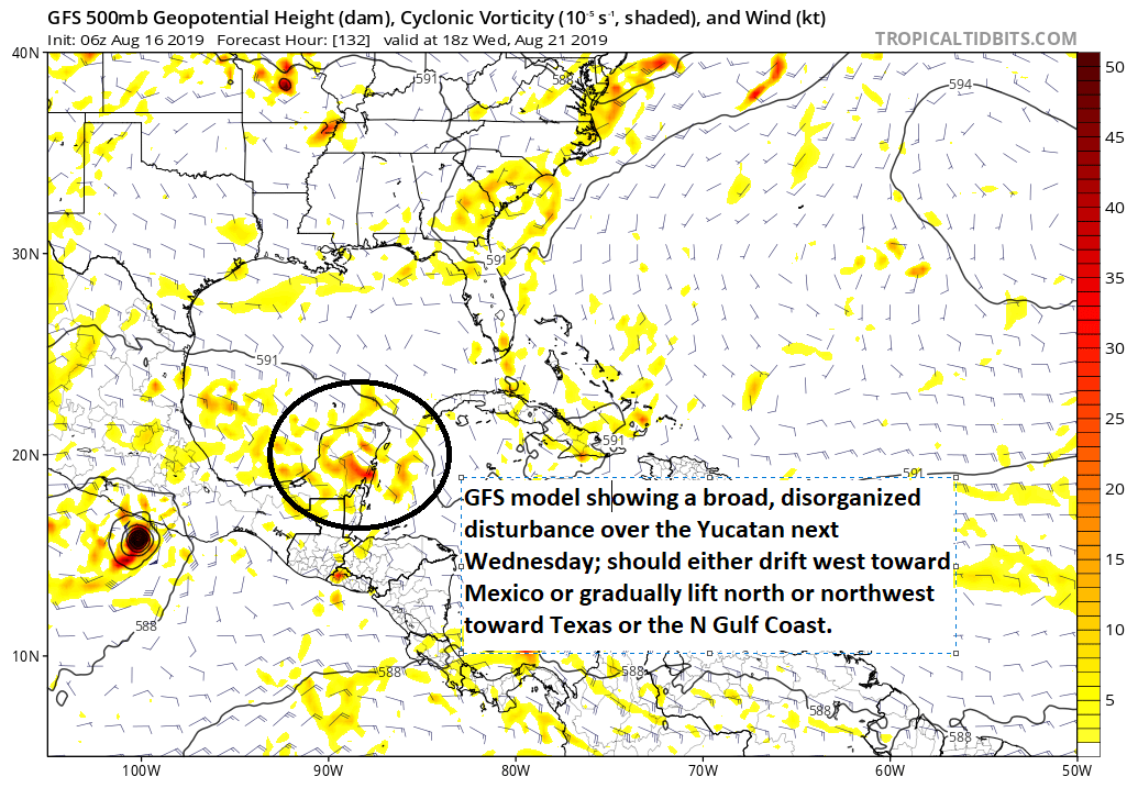
It is far too early to speculate on the details around what may happen late next week. But regardless or whether or not an organized system develops, there will likely be an increase in rain chances between the Coastal Bend and Louisiana late next week or weekend. In the Atlantic, things remain quiet for another week to 10 days or so before we should begin to see some nascent activity. Eric and I will keep you posted and have a full update on this Sunday or certainly Monday.
Bring that tropical rain!
Obviously, you didn’t flood during Harvey. Be careful what you wish for.
“the back end of August” – beautiful words.
Finally got a few drops of the wet stuff in my corner of Katy last night, but not enough for me to turn off the sprinklers set for this morning.
“…modeling has been at least hinting at a possible disturbance”…what makes up the “hints”…what factors seen at this point potentially suggest something may form over the Yucatan days from now? Matt, thanks again to you and Eric for the service this site provides! Have a pleasant day…
Well, you see a definitive disturbance show up on modeling. Sometimes the model run takes it into Mexico. Sometimes more into the Gulf or toward Texas, but over the last 3-4 days, it has shown up more frequently in modeling, which to me suggests it’s real. If you look at all the ensemble members, where they run the model 20 to 50 times with slightly different initial conditions, you see a percentage of ensemble members spinning up a low pressure in the Gulf next week. Only the GFS model is being very aggressive with it, but other models show signs of it as well. So, there’s hard evidence supporting a disturbance. “Hinting” may be slightly misleading, but I think you get the idea here. Thanks for the kind words!
Matt…appreciate your time responding…I suspect there’s a bunch of environmental data that gets mixed together resulting in a forecast…forecasting seems to keep improving…it’s clear that you all work hard to find and follow truth as best as you can…I don’t ever want to see either of you standing in a street with water up to your waste or leaning 45-degrees into the wind to keep from being blown over telling me it’s raining hard and by the way it’s windy also!
It’s hotter in Florida..Hope that makes someone feel better
Matt and Eric thank you for everything you put into this. So what you know so far is there concern?
Thanks! No concern. Just something to monitor.
Thank you very much. It is appreciated.
I love this blog, thank you so much guys. Y’all are talking about the tropics before it even hits the NHC which is much appreciated.