The Houston region missed out on most of the rainfall associated with a tropical disturbance Monday, as the Beaumont area got the worst of it with 5 to 7 inches of rain falling in some areas, and in some cases more. The atmosphere remains pregnant with moisture, however, and while Houston lies between heavy rainfall to the east (near Beaumont again) and to the southwest (near Corpus Christi) this morning, it is likely that one of these long rainfall bands moves over the Houston region eventually today. For this reason, the National Weather Service has placed Harris, Chambers, Galveston, Brazoria, and Fort Bend counties under a flash flood watch through 7pm today.
Tuesday
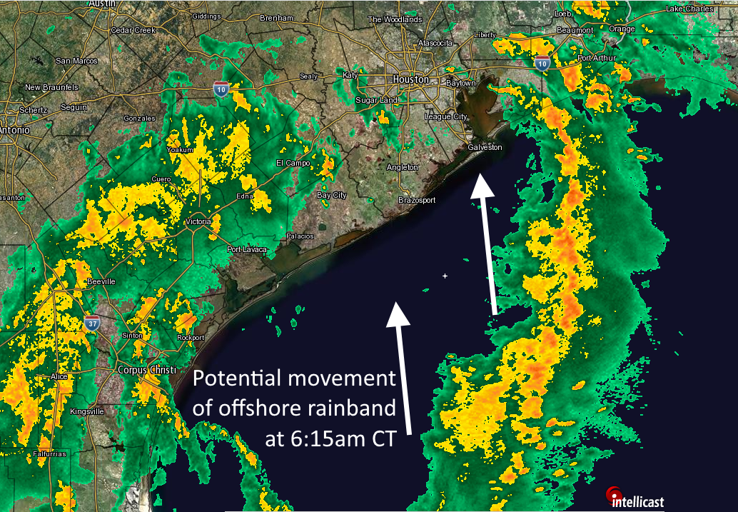
The much-discussed tropical disturbance has moved inland, into Texas near the Coastal Bend, but it will continue to serve as a focus of low pressure and atmospheric moisture for a few days. Given the long, banding feature on radar over the Gulf of Mexico on Tuesday morning, it is clear that somewhere along the upper Texas coast is going to get a healthy amount of rain today, probably on the order of 4 to 6 inches as training showers move inland. Whether that’s central Houston, Baytown, or somewhere between Baytown and Beaumont is less clear. For this reason it is probably safest to expect widespread totals of 1 to 3 inches of rainfall if you live in the counties in the flood watch area, but realize there is a chance for considerably more than that. This probably is still just a street flooding issue, although I’m a bit concerned about Baytown and points immediately east of there that received 3 to 4 inches of rain on Monday.
Regardless, today is a day to be aware of weather, anticipate the potential for street flooding, and check conditions before making a drive across town. We will update this site as warranted.

Wednesday
Conditions remain favorable for heavy rainfall on Wednesday, although we probably won’t see the banding features on radar that exist this morning, and therefore the overall threat of heavy rainfall is probably diminished. Nevertheless, for areas that get sodden today, flooding could be a concern on Wednesday if the storms strike the right areas. We probably won’t have much intelligent to say about the potential for flooding in Houston on Wednesday until we get through Tuesday.
Thursday
Showers are likely again, but the disturbance driving these storms will be losing its oomph, and we expect less organization and less overall coverage. Impacts, again, will be determined by what happens on Tuesday and Wednesday.
Friday, Saturday, and Sunday
The weekend still looks reasonably nice for Houston, given the time of year. Although we can’t rule out some scattered showers during the afternoon and evening hours, for the most part I’d anticipate partly to mostly sunny skies with high temperatures in the low 90s.
Trying to drive to Mobile AL today. Looks like if I can get out of Houston (not driving truck or SUV) I should be okay. Trying to decide if best to get away ASAP or if I should wait till later to leave.
Either should be OK, but before noon is probably a good time to leave. You’ll have a chance of heavy rain until the Texas-Louisiana border.
THX. Drive was difficult but I made it. Actually worse than driving into Harvey last August because rain was unremitting until after Baton Rouge. Beaumont was the worst. Always thx for your careful forecasts and analyses.
My wife has plans to drive to Hallettsville using 59 and then Alt 90. What would be the best time for her to travel? Thanks.
IF this band moves into the area, is this a morning event? Afternoon? Evening? Or is it still just up in the air. I have some across town errands to run in a flood prone area and Im trying to time when is the best time to go.
Up in the air, unfortunately.
ha! literally
We must be in one of those minimal-rain zones – only .4” so far. North of Richmond, south of Katy. A little more would be nice.
Goo Morning,
How is tomorrow afternoo is looking to You; catching 4 pm flight…
Thanks,
Alex
Goo Morning,
How is tomorrow afternoon is looking to You; catching 4 pm flight…
Thanks,
Alex
NWS Doppler showing continued heavy rains in the Beaumont area. Praying for those folks. Little break to allow for some runoff would be nice for them.
I’m in Old Katy area, and we’re getting nice downpours as the smaller bands pass though, then a break. So far, it’s been a perfect rain the past two days for our area.
The Beaumont area is getting hammered, around 10″ cumulative at the Beaumont airport since 6AM Sunday. If that area of training rain had been over Harris county we would have had big trouble.
But here in Champions we had .8″ on Sunday, .24″ yesterday, and .20″ so far today.
Brother who lives in Port Arthur says they’ve received over 7 inches already. There’s some street flooding there.
So far (heights) is doing pretty well. Couple of big spout downpours, then lulls in rain. Not overly concerned, just keeping an eye on it
Houston has horrible weather.
Wow, the ultimate behavior of this system shows how difficult it is to forecast them, even with the best technology available. As usual, excellent job with no-hype information.