Unsettled weather will continue for Houston today, as relatively small-scale, but intense showers and thunderstorms bring widespread rainfall to the area. These are nasty storms to try and forecast because while parts of central and southern Houston have received less than one-quarter an inch of rain during the last 24 hours, some parts of southern Brazoria County have received more than 9 inches.
Today
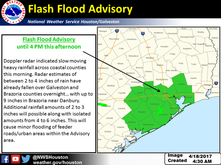
A flash flood watch remains in effect for central and southern parts of the Houston metro area today through about 4pm, as the heaviest rains are likely to continue to fall between the coast and downtown Houston. The storms are being driven by high moisture content and small features in the atmosphere. Additional rainfall amounts may be as much as 2-3 inches of rain, with higher isolated amounts.
These storms have been pretty unpredictable (certainly there was little expectation of a nine-inch rain bomb just south of Houston on Monday and Monday night), so we’ll have to keep on alert for most of today. While I don’t expect major problems for most of Harris County, you just never know when atmospheric moisture levels get this high (about 1.8 inches of precipitable water) during the spring and summer months in Houston.
(Space City Weather is sponsored this month by The Mole, a Jonathon Price novel.)
Wednesday
The threat of heavy rainfall should come to an end on Tuesday night or Wednesday morning, but some showers and a few thunderstorms could linger into Wednesday. Highs will be around 80 degrees.
Thursday and Friday
As high pressure builds into the area, look for calm, warm weather. While we can’t entirely rule out a few scattered, afternoon showers and thunderstorms, most of the region should remain dry under mostly sunny skies.
Saturday
We’re still expecting a cold front to arrive on Saturday, but its passage may not come until the afternoon or evening hours. Right now the global models are pretty consistent with keeping severe weather to the north of the Houston metro area, so my expectation for Saturday is the possibility of light rain (as in hundredths of an inch) for most of the area rather than any significant accumulations. I’d look for highs in the low 80s before the front moves through later in the day.
Sunday and Monday
After the front moves through the start of next week should be completely spring-like, with highs in the low- to mid-70s, overnight lows in the 50s and generally beautiful weather. Certainly, something to look forward to.
Posted at 6:40am CT on Tuesday by Eric
Interesting wake-up this morning when the TV kicked on at 0530 and I spend the next 15 minutes trying to figure out what the heck just happened to the south of me and where it was headed.
Leaving for work I could see the lightning to the south…. kind of like watching a battle from the rear areas.
About 0.7″ in the rain gauge from overnight in beautiful downtown Ellington.
We’re getting hit pretty hard in Galveston County. 🙁
About 2″ for the last 24 hours.