Good evening all. We wanted to give you an evening update on the incoming rain event for Wednesday. Truthfully, not much has changed from Eric’s synopsis and outlook this morning. But we want to freshen up some thoughts around timing, amounts, severe weather, and so forth.
Quick Summary
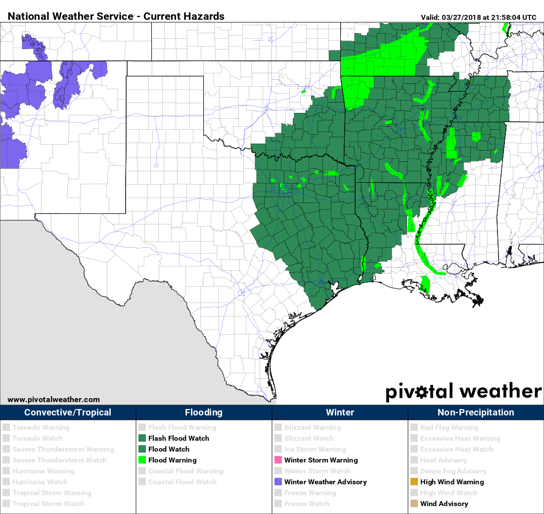
- Flash Flood Watch begins at 1 AM Wednesday north & west of Houston and 7 AM in Houston and points south & east.
- Heavier rains stay north & west of Houston later tonight and Wednesday morning. Isolated strong to severe storms are possible tomorrow afternoon, especially along and southeast of US-59/I-69. Widespread heavy rain and storms moves through with the front later Wednesday evening.
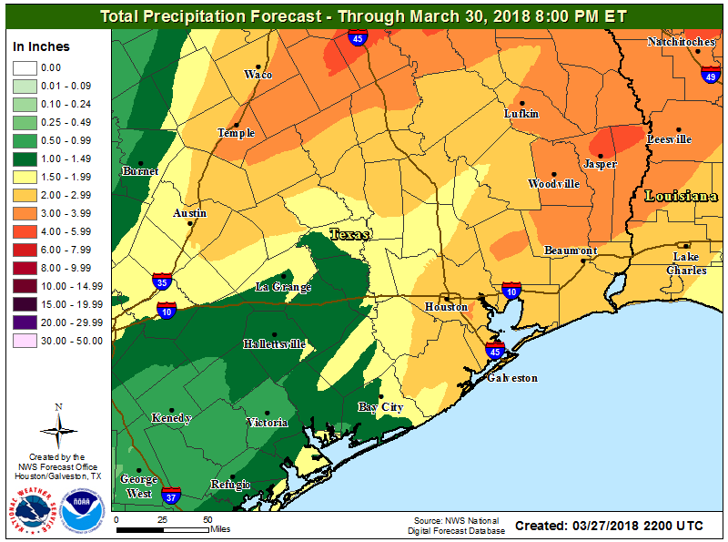
- We still believe 1-3″ of rain on average will fall with a few pockets of 3-5″ or a little more not out of the question.
- Street flooding is the primary form of flooding we are concerning ourselves with. Though bayous and creeks could rise, they should be able to handle tomorrow’s rains.
Flash Flood Watch
The National Weather Service has posted a Flash Flood Watch for almost the entire region (Edit to add: As of 8 PM, only Jackson & Matagorda Counties are excluded from the watch). The watch begins at 1 AM for areas north and west of Houston and at 7 AM for Houston and points south and east.
Timing
This is the one that I think might throw some folks for a loop. Much of Wednesday in Houston will actually be a lot like today. We do expect heavier rains in the morning northwest of the Houston metro area (up toward College Station, perhaps drifting as far south and east as Sealy through The Woodlands, which is why the flash flood watch begins at 1 AM there and not in Houston). But isolated showers and maybe a downpour with heavier rain well northwest should be the M.O. through early afternoon Wednesday.
We then have two parts to the stormy weather show. Part one is from early afternoon through early evening, when we’ll watch for scattered strong to severe thunderstorms. Not everyone will see rain, but if you do, it could be heavy. More on the severe weather threat below. Part two will be the main event tomorrow night. The cold front will be ushered slowly southeast from about 10 PM through 3-4 AM Thursday by a vigorous upper level disturbance. Look for the majority of tomorrow’s rain to fall from early evening into the early overnight.

Severe weather
The severe weather threat on Wednesday afternoon is very conditional, meaning a number of things need to come together for it to materialize.
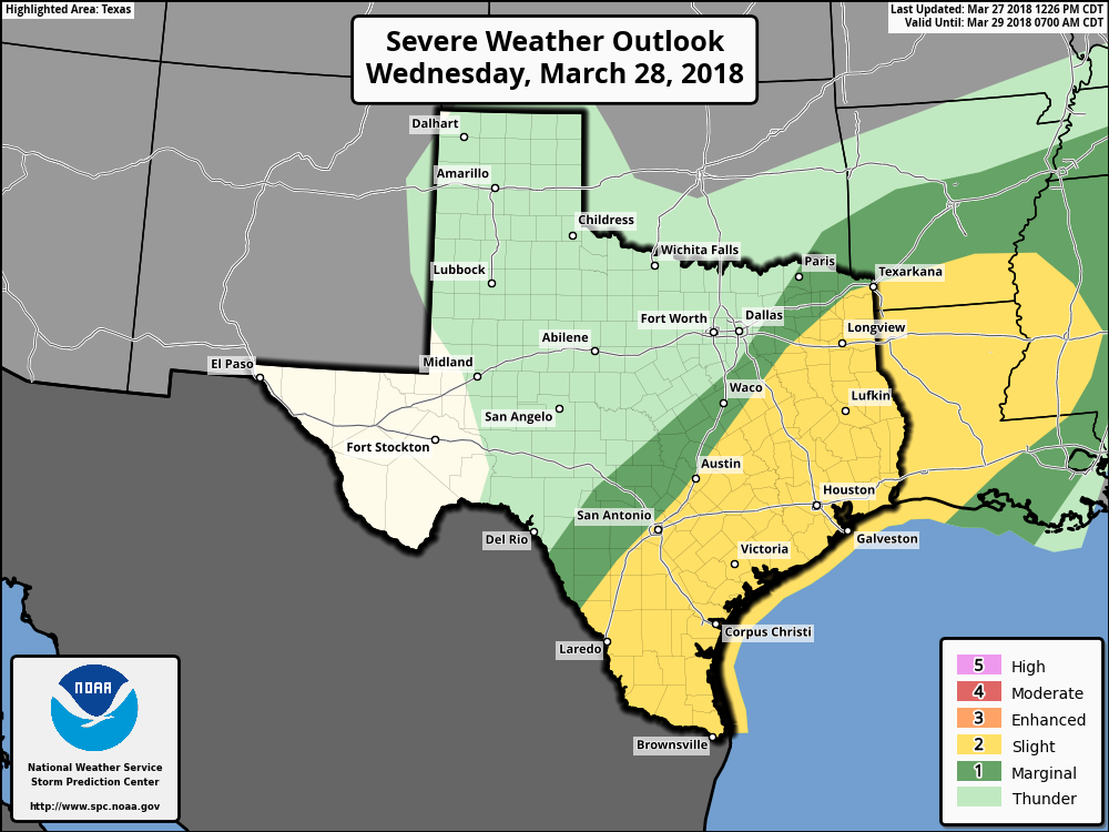
If we can erode the “cap” in the atmosphere tomorrow and get some sunshine to generate some instability, we’ll have a very favorable environment for severe thunderstorms, particularly along and east/south of US-59/I-69. Hail and strong winds are the most likely modes of severe weather, but coastal areas may have a better shot at isolated tornadoes. After pouring over data, it’s not the most aggressive severe weather setup we’ve seen the last couple years, but it’s no slouch either. So we should keep tabs on that tomorrow. In my opinion, this aspect of the forecast is the most difficult to pin down right now.
How much rain? Flooding?
Eric’s mention of 1-3 inches from this morning should hold on average. Some areas could see 3-5 inches of rain or even a little more. Again, this would primarily become an issue tomorrow night.
So will we see flooding? I think some folks were surprised by the issuance of a Flash Flood Watch today. But honestly, we kind of expected it. This is the right setup for a fairly classic lower-end Houston flash flooding event. We still think bayous and creeks should be able to handle the volume and intensity of the rainfall tomorrow. They will likely rise, but most should remain in their banks. We do think street flooding is a good bet in the usual trouble spots over a large chunk of the region tomorrow night. If you’re working the night shift or returning home from the evening, be extra cautious in the dark, when flooded roads are more difficult to see, especially if your travels take you along roads that typically pond or flood during heavy rain.
Rains are still on track to taper off from northwest to southeast late tomorrow night and early Thursday. Eric’s got you covered in the AM.
I’m heading to San Antonio tomorrow morning and returning late in the afternoon. How much should I be worried about encountering flooding?
Is this a classic Nor’wester blowing in? The streets will be a-flowin’ yellow with the flower dust washing to sea.
Thank you for the update. Hope all the pollen and leaves that have accumulated on the ground recently don’t cause trouble with drainage
Just so this blows through by Easter. We need the money at church….
You guys are my go-to source for future weather events! I work in a school, and parents are so influenced by sensationalized reports that they are asking if the school will be closed before we even know that anything is happening! Thank you for your down-to-earth, non-sensationalized reports. You help us to divert the hysteria that comes from reports that are crafted to make news!
Great job as always! By looks of your email, appears we should be ok to make a run up to Blinn – leaving around around 9:00 ish -Thursday morning for a college visit?
Love you guys! Thanks for giving me some reality to focus on.
Looking at the National Weather Service hourly forecast for an area near IAH, they predict the heaviest rain from 1PM-7PM tomorrow.
https://forecast.weather.gov/MapClick.php?lat=30&lon=-95.37&unit=0&lg=english&FcstType=graphical
Thank you so much for the non hype in your forecasts! You have once again calmed my nerves.
Other forecasters sometimes forget that when you mention flooding that a large portion of the area goes into panic mode-once your home floods one time you never lose that anxiety. Thank you for just giving the facts without the drama. You are my go to weather report. Thanks again!
Thanks for keeping us updated. The rain will be welcome. I will keep my weather eyes open on my way home tomorrow evening.
Pet peeve: that’s “poring over” (to pore) not “pouring over”.
Not from Houston, what are the usual “trouble spots” around the city that are susceptible to street flooding in low-level flash floods?
Hi Mitchell,
Typical spots are the streets that run below highway overpasses. Examples include:
– Elgin under I-45 South (Gulf Freeway) by U of H.
– Allen Parkway where it dips down for an overpass (runs parallel with south bank of Buffalo Bayou)
– the notorious ramp from eastbound Westpark tollway that bends north towards the Galleria.
For these rain/flood situations, these two websites will be helpful if you are in Harris County:
– Transtar – http://traffic.houstontranstar.org/layers/ – base map, note the other features also available here.
– Harris County Flood Warning System – https://www.harriscountyfws.org – rain gauge data for spots within the county
And, of course, Space City Wx!