Last night Matt provided a solid overview of the reasoning behind Houston’s flash flood watch for Wednesday, and truthfully not much has changed. Wednesday and (especially, we think) Wednesday night have the potential for widespread, heavy rainfall with possibly some severe thunderstorms. We’re not expecting anything too extreme, rain-wise, but some street flooding is possible later tonight.
Wednesday
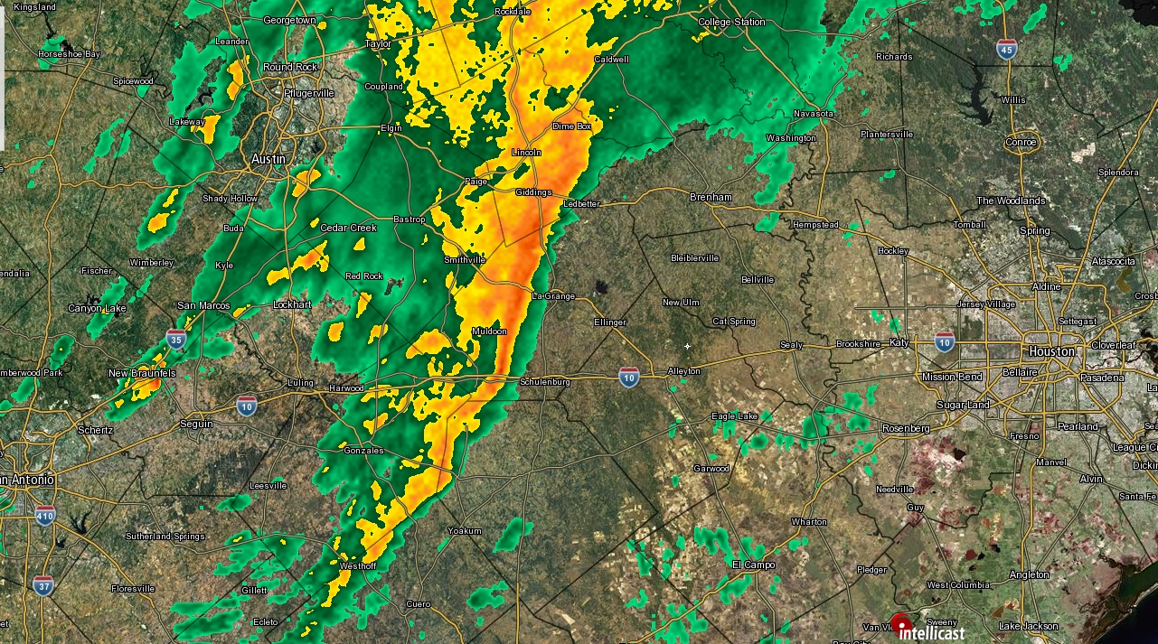
The big question for today is timing. As of about 7am, a fairly robust line of strong rain showers extends along a line almost half way between San Antonio at Houston. It’s not clear when the bulk of the rainfall will arrive. It could be as early as just before noon for western parts of the city, but not until afternoon, or even evening for most of the city. (Note: If you haven’t seen much or any rain by sunset, it doesn’t mean that the forecast is a bust, or the rain “missed” us. Hold on.) We’ll be watching closely, and update this site as necessary. Highs today should reach about 80 degrees under mostly cloudy skies.
Wednesday night
Sometime later tonight, probably about 9 to 11 pm, the forecast models move a boundary into the Houston region, and this should serve as a focusing point for heavy rainfall between that point and perhaps 2 to 4am on Thursday morning. This is the period during which we think the heaviest rain showers will move into Houston, along with the potential for some inclement weather like hail. Most of the area will probably see 1 to 3 inches of rain, but depending on where this boundary sets up—perhaps along the US-59 corridor, perhaps closer to the coast—we could see higher amounts than this. Either way, if you’re a light sleeper, thunder and lightning will probably wake you at some point tonight.

Thursday
This boundary should move offshore sometime on Thursday morning, bringing an end to the rainfall, hopefully before the morning commute really gets going. Skies should clear up on Thursday afternoon, with highs rising to around 80 degrees.
Friday and Saturday
As advertised, the outlook for Friday and Saturday remains exceptional, with highs near or at 80 degrees, sunny skies, drier air, and cool nights with lows around 60 in Houston, and cooler to the north while a bit warmer right on the coast.
Easter Sunday
Easter looks nice, too, with highs around 80 degrees, partly to mostly sunny skies, and a touch more humidity as the onshore flow resumes. Rain chances are essentially zero.
Next week
The forecast for next week isn’t entirely clear, but at this time, I think we’ll see a bit warmer weather, with highs in the low 80s, for the most part, and lows in the 60s and 70s. Rain shouldn’t be much of an issue before Wednesday, and perhaps not even by then.
“perhaps 2 to 4pm on Thursday morning”
Small typo, but I think “am” was meant here.
When you say “2 to 4pm Thursday morning”, did you really mean to say 2 to 4 AM Thursday morning?
“Sometime later tonight, probably about 9 to 11 pm, the forecast models move a boundary into the Houston region, and this should serve as a focusing point for heavy rainfall between that point and perhaps 2 to 4pm on Thursday morning.”
Do you meant 2-4am?
Yes, sorry about that.
So is it safe to assume no hail during the daytime? Say until at least 7pm?
I think so, yes, at least for the city of Houston limits.
The severe part of this storm with the hail and high winds was initially supposed to move through in the afternoon/evening today, but not that part of it is set to move through overnight? UGH…..nothing more annoying than middle of the night severe weather. Shades of those tornado-filled Harvey nights. Hopefully it’s not too severe in the Humble/Kingwood area tonight.
Sometime later tonight, probably about 9 to 11 pm, the forecast models move a boundary into the Houston region, and this should serve as a focusing point for heavy rainfall between that point and perhaps 2 to 4pm on Thursday morning.
guess you meant “2 to 4am” on Thursday morning, — that the wee hours of Thursday are when we are likely to get most of the rain from this event in metro Houston?
National weather service still has the bulk of the rain falling between 1PM and 7PM Wed. (for the area near IAH), though their estimate has fallen from 1.43″ to 1.06″ for that time period. NWS has only 1/4″ forecast for the early morning on Thursday.
https://forecast.weather.gov/MapClick.php?lat=30&lon=-95.37&unit=0&lg=english&FcstType=graphical
This morning it seems the Brenham/Navasota area is getting pummeled but the rain is making very little progress south, just hanging in that area for the past 3 hours (7AM-10AM).
Did you mean to say 2-4AM? Just kidding I’m actually reading this at 10AM and it looks fine, but I’m guessing you made a typo earlier and got corrected 5 times.
Still fairly bright down at the bay this morning…. actually had to put on the sunshades on the way to work as the sun was peaking through….. Maybe, just maybe…. it won’t be so bad…. but I do need the pollen washed off my driveway!! It looks like a yellow carpet! LOL LOL
Fingers crossed April 7th turns out to be a nice day. It’s my little ones 1st birthday and we will be celebrating in our backyard. Nervous it might be a wash out.