Earlier, Matt called attention to the potential for very heavy rainfall tonight from Tropical Storm Harvey, which is drifting east-northeast between San Antonio and Houston. Unfortunately this is exactly what is happening in the Houston metro area. Now is the time to get off the roads, get to your residence, and wait out a potentially long night of flooding.
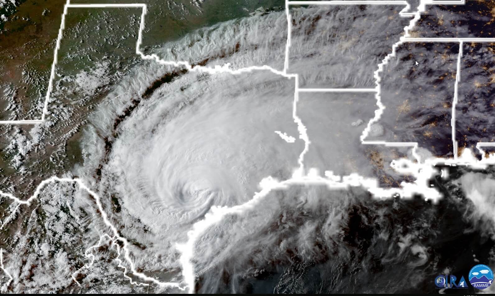
Before jumping to the forecast, we’ve had some questions about why Harvey can maintain its strength and rainfall generating potential a full 24 hours after making landfall along the Texas coast. The following satellite photo, taken by NOAA’s GOES-16 satellite at sunset tonight, tells the story. We have a vigorous low-pressure center inland, but it remains near enough to the Gulf of Mexico to pull copious amounts of moisture into the state.
Rainfall rates
Beginning at about 7:00 pm a large feeder band began moving into the Houston area, and it has brought an impressive amount of rainfall in a short period of time. Some areas near Waller, northwest of Houston, and Stafford, southwest of Houston, have seen rainfall rates of 4 inches per hour during the last hour. That is about twice the carrying capacity of most bayous in the Houston area, and we have started to see flooding along some nearby bayous. We are already seeing deep street flooding in parts of western central Harris County, near Interstate 10 and the Sam Houston Tollway.
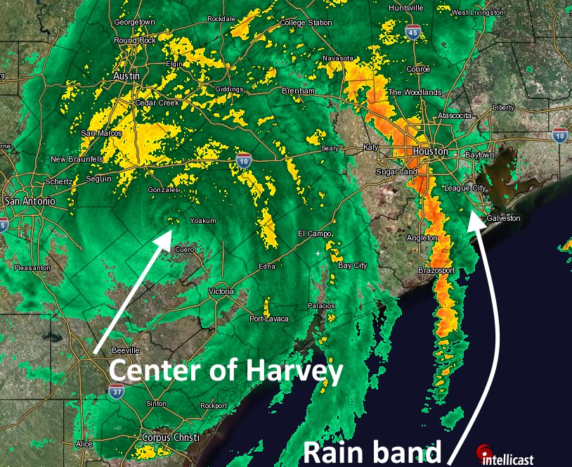
Here’s a look at the rainfall band’s position at around 9pm tonight. You will note the main feeder band extends over the Gulf of Mexico, from which it is pulling moisture into Houston. Additionally, a second rain band near El Campo and Bay City appears to be strengthening, and will move through Houston later this evening.
High resolution models (which are run frequently) continue to show high rainfall totals tonight and into Sunday morning, with widespread accumulations of 3 to 6 inches, and some locations receiving in excess of 10 inches. On top of the rainfall, we continue to see indications of tornadoes on the radar. As Matt suggested, now would be a good time to make sure you have your mobile device emergency alerts notification set to “On” tonight.
We remain concerned about the potential for flooding in the Houston region tonight, and will do our best to keep you apprised of the situation.
Posted by Eric at 9:10pm CT on Saturday

Thanks again for another useful update. For Fort Bend County – Greatwood/New Territory area – should we expect tornado warnings throughout the whole night again? Thanks!
I have a question. Harvey has been moving ENE today, are you confident it’s still going to loop around south?
I have the same question
Thank you very much for updating us. Is there any indication when people that left town will know if they should return?
Eric, 14.5 inches (total) so far here in Sugar Land, Hwy 6 @ Dulles Ave.
That’s where I am! Are you using your own rain gauge? If not, which website? Thanks!
Thanks. I keep sending these on to family and friends.
Same question as I live at Dulles & Lexington. Where did you get this figure?
Thank you, Eric. Loyal to you for 9 years and you continually dedicate yourself to our city. You and Matt are appreciated.
Thank you for staying with me, Lesley. Our coverage is only going to improve.
Improve? It is already far superior to anything else. I cannot thank you enough. I pray you and Matt will get some rest. You’ve made a weather nerd of me.
Here in 77095 the rainfall rate is 3.75 per hour. The band seems to want to move east but just doesn’t seem to be able to make it. Up to 6″ for the day.
Here’s something I have been wondering: If you look at harrisfws.org (which is a great site, by the way) — why does Cypress Creek have so few gauges west of US 290? Not only are there a lot of residents in Bridgeland, but Cypress Creek has a huge fetch area out there, and I would think it would help predict levels downstream.
Thanks for being my family’s go-to source for weather info!
Thank you guys, it’s hitting Clear Lake now. Great job keeping us in the loop
We are at Briar Forest and Dairy Ashford – and our street is now a lake. It’s not getting into any of the house … at this point. The neighbor’s lab of course is loving it.
Thanks for the info on that location! Do you have electricity?
Lorraine,
How is the flooding at Briar Forest/Dairy Forest today?
Eric, what are your thoughts on the last track model guidance? Does the “dying in the Rio” scenario look more likely?
Thanks for keeping us informed, Eric. I’d say Stafford is more southwest of Houston, not southeast, though.
We’re finally going to getting a break in the rain, just past Wilcrest on the west side. But I see from Eric’s tweet another band is following. The street outside my house is rising water.
I’m in Rivers Edge in Richmond and have recorded over 15.5″ since yesterday, and over 11″ just today since midnight.
The weather alerts…. yeah. We have gotten more than 30 emergency weather alerts through our mobile devices in the past 16 hours, and NONE of them apply to our area. What’s worse is our stupid home security panel also screams weather alerts at us, so we’re hearing it twice. It’s getting to be like a Boy Who Cried Wolf scenario. After so many alerts that don’t apply, it’s getting to be where nobody even reacts when the alerts go off.
Is there a way to get a more targeted emergency alert? I mean, “Tornado Warning in HARRIS COUNTY is a bit vague, don’t you think?
We lived in Oklahoma City for five years, and in Wichita Falls for three. Tornadoes are a regular part of life there, but we NEVER got emergency alerts that didn’t apply to where we lived. Why doesn’t that happen in Houston???
Thanks for your blog. It helps keep things in perspective. Stay safe!
Mari,
Have had a similar experience. Use your favorite search engine to look for “weather radios that have selective alerts.” There are a number of these available.
It has to be something with your system. While I have seen all the asked on Twitter or 4 phones only go off when they apply to us. At one point half our neighborhood was in a tornado warning but we weren’t so our phones don’t go off.
What’s the chance that this clears out over 45 tomorrow? I am in Dallas and need to drive home to League City. Worth a shot during the day tomorrow or too risky? How weak is Harvey supposed to get?
Eric, what if Harvey NEVER moves? What if he hangs around all the way to Sept. 30?
I’d love to hear your insight on this: http://fbcoem.org/fort-bend-county-issues-barker-reservoir-advisory-condado-de-fort-bend-anuncia-una-alerta-para-el-barker-reservoir/
Water overflowing ditches. About a foot in the yard and 6″ on the street. 700 block of Rutland in Houston Heights. Sure hope the rain moves away long enough for run off.
Eric, you and Matt and Braniff and this site are a national treasure. We have also been following you since your Chronicle days. I wanted to send you a pic of the empty Pop Tarts shelves at Walmart today… surely your handiwork! 🙂 Thank you all for everything that you do!
11:15 pm Hobby Airport reporting that the arrival area (pickup/dropoff) is underwater.
Thank you for sharing that. A friend and I are due to fly home via SWA/Hobby on Tuesday. Many questions about whether that will happen or not. Glad to find this site…staying tuned from Denver.
😉
Quite a bit of street flooding in Katy near Morton Rd, but so far the recent upgrades to that road have done a great job.
My question is about the status of Addicks and Barker reservoirs. Is there any info on when they will reach capacity, and need to begin releasing water?