Quick note to lead: A Tornado Watch is posted for the entire area through 1 AM. We’ve just had numerous reports of confirmed tornadoes in northwest Harris County. We’ve had multiple other confirmed tornadoes since last night. While our focus remains on flooding, this tornado threat is a serious concern also. Make sure you have a weather radio or have the emergency notifications setting switched to “on” on your mobile device to get warnings for your location through tonight, as periodic tornadoes will be possible throughout the region.
Working 24×7 to keep you safe during #Harvey. These are just the 67 Tornado Warnings issued since yesterday morning! https://t.co/9Z3PvDi19a pic.twitter.com/0Yf9GTsJ6j
— National Weather Service (@NWS) August 26, 2017
Tropical Storm Harvey continues to explore Victoria and the Golden Crescent of Texas this evening. The center as of 5 PM was near Cuero in DeWitt County. Over the last several hours, Harvey has assumed a bit of an eastward drift. This has been fairly well captured on most weather models, and it’s why I think the most critical part of this storm’s legacy in Houston will play out over the next 18-24 hours. Let me explain.
Since about Wednesday or Thursday, it appeared that Harvey’s closest approach to Houston as a moderate tropical storm would be late tonight into Sunday before it drifted back west and south and further weakened. Though it would continue flinging periods of heavy rain our way, the core would be mostly out of the picture after tomorrow. Some of our shorter-term and highest resolution weather models are suggesting that Harvey’s center drifts a little closer to Houston tonight, bringing some of that core to the western part of the city, while continued onshore flow of moisture helps new rain and storms to form.
This would mean a major uptick in rainfall across much of the Houston area tonight. We’ve been fortunate so far for the most part. Bayous have filled, streets have flooded, but much of it has been manageable by our fairly rigorous rainfall standards here in Houston.

Tonight & Sunday Morning
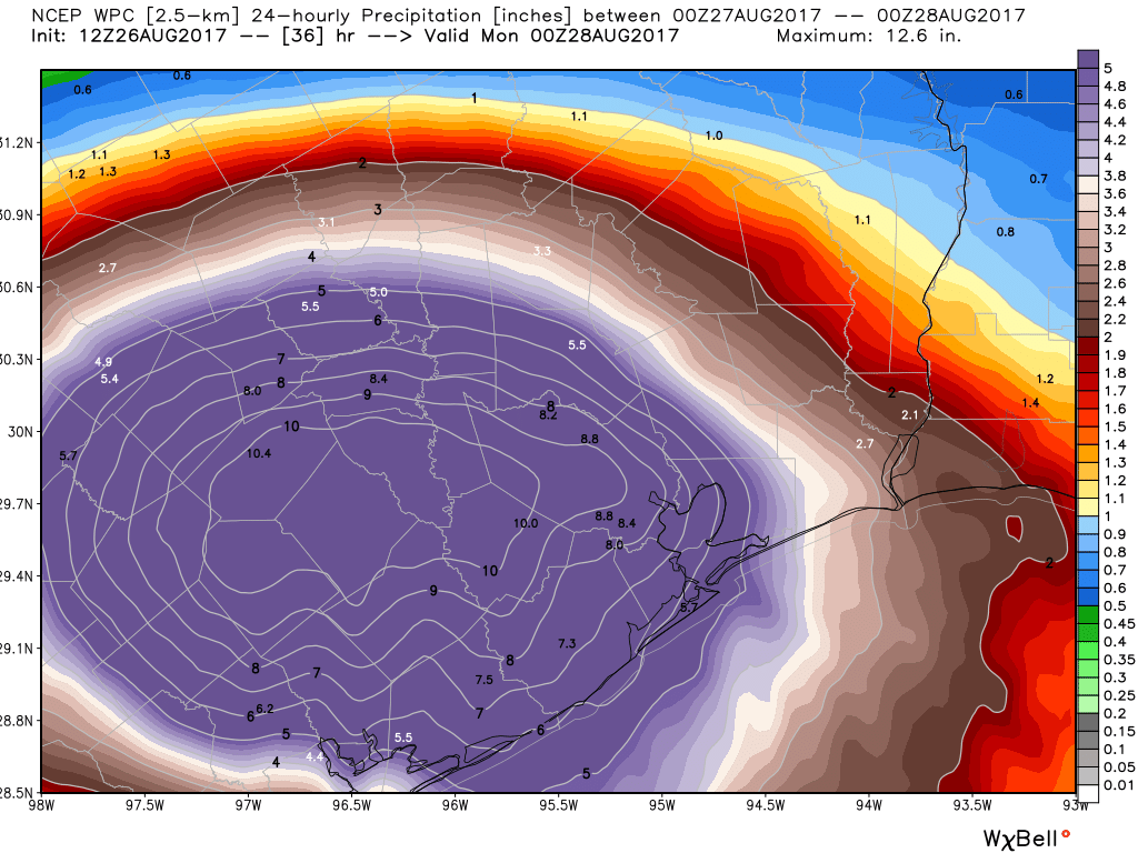
Looking at the radar loop above, you can see a bit of an increase in rain around Houston and a slow drift east of the band on the east side of Harvey’s center. As we go into tonight, we expect heavy rain to redevelop over most of the metro area. On average, based on the latest weather model data, I would expect most of the region to see an additional 3-6″ of rain tonight. But, I expect a pocket or two of 6-12″ with higher amounts possible.
Some questions still: Does Harvey keep drifting east or does it shift back west or south? That could realign the heaviest rain. Alternatively and worse, does Harvey drift a little closer and just stop, leaving the heavy rain in place all night and tomorrow morning? Does the dry air that’s helped keep many areas south and west of Houston quiet today hold longer than models expect? If so, rain totals get cut down. We have a lot to consider, and this is a very fluid (sorry, pun) situation we need to continue observing tonight to really understand how bad (or less bad) it will be.
Here’s the deal: If the rainfall tonight underperforms around Houston, that’s wonderful news. That also helps give us some extra breathing room with the subsequent rains that will hit us next week (no big forecast changes on that this afternoon, just FYI). But if the rainfall tonight achieves its full potential or overshoots that, we are going to have absolutely major problems around the area on Sunday morning. The goalposts are wide. Let’s just keep an eye on things tonight and see how it evolves. We should know more later this evening, and conveniently, Eric should have a post around 10 PM, give or take. Meanwhile, stay safe.
Posted at 5:10 PM Saturday by Matt
Thank you, my foul weather friends!
Y’all are the absolute best!
Thank you guys for all the work. I am really enjoying your blog I found it through another FB friend. You guys stay safe.
I thought that the storm was already here. What was last night?
How much of the blog posts do you read?
It came ashore last night but it’s going to hang around for a couple of days.
Good job and God bless you guys. Thanks so much.
Live in the loop and haven’t seen more than 3 drops of rain! Still waiting to see if this storm was all hype
helen, this storm is absolutely not “all hype.” For those of us not severely affected (so far), it’s been a good exercise in abundance of caution. For those less lucky, it’s been a horror.
depends on where you live. friends in Richmond have had to have 2 very large trees removed from their house this afternoon and a gaping hole covered before more rain tonight. Tornado touching down near 290 & 99.
No offense, but there are a LOT of folks in the larger storm area for whom the ‘hype’ is all too real.
Just 30 miles west of downtown is getting it in the teeth. Evacuations in Rosenberg.
“All hype” Really?? Just because you haven’t seen “3 drops of rain” Harvey didn’t happen?
According to https://www.harriscountyfws.org/ inside the loop has seen 3+ inches of rain.
What an ignorant comment…
He’s in the loop. Needs to look over the horizon to see what’s happening. Harvey may be bringing more than 3 drops a bit closer…
Live in Austin. Trust me—no, it was not all hype. This time last night, we still had inch-wide cracks in the soil. Now, it’s saturated. Limbs occasionally come down, and the wind and bands of rain just keep trucking through. And I am grateful—we have it easy, all things considered.
And this is the longest the temperatures have been below 85 since, oh, March. 🙂
Stay safe and dry!
Austin here as well. We have many branches down and have an over/under on how many trees we’ll partially/fully lose in our yard. It’s been gusting all day with the tropical rain pattern that comes in sheets, then pauses. Rinse, repeat. 5.5″ and no let up.
In the last two hours our lights have flickered multiple times. Like you say, these are first class problems compared to the folks south of us.
be glad you aren’t one of the families whose been affected by the tornadoes in cypress or other outer loop communities. it’s more than Hype dear. I’m live in the med center and although we aren’t flooding the rain is here. And there’s more to come
Agreed, they really haven’t mentioned the inner loop on the local weather at all. We are not scary enough I guess
Patience, Grasshopper. You’ll get your three drops of rain and then some.
Helen. Helen. Helen. One year later and I am laughing out loud at your post. Now you know…
Thank you again for all the work on this site every day. SpaceCityWeather is the one site we can look to for the best and most realistic view of what is happening with Houston’s weather. That’s true every day, but is particularly valuable at a time like this. Thank you again.
I second that sentiment in it’s entirety. Thanks Eric and Matt!
Thanks guys, great info as always. It’s been an interesting day in west loop Houston; very little rain at all, even some patches of sun. I’m hopeful that the rain will continue to underperform. Also, the NOAA maps seem to indicate that the storm is going to head north, more toward Austin/Bryan than toward H-town.
http://www.nhc.noaa.gov/refresh/graphics_at4+shtml/212527.shtml?gm_track#contents
Is that a correct reading of this map? Does that storm path seem plausible to you guys?
Thanks for the updates!!
Matt… thanks to you and Eric.. trying to keep us sane with just the FACTS!
What dynamic could/would cause the continuous rainfall to get heavier? Not to take anything lightly, but even though we’ve had fairly continuous rainfall since late last night, it’s been light to moderate, and has drained quickly. What would cause that to change?
Rick K.
I’ve grown up in Houston and even with Google’s help have no idea what you mean by “Golden Crescent of Texas”
The Golden Crescent refers to Victoria County and its 6 surrounding counties.
It’s a region of counties around Victoria, according to Wikipedia: https://en.m.wikipedia.org/wiki/Golden_Crescent_Regional_Planning_Commission
I suffer from anxiety. Watching the news makes it worse, im thankful i have this site to rely on.
Thanks guys for all that you do.
Thank u. Been subscribed for last month after a tip from my son. What a fantastic job and your rhetoric as others have noted is very much appreciated. no hype just the facts as best you can understand.
What an absolute delight NOT to read the words DEVASTATING or UNPRECEDENTED in a weather related story!! Many thanks. Will follow on.quiet here in Galveston
It’s a bit frustrating that even high-quality reporting like this site’s doesn’t seem to account for the effect of the rain bands. It looks like most of Houston, and certainly the area in the NW where I live has gotten off easy today (not counting the Cypress tornado just a few miles away). We’ve only had an inch or so since 7am, with some 10 or 20-minute intervals of heavy showers. But areas east and west of Harris County appear to have been under heavy rain all day.
If you look carefully, you can see the rainband effects in the hour-by-hour rainfall sequences, but when the totals are averaged over a day or so, the lateral drift in the bands washes out the great variability between whats going on under a band and whats going on between them. You can even see 3 distinct bands of alerts in the chart of 67 tornado warnings.
There’s so much more going on in these storms than is shown by tracks of centers, and I’m sure the models capture much of those details. It would be neat if someone could figure out how to make those details more visible.
p.s. an editorial note: One of the more annoying journalist-isms in long form stories is the phrase “Let me explain.” Y’all have used that in two posts in a row today. Maybe you could replace it by “Here’s why:” for example, if you feel compelled to apologize for going into more depth with an explanation.
The models are very low resolution when it comes to specific locations.
Get your own weather station. I have a Davis Vantage 2. Here in 77095 and we have had 3.5″ since 7am. At 2:25 we had a 28mph gust. You can also go to https://www.harriscountyfws.org/ to see rainfall totals at multiple recording stations.
Weather Underground does a pretty good job of providing data for area code resolution. You can also access various weather stations within your area to fill in those gaps. Their Wundermap is excellent for seeing Doppler right down to your house.
As I write this the next rain band appears stalled just west of us. Not sure any model can predict this level of precision.
GMcK, you are a douchebag. Let me explain: making obnoxious comments about “journalist-isms” on a free site that is doing a great service to those of us in the Houston area in a time of need is really low. Get your head out of your ass.
Yep.
Let me explain why we use let me explain …
No, seriously. Sometimes we are writing these posts very quickly, after synthesizing a lot of information. And, you know, in the hurry to get these published, sometimes we fall back on writing ticks like this. I’d rather the quality of writing suffer, a little, in the interest of accurate and more timely information.
Thank you for your updates! My dear Fulgencio and I have only taken around five inches so far which has been nothing of concern so far. I did have to comfort him in his crying today and remind him not to be worried since we know we have the ability to regularly handle eight inches with no problem. I will say we are both a bit frightened if we will be able to deal with something like twelve or fifteen inches though which is something neither of us has ever experienced.
Naughty naughty…
Did you mean to post this on this website?
Eric, is it true that there’s a severe fuel shortage in Houston due to Harvey?
This is not true. There is plenty of gasoline in Katy, despite an article at the Chron.com website that states they found up to 20 stations from Katy to Houston without gasoline. This is fear-mongering for clicks.
Thank you for the detailed updates, you guys have been a godsend. Here’s hoping that the rainfall stays light/moderate!
“Since about Wednesday or Thursday, it appeared that Harvey’s closest approach to Houston as a moderate tropical storm would be late tonight into Sunday before it drifted back west and south and further weakened.”
Well, that sentence belies much of what you have written on this blog and runs counter to the NHC forecast track from Friday, which had Harvey, still at tropical storm strength, centered just south of The Woodlands on Wednesday, four days from now. Look–uncertainty is understandable, but rewriting history is not.
Whoa, it’s not “rewriting history” when you are predicting likely outcomes based on computer models. “Revising the forecast” is probably a more accurate term. It’s not history until after is happens. And we’re still a few days from Wednesday.
Eric, I’m a compulsive shopper and I’m scared……will all shipments of consumer goods, fuel and food just come to a halt because of this rain? Will shortages and outages be the rule around here ‘stead of the exception?
Best time/day to drive from Dallas back home???
Around 4 hours from when you need to get here…
Eric, I’ve been watching NOAA weather radar, and from what I’m seeing, the eye of Harvey is clearly moving to the east. I’d put over the city of Houston sometime during the overnight period. Your thoughts?
I see NOAA’s maps indicating the complete opposite: that the storm is going to move SW toward the coast from now till Monday afternoon, then moving due north toward Austin/Bryan:
http://www.nhc.noaa.gov/refresh/graphics_at4+shtml/212527.shtml?cone#contents
Also, windy.com indicates the eye of the storm is over Cuero TX right now, that’s 146 miles from Houston. Last I saw Harvey was moving at 6 mph; no way it could cover that distance in a few hours, even if it sped up substantially.
Eric and Matt are the experts, so I’ll leave it to them, but I don’t see any evidence the eye of the storm is headed straight for Houston.
Thank you guys for all your hard work over these past few days! You guys are the ones I rely on not to overblow or understate the situation.
Since 4/25/2017 around 2 pm until 8:00 pm 4/26/2017, I’ve dumped 9.4″ of rain from my guage. The rain guage overflowed last night (6″+) so I have no true idea how much we’ve had out by the Grand Parkway, unincorporated Fort Bend County. So far things are draining ok.
We just had 2″ of rsin in a downpour in 30 minutes (4/26/2017) just before 8:00 pm and it’s still raining.
You guys rock. Someone even mentioned you on CNN.
Why do these heavy rain events in Houston always seem to occur at night?
So SW Houston @ Braeswood & Hillcroft is getting hit as hard as 2016 or 2017, if not harder. The radar looks quite ominous for a training set of storms to dump over capacity rain for quite some time into the Brays bayou watershed.
Unfortunately, we agree.
Mark the calendar,lol.
My neighborhood is likely suffering its 3rd flood event in just over 3 years.
The previous 2 were preventable with basic maintenance and engineering repairs.
This one may be “unavoidable” but I doubt it.
20+ years of Houston Mayoral negligence and HCFCD lip service are hard to undo quickly.
The infrastructure is aging more every day, the lack of serious maintenance, much less preventative measures, is worse over time as well.
Widening Brats Bayou is still years behind schedule.
How to apply enough pressure to force a very reluctant government to do basic work when it is so much more fun to do other things?
In terms of rainfall it doesn’t matter one bit.
Thanks so much for this site. Concerned about League City…..