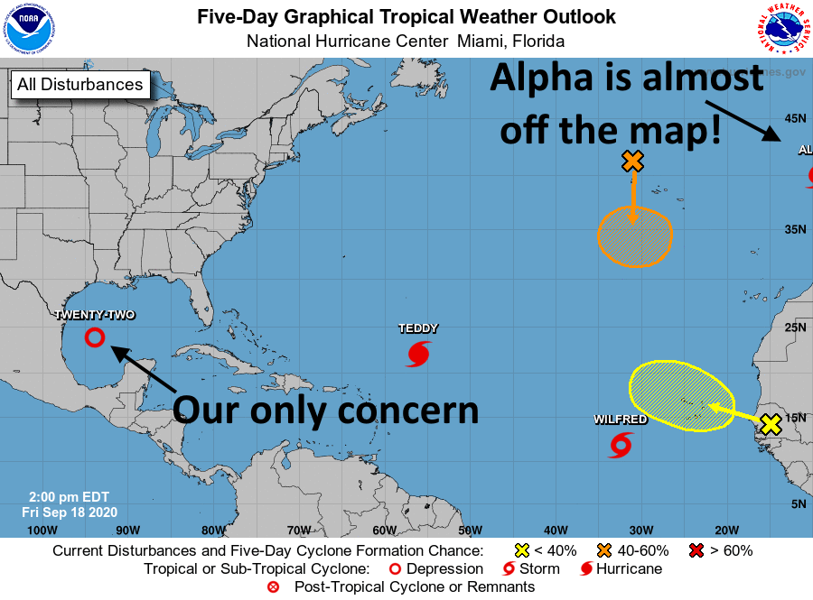
Welcome to another crazy day in the tropics. While we we’ve been waiting for Tropical Depression 22 to strengthen into a tropical storm, a system in the deep tropics became Wilfred this morning. And then, at noon, Subtropical Storm Alpha improbably formed off the coast of Portugal. Neither of these storms remotely concern the Gulf of Mexico, so our focus will remain on the depression that will become—checks notes—Tropical Storm Beta later today.
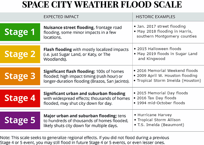
We are issuing our first Flood Scale forecast for this depression, with the caveat that this is subject to change. Simply put, there remains a healthy amount of uncertainty about where the heaviest rains will come over the next five or six days. However, for now, we are calling for a Stage 2 flood for areas south of Interstate 10, and a Stage 1 flood for areas north of Interstate 10. The biggest rainfall risks for Texas are right along the coast, from Brownsville to Galveston.
Now let’s talk track, because that ultimately will determine what happens with the depression’s rainfall.
Where will Beta bend?
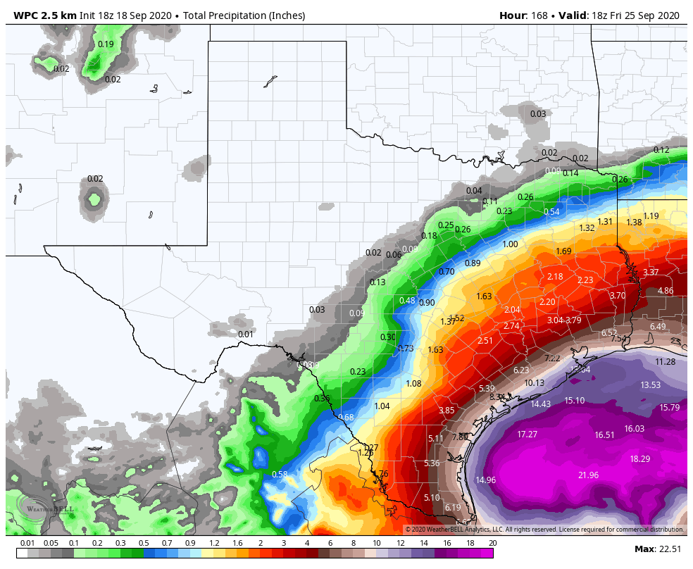
This will be the story of two turns. The following graphic shows the National Hurricane Center’s official forecast track (as of 10am CT Friday) in black. I’ve made several annotations that I want to talk through to help you understand the track forecast and the uncertainties that we’re dealing with.

Alright, so we’re fairly confident in the storm’s track today and tomorrow, when it should run into high pressure associated with the front that has moved through Houston already. This should push the system westward, toward Texas. The big question after this is how far west the storm will get—probably very close to the coast, and perhaps even a little bit inland (I’ve tried to highlight this area with the white rectangle). The storm does its coast-hugging, slow moving routine on Monday. At this time it will produce a lot of rain, but hopefully most of this will fall east of the center, offshore.
The second turn
By around Tuesday, the storm should begin to lift to the north and then northeast, perhaps moving close to the coast (as indicated by the official forecast), or further inland (wetter for Texas) or further offshore (drier). Because we have so little confidence in the track for Tuesday and beyond it’s hard to say how much rainfall we will see in the Houston region. For example, I could envision 5 inches of rain in Galveston, or 20 inches. I could envision 2 inches of rain in Houston, or 8 inches. We’re pretty confident that rain chances will perk up on Sunday, with the really heavy stuff possible from Monday through perhaps Thursday morning. For more precise totals you’re going to have to hang in there with us until we get a better handle on the storm’s track.
Coastal flooding
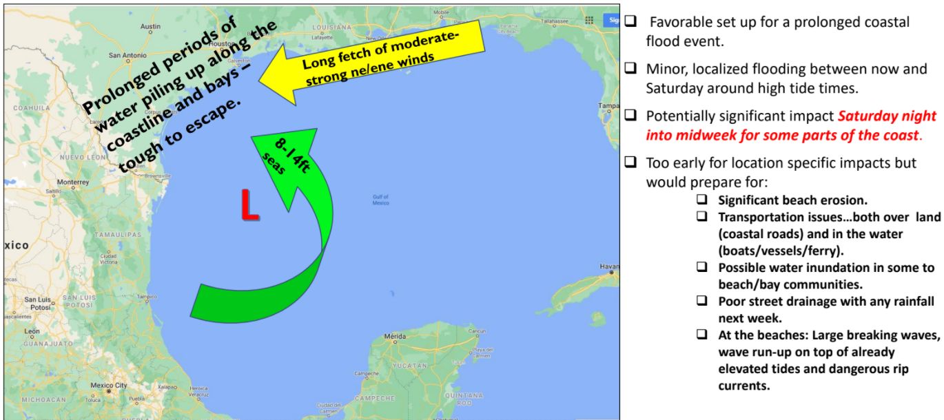
The other issue is coastal flooding. Generally, we anticipate the potential for water levels to rise 1 to 2 feet higher than the region experienced with Hurricane Laura three weeks ago. Waters will start to rise on Saturday, and increase on Sunday. After that any additional rises will depend upon the intensity of the depression—we still think it’s going to become a tropical storm or a Category 1 hurricane at most—and its track. So these hazards are to be determined as well.
That’s all we have for now. Matt will have our next update at 8:30pm CT this evening. By that time Beta probably will have formed. Alas, Beta won’t be a fish storm.

“Alas, Beta won’t be a fish storm”. Nice! 🙂
The forecaster used a “beta blocker” pun in the afternoon advisory, in reference to the ridge that’s expected to steer it to the west. This, after the “Teddy Bears” fiasco earlier this week, and I feel like there was some other shenanigans in their posts from the last couple of days. At least they’re having fun while staying so busy.
What about 20 inches (or more) in Houston?
Hi I love your space city weather flood scale. One request when considering your flood scale can you include in the scale the May 2015 flood in Clear Lake are that flooded many homes? I like to refer to it as “the flood the city forgot”. Thanks and keep up the awesome calm job y’all do of reporting the weather.
I mean, it’s possible? But it seems quite unlikely at this point.
Thanks! Three-time flood victim anxiety here…
I get that it’s nothing to sneeze at, but it sounds like we would be looking at something in the neighborhood of 10 inches over 2.5 days as a worst case scenario (assuming we exceed 8” by 25% and compress into a Tues morning arrival and Thurs noon departure). That doesn’t seem….terrible. Not fun and certainly going to mean a lot of people needing to stay home, avoiding underpasses, and generally keeping the roads clear.
Am I just letting the past leave me too jaded? It just feels like 3” a day should be slow enough for the drainage systems to, even if there are heavy moments.
Are we 100% certain that Alpha will not circle back and come toward Texas? No chance? Just checkin’
Yes, we are.
I guess Portugal was due for a storm.
They get left out alot. They might as well get some craziness too.
Once again thank you for a no BS, rational, assessment. I appreciate your candid admission that you cannot give a high confidence track until the storm develops further. Your presentation and the accompanying graphics are outstanding
You guys are the best!
Tax Day and Harvey flood veteran here just wanting to say I appreciate your flood scale along with your thoughtful, no hype reporting.
Matt and Eric, thank you for the rational assessments of how these crazy storms might move around.
Granted, it’s not really possible to completely accurately pinpoint the path of these things, but I’d much prefer to have a list of rational possibilities than ratings driven hype and panic stirring.
We’re still in hurricane season, so we should all know we still need to be as prepared as possible. The usual: keep the emergency pantry stocked, first aid kit stocked, fuel for the generator, important papers accessible or at least well protected, ample supplies for our pets and accessible simple tools. And, keep those rubber waders handy. This is the Houston area after all. All the usual routine.
But, to be honest I AM SO SICK OF FLOODING and the possibilities of it make my stomach churn.
I do hope however everyone will always keep in mind, people and pets first, possessions last.
“Fish storm”, I had to look that one up. I always learning something new on your site 🤓
Geez imagine running a shipping line in the Atlantic right now. Talk about chum city!
Any idea why NHC would name a storm that originated off the coast of Portugal and have absolutely no impact to the US? Seems like they are trying to pad their hurricane numbers with that one.
World Meteorological Organization names storms.
because the atlantic touches more than just the US….
Hey Eric / Matt
Of course this storm comes while I’m on vacation *eyeroll** Well we’ll be driving back from Panama City FL Thursday morning .. should we wait till Friday?