We will hop right into things today, beginning with our near-term forecast and then jumping into the latest on Tropical Depression 22.
Friday & Saturday
The cold front is through, and we’re on the way to more comfortable weather. Look for a good bit of cloud cover at times today, with perhaps a slight lean toward more sunshine later in the day. Highs should be in the upper-80s today, perhaps a bit cooler in spots, and you’ll notice a bit less humidity as the day wears on.
Clearing commences tonight, and we’ll have a stellar morning Saturday, with lows mostly in the 60s.Look for full sunshine tomorrow in most of the area with highs again in the upper 80s and tolerable humidity, a very nice late summer day. Winds will be noticeable at 10 to 15 mph, with some higher gusts up closer to 20 mph at times, especially on Saturday.
Sunday & beyond: The TD 22 impact
Alright, let’s talk about Tropical Depression 22. We’ll start with what it’s doing now, and then we’ll run through some track scenarios and what impacts those have for the Houston/Galveston areas south to Matagorda.
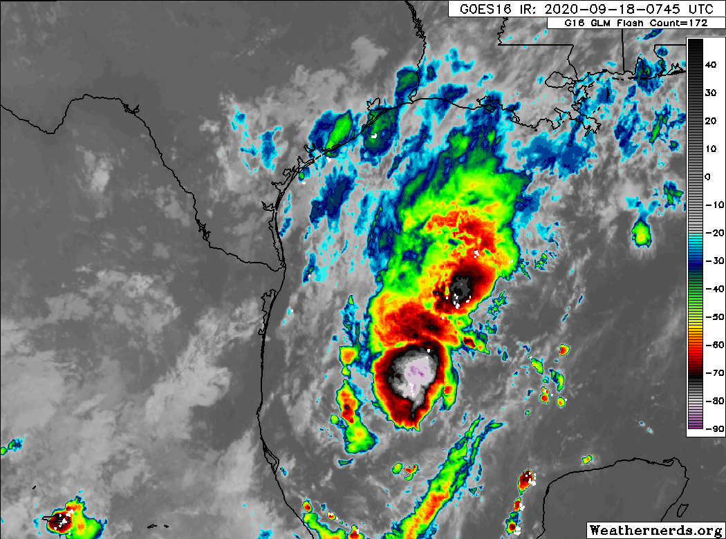
If you look at the satellite loop above, you’ll see that while TD22 certainly has a lot of thunderstorm activity, it lacks a lot of organization. Per the National Hurricane Center (NHC), the center of TD22 is fairly elongated and its motion erratic. Basically, this is still a nascent storm.
Over the next 48 hours, the storm will, broadly, track slowly to the north or north-northeast. The center, which is currently about 250 miles east of the coast of Mexico will likely end up about 250 miles off the coast of Corpus Christi by Sunday morning. We have fairly good confidence in this part of the forecast.
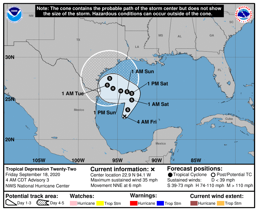
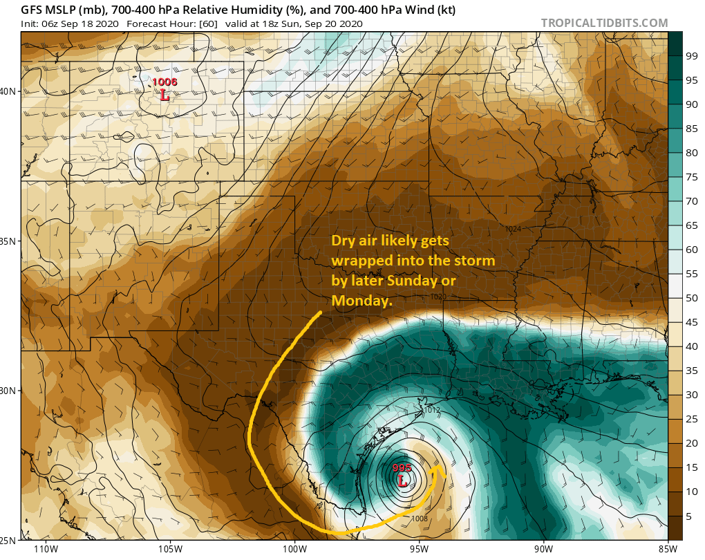
From there, forecast confidence plummets. But we can again at least make some generalizations. The storm should generally, slowly track toward the coast south of Houston on Sunday, Monday, and Tuesday. The NHC brings it up to category 1 hurricane intensity on Sunday and Monday, but even they admit that is at the “top end” of forecast guidance at this time. Assuming it’s Tropical Storm or Hurricane Beta, it will likely begin to weaken after Monday thanks to dry air from our recent cold front being wrapped into the storm.
While we should remain vigilant for any sudden changes in intensification, Eric and I (and most others) will be framing TD22/Beta in terms of a water concern more than wind. This is not Laura. With the storm possibly stalling off Corpus Christi for a time, coastal areas south of Freeport may end up seeing lower-end tropical storm winds for a couple days.
Because this is a slow-moving rainstorm, there will also be temptation to compare it to a certain 2017 storm. This is not Harvey. I don’t want to give people a false sense of security; this storm is a serious concern in its own right, but it is a unique storm that will pose different problems for different places than we saw in other past storms.
TD22 or Beta will likely stall off Corpus for a couple days and then begin to drift northeast out of the area. That process may take a couple days itself, and it’s possible we are not done with this storm until next Wednesday or even Thursday.
Eric laid out three scenarios yesterday, and it appears today that some version of scenario B is most likely. We still don’t know if that track will end up bringing it ashore near Corpus and then up the coast or if it will keep it offshore. Either way, we endorse the NHC forecast map above as being about as good as it gets given the information we’re all looking at right now.
Just to give you a sense of why there’s still uncertainty, here’s a look at the tropical “spaghetti” plot.
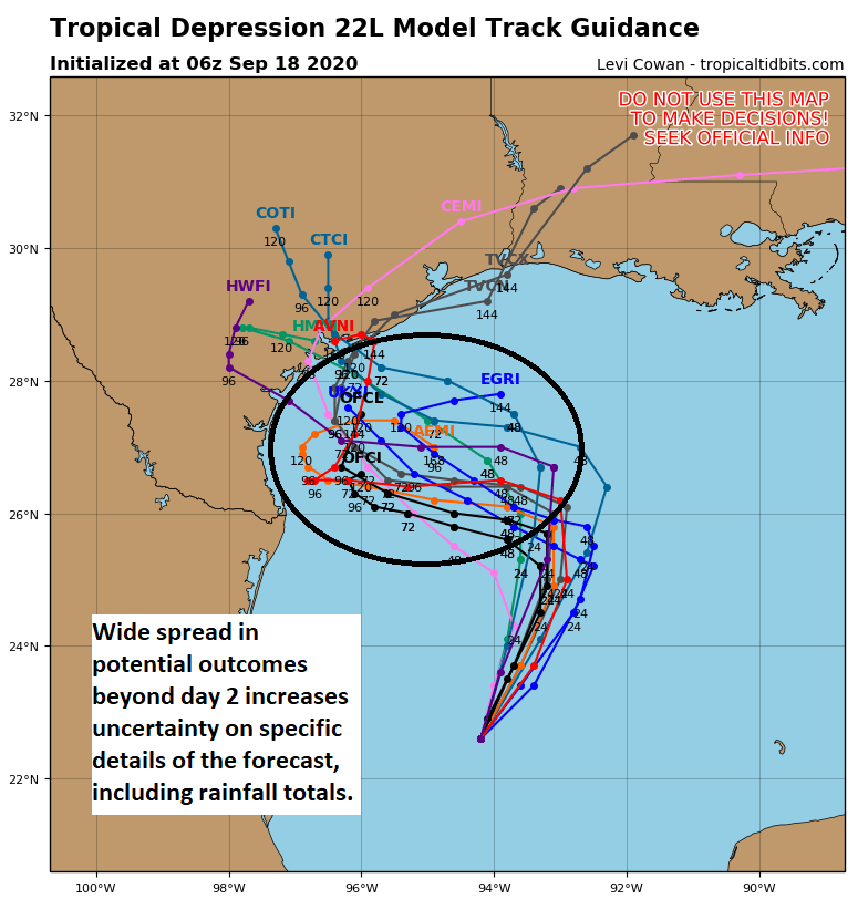
Don’t focus on any individual track here, but the reality is that a number of possibilities exist, each of which could offer a different outcome for the Texas coast. A track to the west approaching the coast near Brownsville will provide a different rainfall outcome than one that comes west closer to Matagorda Bay. And that’s why it’s important to understand that the specific details of this forecast are absolutely subject to potentially considerable change over the next few days.
So what about rainfall? Well, the current forecast is based on the official NHC track. As noted, this can and probably will change for better or worse.
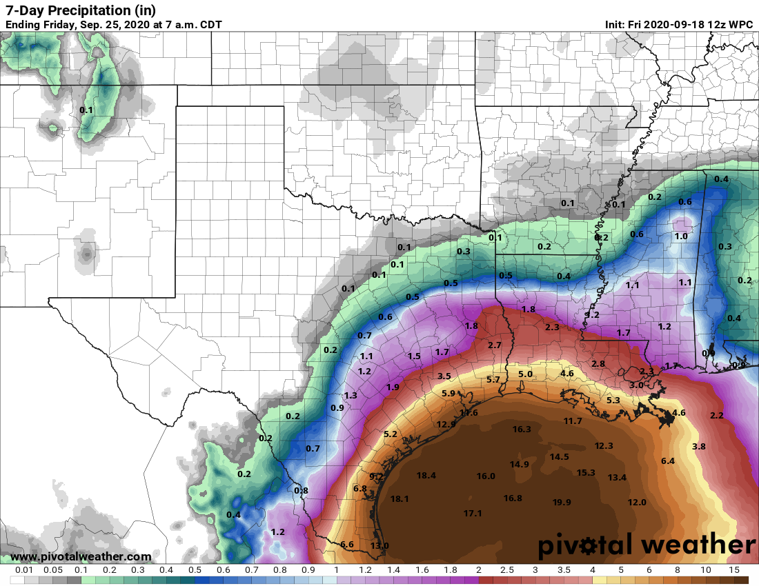
The current rain forecast calls for about 2 to 5 inches for most of the Houston area, escalating to 10 to 15 inches as you get toward Galveston or Freeport. Areas north and west of Houston are currently expected to see 1 to 3″ or so. Spread out over a week, this is probably manageable to some degree for areas south and east of Houston. But much will depend on how intense the rain is and for how long, questions we are unable to answer at this time. But this gives you a good opening bid on what to expect. Again, if the track comes farther north or shifts south, these totals will change.
In addition to the rain, there will be some considerable coastal impacts as well. Days of east or northeast winds and 8 to 15 foot offshore seas will pile water up along the coast, with limited chance for it to drain out substantially. The current expectation is for tides to be 1 to 2 feet higher than those experienced during Laura as early as Sunday. This will cause considerable coastal flooding of low lying roads at high tide, as well as significant beach and dune erosion, especially considering it will likely continue into Monday and Tuesday. Coastal residents should be prepared for issues beginning Sunday and continuing through at least Tuesday. We’ll have more on this as it becomes clearer.
It’s a lot to digest, but hopefully we’ve at least given you a reasonable first call at what to expect here. In terms of timing when the rain will be worst and where we will place this on our flood scale, we’ll try and hammer that out a bit more later today and tomorrow. Right now, expect some rain, possibly heavy each day beginning Sunday and continuing into Wednesday.
Eric will have our next update no later than 2pm CT.

November 30th can’t come soon enough!
Matt, you invoke Ike in 2017, but does this look vaguely Alison-ish?
Too soon.
Vaguely, very vaguely, as even that occurred in a much, much different manner.
Heck of a change in the NHC forecast in 12 hours. North, South, who knows, right? Really hope it stays far enough away to not do damage..
Thanks for your diligence.
Great in depth forecast. We’ll just have to wait and see what happens. Personally I’m not overly concerned. Thank you.
Thank you for ALL you do – for your honesty and humanity – and brilliance. You are such a gift to our community!
That blurb about “2-5 inches for the metro Houston area – then 10 to 15 inches as you get towards Galveston or Freeport” was an eye-opener. Talk about a jump in total rain forecast. Yikes.
Like others have said, I’m both fatigued by too many storms + not really worried about this confused blob o’ rain. But, more importantly, I’m leaving town for a week so feel free to get doused in the meantime. Send my share to El Paso, Lubbock, and Midland.
So if you had a move scheduled in Galveston for Monday morning… you’d reschedule?
Thanks for all y’all do.
Honestly? I wouldn’t reschedule yet if you can wait another day. If this sneaks a bit farther south, it’s feasible you wouldn’t see much rain there on Monday. That’s not the forecast right now, but it could always trend that way in time. But if you have to make a call today? Yeah, I’d probably push it back a week if possible. But obviously that depends on your situation.
By mid September, the chance of tropical storms coming to the Houston area is usually very low. But this is 2020, the Year of Disasters.
Yes, I’m surprised we haven’t been hit by a Cat 5 in Freeport the same day the Yellowstone Mega Caldera explodes and a nearby star goes Supernova.
that would make for a pretty interesting apocalypse
I thought I had forgotten the 100-meter high tsunami created when La Palma Island slips into the Atlantic, then I realized that will only hit the East Coast. No problem here…
Wait….. is that lows in the upper 50s I see in the GFS for Sept 29th? Forget another Cat 1 hurricane, this is news!
Maybe throw some darts at a dart board to figure this out? As Yogi Berra said, “It’s tough to make predictions, especially about the future.”
I’m near Freeport, appreciate the info you give for us folks down here!
We’ve rented a beach house in Galveston through Sunday at noon. Should we be worried about Sunday?
I wouldn’t be too worried about Sunday at this point. May not be a great day there, but I think you’ll be able to get off the island without a ton of heartburn.
Same question but in Corpus. How does that look for leaving Sunday morning?
There may be more issues down there, but I don’t think things will get bad in that area until Sunday afternoon. That said, it may still rain between here (? I am assuming you’re headed back toward Houston) and there. But it would get worse in the afternoon. Subject to change, but that’s what it looks like now.
“I always get a warm fuzzy when the day 5 plot point is still inside the 3 day cone,” said no one in flood prone areas ever.
TS Beta? what happened to Alpha? It’s not on the nhc.noaa.gov site. Wikipedia shows a broken article for it, no news sites are showing it.
Was it a blink and we missed it storm?
It’s a very small subtropical storm off the coast of Portugal that intensified shortly before landfall. It might not even last a full 12 hours at TS strength.
Me this morning:
Keeping an eye on “potential tropical storm Wilfred”
…Wait I spoke too soon.
…Keeping an eye on “potential tropical storm Alpha”
…Oops. No. Huh….well that popped up pretty quick.
…Keeping an eye on “potential tropical storm Beta”
scans the Atlantic suspiciously
Hi Matt. We have a Condo rented in Galveston on Seawall Blvd. Arriving Sun afternoon and leaving Thursday. I’m from Oklahoma not familiar with locations there, can we expect a complete washout or do we have some clear days to look forward to. Thank you.
You may get a few breaks in the rain, but unfortunately it looks like next week is going to be kind of a wash there. I do think swimming is going to be dangerous most of the week due to rough seas/rip currents. And there may be both coastal and rainfall flooding in parts of Galveston. It’s just not a great period. Wish I could offer you better news.
We have a trip to South Padre planned for next Thursday the 24th for the entire following week. Should we still be good to go by then? Thanks for all y’all do.
SPI should be good I think. Most of this will be up near Houston or Louisiana (or so we think) by then. Still subject to change, but sitting here today, I’d have no reservations about going right now.
UUP-DATE.
UUP-DATE.
UUP-DATE.
PATIENCE..PATIENCE..PATIENCE
This is going to develop slowly over several days. Unlikely any significant developments until tomorrow. Other than maybe going to a TS.