Thursday provided some mostly welcome rain for a large swath of the region. For the city of Houston, anywhere from 1 to 3 inches of rain fell. Generally lesser amounts fell to the north and higher amounts to the south.
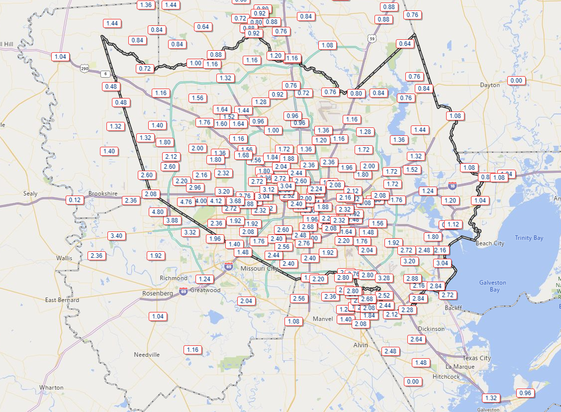
The bullseyes were near Barker Reservoir and out through Cinco Ranch, where 4 to nearly 5 inches of rain was reported on Thursday. Another bullseye was noted from Friendswood through Kemah and San Leon, where 2 to 4 inches generally fell. Dreary weather hangs in today, but a nice weekend awaits.
Today
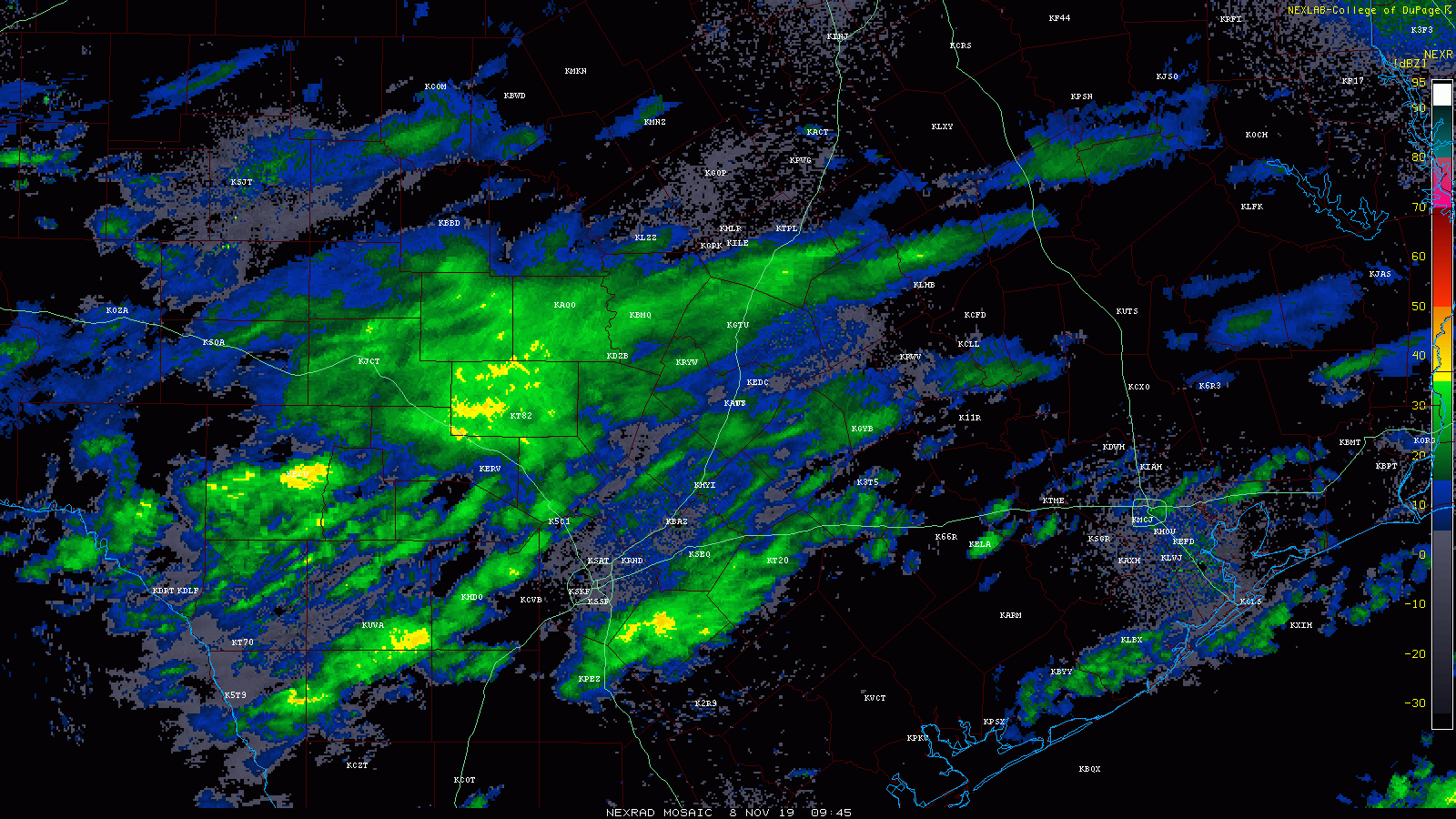
The title of this post includes the word “drearies.” Debate whether or not that’s a real word, but you can guess what it means. Look for clouds all day today. In addition, the region should see periods of light rain or drizzle throughout the day. A period of steadier rain is possible for a time this morning or afternoon. You can see some of that moving across the state on radar.
Additional rain totals today will range from about a tenth of an inch to perhaps up to a half-inch where the steadier rain falls. Temperatures will not move much, likely staying in the low- to mid-50s most of the day.
Showers should wrap up early this evening.
Weekend
Clouds could be a bit stubborn on Saturday, but skies will either clear out before sunrise or they’ll clear out on Saturday morning. Either way, a mainly sunny afternoon is expected. After morning lows in the 40s, high temperatures will peak in the low- to mid-60s.
After a cool start (around 50°) on Sunday morning, look for sunshine and highs in the upper-60s to low-70s Sunday afternoon. Sunday will see plenty of sunshine, though clouds could increase later in the day.

Early next week
The cold front Eric has been discussing this week is still on track to arrive sometime Monday. Model timing is now centered on Monday evening, but that could get pushed up a little bit. Along with a period of rain showers or thunderstorms, expect a 15 to 20 degree drop in temperatures behind the front and a healthy north wind. There had been some talk about perhaps some wintry precipitation to the north behind Monday’s front, but that looks unlikely right now.
After 70s on Monday, we’ll plunge into the upper-30s or low-40s by Tuesday morning. Tuesday’s forecast will depend on how quickly clouds clear out. If they’re slow to clear, we won’t get past the low-40s, but if skies turn sunny, we should be able to get into the upper-40s. Either way, it will be chilly and breezy.
With clear skies and diminishing winds, we will come close to freezing on Wednesday morning. The current forecast shows about 31° officially. The record for Wednesday morning is 29° set way back in 1907. It will be close.

Eric will have the latest on how cold it gets here for you on Monday morning.
Later next week
The forecast gets a little more uncertain later next week. We could see another round of rain on Wednesday or Wednesday night. We will probably warm up a little bit by Thursday and Friday. Another, weaker cold front could very well follow suit by the weekend.
“Drearies” is definitely a word, right along with ”doldrums”. If there’s any doubt just ask Norton Juster 😉
OK, so the weather isn’t the best today, but I’ll take it (and definitely this weekend) over mid-Ughust any day.
Tried talking wife into Winter home in Miami or Phoenix. Doubt it.🥶
From my children: Is it going to snow tomorrow? Will it snow this year? It’s almost cold enough to snow, right? Do you think it might snow next week? What about the week after that…
After living 30 years near the shores of Lake Ontario with heavy snow and temps routinely in the teens, why do I now shudder at the mention of weather near freezing? I’m a weather wimp!
I guess I’m somewhere in the middle. Growing up, I saw enough Lake Effect snow to last a life-time. Now after being down here for almost 40 years, I can’t stand the the though of yet another Houston summer. I need to find a place to live where it snows about three or four times a year and rarely gets above 90.
Hawaii. Two 13,000 ft peaks get hit with snow and I’m pretty sure none of the islands get above 90. Cost of living is outrageous though . When I lived in LA it was a short drive to find snow in the Winter