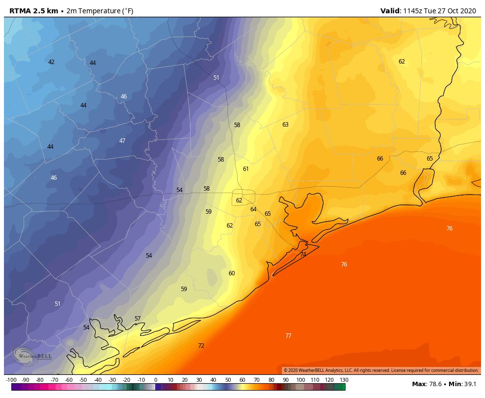
Houston’s weather this morning is something akin to the opening of Charles Dickens’ A Tale of Two Cities: It was the best of times, it was the worst of times. It was the coolest of times, it was the warmest of times. By this I mean that a cool front has sagged into the Houston region, and pretty much stalled right on top of our heads. To the west, it is cool and dry, to the east, much warmer and humid. Conditions will remain this way until the front bulls all the way through on Wednesday.
Tuesday
Temperatures are generally in the 50s this morning on the west side of town, in places such as Sugar Land and Katy. They are in the mid-60s in the central part of the city, and mid-70s along the coast and to the east. The line demarcating cooler and warmer air should waffle back and forth some today, and it’s impossible to predict precisely where with the front stalling overhead. So highs will vary from the 60s to 80s across Houston. Pretty remarkable. Skies should be mostly cloudy, with a few light showers possible.
Wednesday
A reinforcing push of colder air arrives on Wednesday, probably during the middle of the day, and this will bring fall-like weather to the entire area. We should see some better rain chances during the day on Thursday as the front slogs through, primarily from shortly before sunrise into the late afternoon hours. I think most areas will see 0.25 to 1.5 inches of rain, and I don’t have high confidence in pinning down where. Temperatures will drop to around 50 degrees Wednesday night in the wake of the front—cooler inland, and warmer along the coast.
Thursday
This should be a breezy day due to a strong pressure gradient in the wake of the front, with gusts possibly as high as 30 mph. Please take note of this if you have outdoor activities planned. Skies will otherwise be clearing out, and highs likely will only get into the upper 60s in most locations as colder air moves in. Winds should back off some toward evening.
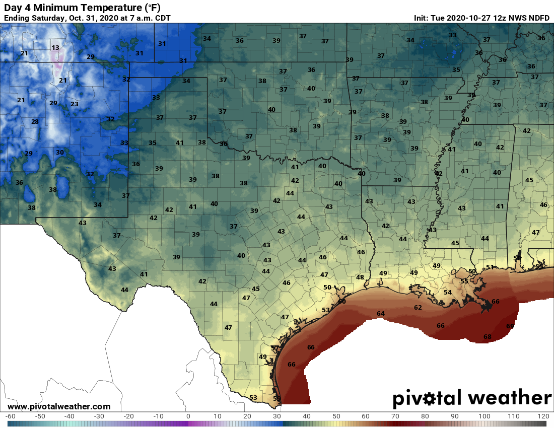
Friday, Saturday, and Sunday
This weekend’s weather looks splendid, with sunny skies, highs in the upper 60s to low 70s, and overnight lows in the 50s. For those wondering about Halloween rainfall, there will be none this year. Enjoy!
Next week
The models are suggesting another front may arrive by around Monday to keep the cooler, drier pattern going. However, overall confidence in this is not yet high.
Tropics
Tropical Storm Zeta crossed the Yucatan Peninsula during the overnight hours and is now emerging into the Gulf of Mexico as a strong tropical storm, with 70 mph winds. Confidence in a track toward the northern Gulf Coast is high, with the storm likely making landfall in southeastern Louisiana on Wednesday afternoon or evening. It should be a Category 1 hurricane at this time and its center may pass near, or directly over New Orleans.
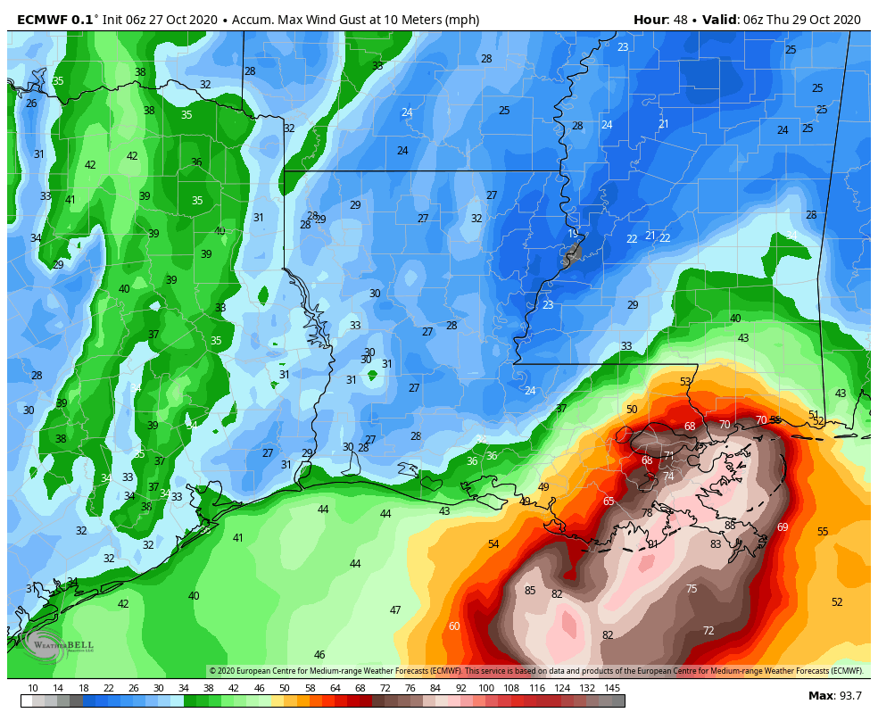
The storm will be moving quite rapidly to the northeast at this time, so while it won’t linger on Wednesday night, it could produce briefly very heavy rainfall and wind gusts above 90 mph over southeastern Louisiana. This is a nasty, late-season storm no one wants.
Is it possible for you to give wind forecasts? That’s the most important feature for fishermen.
Hurricanes.gov should have wind info 🙂
Windfinder.com
As always, thanks to Eric and Matt for ALL the work they put into the daily forecasts.
For a free hype-free website, their commitment is nothing short of amazing and we should be thankful for what we get as a result. Don’t forget that their annual fundraiser will be in November (if past trend holds).
I’m also thankful for the “splendid” forecast for this weekend!
In a sea of sensationalism and craziness, you are a peaceful haven of information. Can’t wait to see the app! Thank you for keeping us informed!
This is not really that pleasant of weather. Could be worse of course, I can’t believe that New Orleans might get hit by a hurricane in late October. The last thing that Louisiana needs is another hurricane or tropical storm.
Has there ever been a season where Louisiana was hit with so many hurricanes?