And so it begins. Tuesday marks the first of three days during which the Houston area will face the threat of heavy rainfall as moisture levels surge due to a tropical system moving toward us. As the system has become a little better organized overnight, it’s forecast track has also shifted subtly such that its very loosely defined “center” should now pass just to the west of Houston this week as it slowly lifts north. Here is a rough approximation of a 5-day track from the GFS model ensembles.
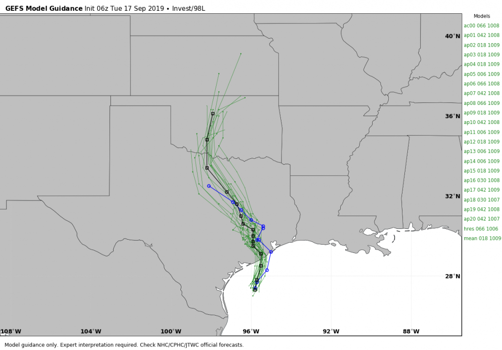
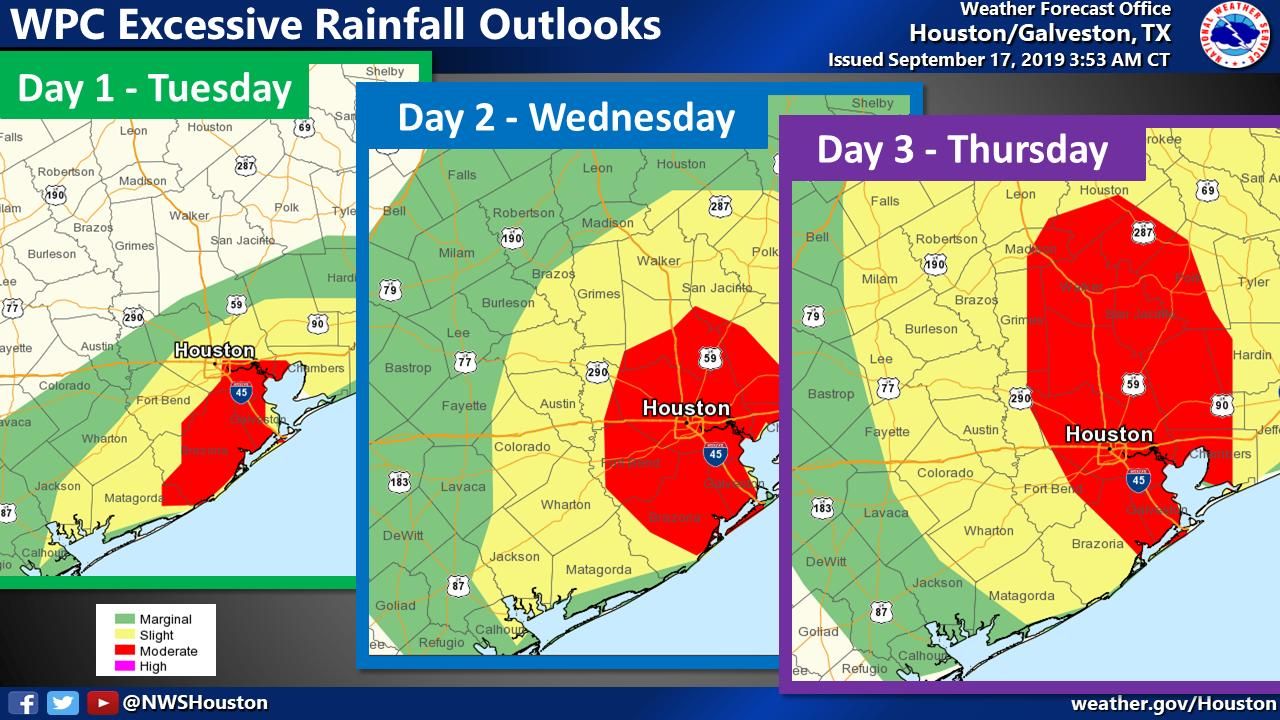
This path likely sets up the heaviest rainfall between Matagorda Bay and the Beaumont area, with Houston very much in the midst of the bullseye. Over the next three days most or all of Houston falls under the moderate chance of “excessive rainfall” according to maps published by the Weather Prediction Center—a strong indicator of where the best experts think the heaviest rain is likely to occur.
So what does this mean for Houston? It means that Tuesday will be somewhat wet, and Wednesday and Thursday have the potential to be very wet. In terms of travel and normal business, I do not think rainfall on Tuesday will be too disruptive, especially for central and northern parts of the Metro area. But there are strong signals in the models that Wednesday afternoon, night, and Thursday could be more problematic.
Where? The models have drifted a little bit eastward with this heaviest rainfall during the overnight hours—if this trend continues the heaviest rains could come down just east of Houston. But it is far too hard to parse such details at this point, and frankly there is a lot of moisture coming into Texas so everyone is going to get rain. I think widespread totals of 5 to 10 inches are likely for most people over the next three days. Some areas probably will see 10 to 15 inches of rain. This is manageable for most if it is spread over two to three days. But 15 inches in five hours would not be. Unfortunately, as we know, tropical rain often comes in clumps. The system has a shot at becoming a tropical depression or storm before landfall tonight—30 percent per the National Hurricane Center—but that doesn’t really matter. It is going to be a rainmaker regardless.
For now we are holding this flood event at “Stage 2,” because there is still the potential for the heaviest rainfall to remain offshore, or come in east of Houston, but we remain very close to escalating it to Stage 3 (as in, we think there probably is about a 50 percent chance of a Stage 2 event, and 40 percent chance of a Stage 3 event, and a 10 percent chance of Stage 4). There is just a lot of potential rainfall here to be tapped, and we’re quite concerned about what could happen Wednesday night and Thursday over the region.

If there’s any good news, it’s that this event seems likely to come to an end by Friday morning or so, by which time we can begin to dry out. Chances are also decent that we may finally see the season’s first front by the end of the month, although we’re not close to being able to be definitive about that.

Quick note: folks, let’s retire the Katy jokes for the duration of this event, please. After discussing w/Berger this AM, I’ll be removing any Katy comments to keep the discussion on-topic.
Amen to that.
On another good note, this looks like it will bust any drought that was trying to take hold and the burn bans will be lifted. But, my concern is that it started raining last night in Brazoria County and is continuing. But, it, so far, appears to be a nice steady soaking rainfall.
Let’s remove them permanently is what I say. Whatever funniness it had is now long, long gone
Thank you so much! Your willingness to keep the comments mature and sensible is VERY much appreciated by this Katy girl 😊
Flying into Hobby airport about 8am on Wednesday. Do you think it should be a problem?
Count on it being a mess the next couple of days.
Flying in to Hobby at 1PM local time. With a wife who is already an anxious flyer. Hoping for some good luck today!
Appreciate the information!
Thank you. These situations are where you guys become the absolute go-to source….and have been for many years.
Looks like a storm to me, they need to hurry up and name it. No ones going to remember the great tropical wave of 2019.
Actually, it would be best not to. A named storm could make a big difference on some folks insurance policies.
A named storm matters for insurance policies? Could you explain more?
Clear Lake has already been pretty drenched this morning. And I think the sun forgot to come up.
We’ve had fairly consistent rain in the Heights so far, but it seems to have let up. Hoping for the rainfall to be evenly spread out so it causes minimal damage for my fellow Houstonians at risk of flooding. Stay safe, everyone! Thanks for your level-headed reporting, y’all! You’ve been my go-to for roughly a decade When I want a solid explanation instead of a solid sensationalization.
Normal 30 minute commute was just over an hour.
Heavy rain around Ellington.
Lights at Hwy 3 and Edgebrook out.
Rail crossing at College going nuts, making lights mid-cycle.
Accident at Allendale.
Heavy rain along 225.
I assume this is just the start of the fun!
Outside of this being a significant rain event, do you foresee any of this weather being severe (wind, hail, etc.)?
Pecan Grove to Chocolate Bayou. Meh. Just wet. No hard rain yet.
I know this is hard to pinpoint, but I’m flying out of IAH Wednesday around 8pm. If it’s just rain I believe that we have a good chance of taking off, but does this system look like it will produce more severe weather?
As someone who flooded both tax day and Harvey this all makes me anxious. This go round I’m out of town, scheduled to fly home to IAH Wednesday afternoon. Guessing I should expect a possible flight delay and once in Houston a longer than usual drive home to Cypress. Praying that’s the worst it will be.
I love your weather reporting… no nonsense and trustworthy! Thanks!
A suggestion that for the Weather Flood Scale you change the i.e. in Stage 2 to e.g. so that people know that these cities are just examples rather than the only ones that can flood. (i.e. = specific, only ones; e.g. = examples). If I’m reading this wrong, apologies.
Does what you’re calling “east of Houston” mean Beaumont or east like Crosby/Baytown/Deer Park/La Porte?
Where does Eric mention climate change in his Report?
If only you could send some of that rain out towards us in the Central Texas.
Thank you!
Looks like the NHC is predicting a Tropical Storm (either Ismelda or Jerry depending on the race with TD 11) west of Alvin by tonight moving almost due north. Tropical Storm warnings up from Sargent to Port Bolivar.
Oh boy. We have T.S. Imelda