And so it begins … Texas suffered its first major blows from Hurricane Harvey on Friday, as the storm neared the coast and, instead of slowing down, kept moving right along and plowed into the Central Texas coast. It came inland shortly before 10 pm CT as an intense Category 4 hurricane. The early meteorology reports out of Corpus Christi and Rockport are pretty grim. Harvey should now gradually weaken, so long as it remains inland.
What happens now
I understand that some of you appreciate dark humor during these dark times, so I present you with this evening’s spaghetti plot of track models that were initialized at 6pm CT, and came out shortly thereafter. They are nonsensical. I posted them to Twitter with this comment: “Great to see that the latest forecast models are finally getting a good handle on Harvey’s inland track.”
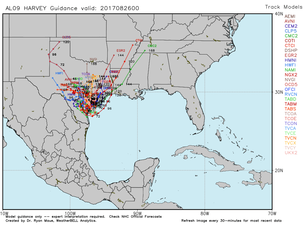
You have to laugh at times like these, because for a lot of us, the uncertainty, the stress, it can kind of become unbearable. In any case, be glad you’re not a meteorologist trying to make sense of a mess like that. But I am, and so I shall. The first thing to do is simply to ignore that plot.
Secondly, when you look at the major global models, and their ensembles, it seems pretty clear that they think Harvey is going to loop around South Texas, somewhere between Corpus Christi, Victoria, Laredo and South Padre Island, for the next 24 to 48 hours (and dropping prodigious amounts of rain there). After that, the picture becomes more cloudy. When faced with such uncertainty, if you’ve been reading me for any amount of time, you’ll know the way I like to address that is through probability. Let’s revisit last night’s scenarios, shall we?

The Euro special
- Thursday night’s probability: 40 percent.
- Tonight’s probability: 25 percent
This was the idea that the storm would stall inland, and then pull back over the Gulf of Mexico and eventually move north, into Houston for a second landfall, or into southwestern Louisiana. Under such a scenario, depending upon the track, much of the Houston area would likely get 10 to 25 inches of rainfall, with the greater totals closer to the coast. We would also have wind and storm surge concerns. I’ve backed off this idea a bit because no other model shows the scenario, and the European model isn’t entirely on board, either.
The wandering 59 special
- Thursday night’s probability: 35 percent
- Tonight’s probability: 45 percent
Under this idea Harvey or its remnants hangs around south Texas for a while, maybe several days, before eventually pulling north or northeast toward Houston. This emerged as the odds-on favorite today, and I discussed it in a somber post this afternoon. Really, this is a terrible option for south Texas and southeast Texas (which includes Houston), because Harvey remains close enough to the coast to regenerate its moisture content, and it dumps 20-25 inches of rain across a wide swath of Texas, including the Houston area (with higher totals). Widespread flooding ensues all over, from Corpus through Houston, and probably extending most of the way to Austin and San Antonio. Just brutal.
Dying in the Rio special
- Thursday night’s probability: 25 percent
- Tonight’s probability: 30 percent
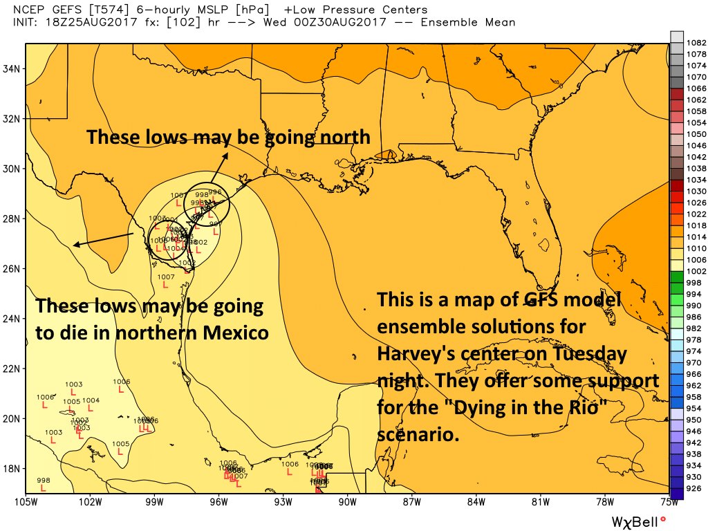
This was the scenario that had Harvey (and its remnants) looping around South Texas, but eventually it moved into central Texas or the Rio Grande Valley, whereupon it strays far enough from the coast to run out of moisture. In this case the heaviest rains are over the central Texas coast (God knows they don’t need the rain, on top of the surge and winds), and the area between Corpus Christi and San Antonio. However, this is a scenario in which the upper Texas coast, including Houston, may be “spared” by getting only 10 to 15 inches of rainfall over a few days as it lies on the eastern periphery of the heaviest rains. Some of this evening’s GFS model ensembles support this scenario, and I’m seeing some support from a few other models.
Key takeaways
- Hurricane Harvey is coming ashore tonight, and is the most powerful hurricane to strike Texas since Carla, in 1961. Spare a few thoughts for residents of the mid-Texas coast, who are being absolutely hammered by a major hurricane tonight.
- Houston has seen some tornadoes, and heavy rainfall, but so far the winds and storms have been manageable. CenterPoint reports, as of 9:30pm, that 99.3 percent of customers have power.
- We expect heavy rain to fall in Houston on Saturday, but accumulations will probably only be 1 to 4 inches (with higher amounts likely near the coast). This should be manageable by area bayous, aside from some short-lived street flooding in the most intense storms. We think most travel should be OK.
- A major flooding event will begin to ensue across Texas, starting near the landfall of Harvey. We expect the central Texas coast, including areas like Corpus Christi, Rockport, Victoria, and elsewhere to begin seeing serious flooding issues on Saturday.
- Heavy rains and flooding will spread into other parts of the state on Sunday, but exactly where is dependent upon the evolution and movement of Harvey’s core. We do expect heavy rains in Houston on Sunday, which may begin to impair travel around the area, but we do not have high confidence in this forecast.
Our next post will come on Saturday morning, by or before 7am. It’s Matt’s turn, so if the post is late, please flog him appropriately.
Posted at 9:55pm CT on Friday by Eric
Thank you for the bedtime story. Still thinking positive pop tart thoughts.
Sorry for the pun but thank you Eric and Matt for being the calm before the storm. You help us ward off data overload by offering us clear and concise updates. I appreciate the probability models, makes me believe you know what you’re talking about, just a little bit. 😊
Thank you Matt and Eric for all of your hard work, necessary humour, and no nonsense reporting.
^^agree 100%
I love this website. In an Era of news for reactions and instigating emotional terror. This crew is a light in the darkness.
Indeed! Faith in a single news source restored!
Thank you for the humor and the bottom line up front.
Great job as always, guys.
One thing I noticed, looking at some of the recent model runs (except for the Euro, which hasn’t been re-initialized since 12Z) is that more and more are heading Harvey deeper and deeper into even West Texas… where it will hopefully croak.
I wonder if this is maybe due to all the angular momentum the storm gained when it went Cat 4 or are we starting to see some definition (though different with different models) in the steering currents?
Lacking an imminent flood around Ellington, I’m headed to bed. Did not sleep well last night (I wonder why…).
These posts have been SO helpful, thank you.
Prepare the flog!
“After that, the picture becomes more cloudy.”
“It’s Matt’s turn, so if the post is late, please flog him appropriately.”
I shouldn’t laugh reading a post about a Cat 4 Hurricane, but these lines in particular made me giggle. Don’t get too punchy over the next few days, Eric and Matt. 🙂
No promises. We have a long way to go.
Appreciate your frank and clear reports
I also like the caption “Model Guidance Only”. Guidance? What guidance??
Thank you for the work you guys do. Hoping for the best.
Thank you for your work. You make a big difference.
Thanks guys, I’d be on maximum freakout if it weren’t for your calm, reasonable updates.
Not only do I trust you guys and read all of your posts, I publicly shame those who don’t. I so appreciate all your efforts and generosity. Hope you all can get at least a little bit of solid sleep tonight.
I think based on current models Houston will miss the biggest part of the rain. The heaviest rain will stay more west.
I love your no nonsense ( with humor) reporting. I live in LA, but have family in Texas. It is helpful to read clear, concise posts.
Thank you.
Well, roll a die, here’s hoping for the Rio Grande Experience!
Thank you guys, this is now my new favorite weather blog.
Aren’t we all in Houston.
Spaghetti. Funny. Levity helps and I appreciate the no-nonsense knowledge at the same time.
Thanks again ! For keep us sane, if not safe! 🙂
Thank you.
Thanks to you and Matt for your hard work. We so appreciate your thorough research and analysis and your honesty about the uncertainty of any forecast. You help us make informed decisions.
Also – get some rest!
The gospel. Thanks again for your work. You are more appreciated than you could know.
Feeling hopeful in Katy, but absolutely sick for those in Rockport and surrounding areas. Thank you Eric and Matt for helping us stay sane.
Thank you so much for this site. It is really scary trying to figure out the actual risks when you’re new to Houston.
It’s not that much easier when you’re not new.
” please flog Matt appropriately.” ha ha!!!
Matt, Eric, you guys are amazing. Keeping us informed but not panicking. Is there a pulitzer prize for meteorologists? Y’all deserve it.
I have three kids and their families in Houston. I just moved from Tomball Magnolia area and still own my home there. Sigh…Montgomery county doesn’t believe in flood control. Last year our neighborhood saw two homes flooded. I’m concerned it will hit our house this time.
Thank you for the real deal: info with no hype and Chicken little hysteria. Unfortunately, it does seem the sky is falling.
The sky is going to fall. It’s just a matter of how much. Pretty crazy that we’re “hoping” for just 10 to 15 inches of rain at this point, but here we are.
Indeed chicken little indeed 😂
Go south, go south!!! Please defy odds and do that, ok, Harvey?
Truly thinking of all Texans tonight.
Stay smart. Stay safe.
This is the best weather reporting I’ve ever seen. I will be watching this site closely, thank you for your work
That is high praise, thank you Collin.
You both are doing an amazing job. Your hard work is most appreciated.
Thanks for all your long hours and hard work. It makes a real difference to have you for no-nonsense information.
Thank you Eric, you bring moments of sanity in this crazy, stressful time.
Yeah, looks like Harvey arrived in Rockport a bit ahead of schedule. Wonder how close he will get to SA before he starts his dithering?
Looking at the latest radar animations (11pm central) it looks as if the eye is literally half-on/half-off shore. And it does NOT look like it’s going anywhere any time soon!
I really appreciate all your hard work, and your no-nonsense style. Thank you!
I want you to know how much this information means to those of us anxiously waiting at home. No other source of information even comes close. It gives me peace of mind just having some sense of what the possibilities are and how experts are understanding the data, and knowing that the information is coming in frequently, in real time. Thank you both!
I am sooooo happy I found you guys. My son keeps coming in with the hyped up reports telling me how they are saying we should evacuate but he doesn’t want to. We’re in Clear Lake. I keep making read your reports. I won’t read or look anywhere else. Thank you, I appreciate your hard work and approach.
Poptartless in Clear Lake. 😉
Eric, Matt, & Braniff your knowledge & wit have instilled calm in this Nassau Bay family. We’ve experienced our share of nail-biting, hair-pulling tropical weather in our decades here. Appreciate each of you and your dedication!!!
So thankful for you all!! This is the weirdest storm I’ve ever seen! My family moved here in 1980.
Thanks for keeping us up to date!
Tonight is the first time that I’ve ever seen your forecasts. You got me! You are my new source for weather forecasts and reporting. Thanks.
Thank you for the matter of fact, undramatized forecasting. This and NOAA are the only sites I look at.
It’s after midnight. Harvey has come ashore.
I have been thinking how beautiful a model Harvey is.
Warm waters. Low speed. Straight line. Build to Cat. 4. Hit land . . .
Then it goes into Saturday with no predictable guidance at all.
Take care.
I want to throw my hat in the ring and express my gratitude for the amazing job you guys have been doing. I have been relying on your steady hands to guide us through this difficult time with your clear reporting. Thank you again and God’s blessings to all those bearing the brunt of the worst.
sugar land here (highlands)… just lost power shortly after 1 am. Had hoped it would hold out a little longer.
bummer. whoa… clicked back on as I was typing. we’ll see how long this lasts
Found this blog earlier in the week by chance. Been checking in daily ever since. Intelligently presented info without sensationalism and “doppler” bragging. And I love the humor, too! You are truly performing a community service. Thanks from Sugar Land!
My wife said this was the best place to go to for weather reports. Dammit I hate when she’s right. Damn you for being good at your jobs. DAMN YOU!
So glad I found this website. Thank you so much for what you both are doing! Everytime I see a inflammatory comment or article online I come check what ya’ll say instead. Love the honesty (even when the answer is we don’t know) and the humor!
My first hurricane! And thankful for your posts. As soon as I start to panic from watching the news I visit this site for a reality check. Your information is helpful, informative and calming!
Happy to have found this website today…not happy about the storm. I love the straightforward information as I have family and property in the Houston area and I’m in Canada right now. Keeping a watch on your site and let’s all collectively cross our fingers. Stay safe, everyone.
Can we make it to San Antonio? We have access to a house on a hill there. Should we try to go?
Looks like Matt earned a flagging. Lol. 7:10 and no update.
Thank you for all of your straight forward reports – and making us laugh in the face of all this. You’re appreciated!
Its after 7am and I’ve got my flogger ready bc there’s no update yet. Ha ha. I really appreciate this site and have shared it with all those I know both local and out of state (bc they have no clue what’s going on based on the regular news reports). Tremendously calmed down my panicky friends and my adult daughter (big baby). Thank you guys. You are book marked!