As of 7:45 PM Friday, Hurricane Harvey has been officially upgraded by the National Hurricane Center to a category four storm with 130 mph maximum sustained winds. Port Aransas just gusted to 105 mph as the eyewall approaches. Should Harvey make landfall at its current intensity, it will be the strongest storm (by wind) to hit Texas since 1961’s Hurricane Carla (which came ashore just north of where Harvey should) and the strongest in the U.S. (by wind) since Charley hit Southwest Florida in 2004.
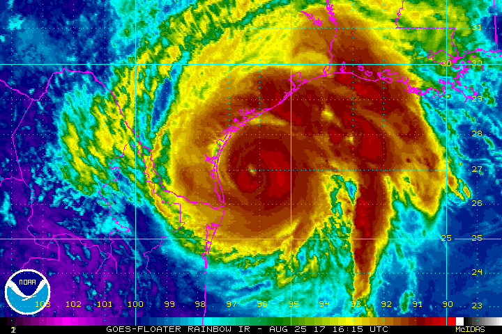
Coastal Texas from near Corpus Christi north to Matagorda are being absolutely pummeled by wind and squalls and they will continue to deal with this in the hours ahead. Few words needed to describe the situation there, and our thoughts are with folks that live in that region.
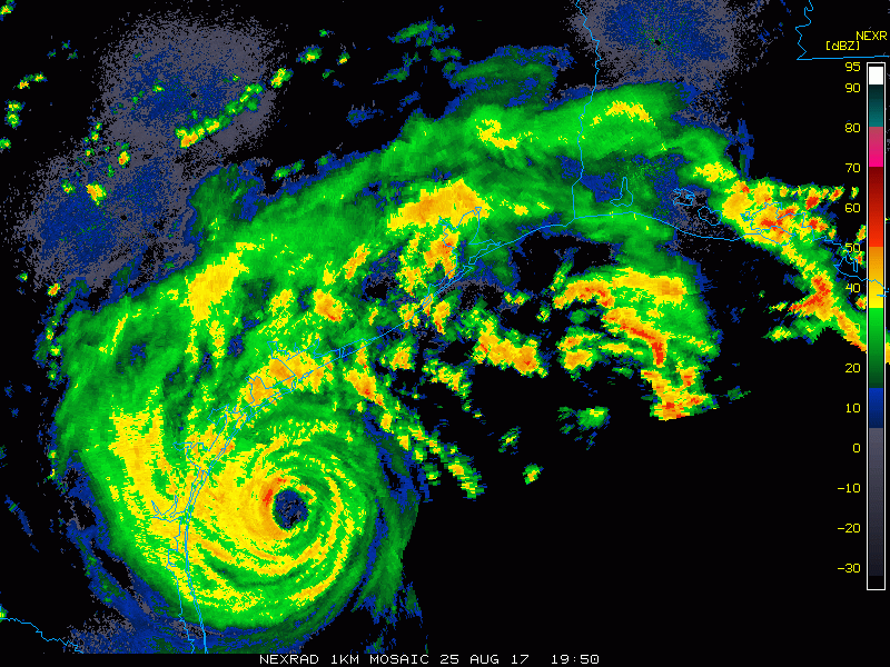
Here in the Houston area, things are also active. We’ve had numerous tornado warnings issued throughout the day today, mainly south of US-59 and I-10. As these squalls and feeder bands on the north side of Harvey come ashore, they are capable of producing brief tornadoes, mainly in the coastal counties. These are extremely difficult to warn on because they spin up so quickly, and the NWS Houston office has done an outstanding job thus far with them. If you are placed under a tornado warning tonight, do take it seriously and seek shelter at your location (lowest level of the building in an interior room). Have a way to receive warnings overnight. A tornado watch remains posted until at least 2 AM for the Houston area, along and south of US-59 to I-10.

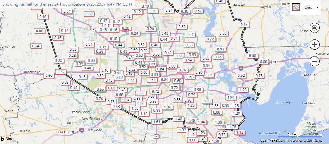
Rainfall thus far today has been tolerable in and around Houston. Most areas north of I-10 have seen around or under a half inch. Areas south of I-10 have seen more, with 2-4″ falling near the coast south of Harris County.
The next 12 hours
So what is in store for us tonight?
Rain: As Harvey moves inland, the somewhat sporadic rain and thunderstorms will become more frequent. After midnight, I think it will be raining the majority of the time in and around Houston. Rain totals will vary depending on exactly where the most frequent feeder bands setup before everyone sees heavy rain overnight into Saturday morning. I suspect we could see an average of 1 to 3 inches of rainfall by 7 AM Saturday, less north, more south. There will likely be some areas that pick up somewhere in the ballpark of 3 to 5 inches. The best odds of that occurring will be south of the city, closer to Harvey’s core (Brazoria/Matagorda Counties).
Flash flooding is likely in spots, though widespread river and bayou flooding should hold off through tomorrow morning (this will become more of an issue, and a serious one, after more and more rain falls).
Tornadoes: As outlined above, isolated tornadoes are likely tonight, mainly south of I-10, and short-fused warnings should be taken seriously.
Wind: We also expect winds to increase a bit (probably not a ton) as the night goes on. So far, Hobby has only gusted to 37 mph. As some of these stronger and more frequent rain bands come ashore, we could see a few 40 or 50 mph gusts, mainly south of the city. Stronger winds will be possible along the coast in Brazoria and Matagorda Counties obviously.
Surge: Tides are likely to stay high into tomorrow and much of the weekend with persistent onshore flow preventing a lot of drainage in the bays. That said, most coastal flooding impacts should be minor in Galveston for the next 12 hours. Once you get to about Freeport and southward, that is obviously where things get very dangerous.
What’s Next?
So what’s to come. Sadly, this storm is a marathon, not a sprint. We have a very, very long way to go. Here are some forecast thoughts looking ahead to tomorrow, Sunday, and beyond.
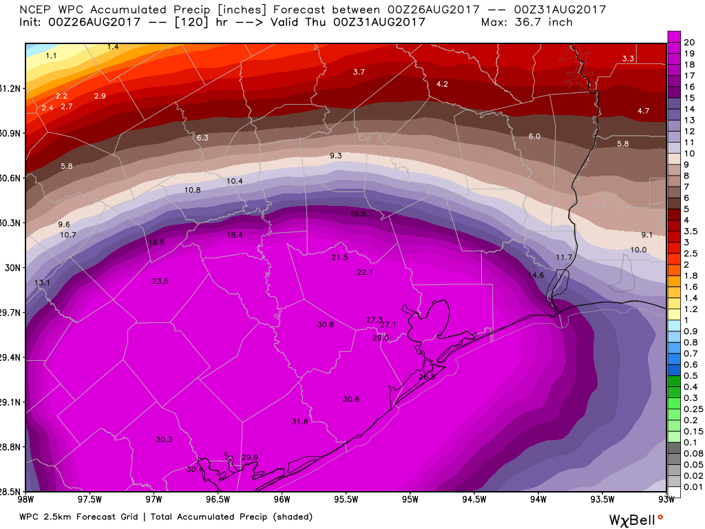
- Total rainfall forecasts are almost unfathomable, but this is a unique situation. The largest rain totals will be southwest of Houston over the next several days. I personally believe the Victoria area down to Port Lavaca is really going to get inundated with heavy rainfall. This is where the official NHC/WPC rainfall forecast shows a bullseye well over 30 inches.
- As each wave of rain in the Houston area drains into the bayou system, flash flooding and possible bayou and creek flooding will become more and more of an issue. Braniff Davis published a good post on inland flooding earlier today and described how rain rates matter. It’s impossible for us to peg down exactly where the worst rain rates will be at any given time, but with 10-20″+ of rain falling over the next 4-5 days, we know they will happen in spots and at times.
- Weather model data today has indicated that Harvey will stick around (though not in its current form) perhaps for the better part of a week, delivering periods of rain to the Houston area. It won’t rain the whole time, and we may even see sunshine from time to time throughout this event. But you’ll need to be prepared to deal with travel disruption, inconvenience, changing forecasts, and perhaps cabin fever in some cases. As said above, a marathon, not a sprint, and unfortunately we all have to participate.
- Will there be a Harvey reborn Act II? Doubtful. Weather models have pulled back on the awful scenario depicted a couple times in recent days with Harvey hanging offshore as a hurricane or strong tropical storm. That would just compound an already terrible situation. We’ll continue to watch, but that’s not at the top of the list of concerns at the moment. Flooding and heavy rainfall tops the list.
- That said, Harvey will maintain tropical storm status for a long time over land it would seem. No, there won’t be constant 40 mph winds buffeting the Houston area. But as some of the heavier rain bands and squalls push through over the next several days, don’t be surprised to see 35-45 mph wind gusts and sporadic power outages.
- Stay calm, stay put if you can as long as it’s safe. Continue to monitor the storm and the forecast via SCW, media, local government, and the National Weather Service.
On a final note, I want to really commend the National Weather Service forecast office in Greater Houston for the job they’re doing. Trying to deal with flooding rains, hurricane impacts south, and these quick spin-up tornadoes is so difficult. They’re working their rear ends off for all of us, and that’s truly commendable. Eric and I will continue to keep you informed through the storm.
Posted at 7:45 PM Friday by Matt
Thank you for your balanced, informed, and thorough reports!
NWS aside, YOU guys at SCW are doing a tremendous service to us all. Thank your and thank your families for sharing you with us during the days ahead.
Yes!
Can you elaborate on why you are doubtful of Harvey going for a round two that then heads closer to Houston? The more recent track published this afternoon seemed to show that?
Thanks, Matt. I hope Eric is getting some rest.
Thanks – I just recently found your site and am so grateful to have great reporting with the hype. Awesome job!
Can you elaborate on why you are doubtful that Harvey will go for Round Two and come back in closer to Houston? The track published this afternoon seemed to show that?
+1. You guys rock.
I don’t know why but I find this report oddly comforting. Serious but as specific as the known facts allow. So much better than the stuff online where there are warnings to write your SSN on your arm in permanent marker. Egads.
Thank you guys for all of the posts over the last few days. This is our first hurricane, this at least gives me a little relief that we aren’t committing guaranteed suicide by not evacuating houston.
In your opinion, would it be foolish to leave for Arkansas from west Houston tomorrow morning, say around 9am?
Eric and Matt–I know you are in for the long haul. Thank you for the consistently good information. Prayers for you guys and your families too.
Thank you for these updates. As someone who only moved to Houston a few years ago, having your analysis to read has been extremely helpful in understanding what’s happening and what is likely to happen.
Your reports are the best. Thank you so much for your work and knowledge and helping us understand the situation.
Cannot underestimate how much your blog followers appreciate all the work you and Eric have -and continue to- put into keeping us calm yet highly informed. Thank you!!
Thank you, Matt.
Thanks for being a voice of reason. The Weather Channel and other national media outlets seem to be scaring people to death to get people to watch. It makes me want to turn them off, which I have. We know how serious this is. Calm and not panic is what we need. Thanks again.
Great stuff gentlemen! Keep up the great work!
You guys ROCK, thank you!
I have family and friends in the Austin area and points north along I-35 (Georgetown, Salado). Any concerns for them?
Not too bad in Cypress so far. .26″ of rain and gusts up to 9.8. Here’s to the start.
These are fantastically written, straight forward updates about the situation at hand and what to expect in the coming days. Thank you!
Eric,
Thank you for an outstanding job of condensing the data in a readable and complete form. This is why people look for your reports before they go to some other source.
Thank you and please stay safe.
Thank you!
When will the rain clear up over Houston? Thursday? Friday? No telling? Thanks for all you are doing, it is so appreciated.
Thank you so much for all ththe work you do for us! Is this here any way to see the above map with areas labeled or roads even just the main ones?
If you look at the county lines, you can see the whole Houston metro area (except for northern Montgomery and Liberty Counties – basically Conroe and north) is due for 20+ inches of rain. The whole of Harris, Waller, Chambers and Galveston counties are in the purplest possible zone on the map. Fort Bend and Brazoria, as well, but the numbers indicate they’re looking at >30″!
The 30.8 figure is almost directly on top of the Sugarland-Stafford area. The 30.6 is close to Lake Jackson. The 22.1 is probably IAH with the 21.5 the Spring area. 29.0 is Pearland.
What are your thoughts about the tornado watch being extended in the Houston area?
Matt and Eric, what do you think is the over/under on the number of comments before someone asks if they should bug out of Katy or if their flight in on Sunday is likely to be delayed? *snerk* T
Seriously though, thanks for your hard work. This website is a godsend.
Thanks for keeping the greater Houston area informed and aware. Been linking to your site quite a bit over the past couple of days.
Such a realistic and sober assessment and such a contrast to the panic mongering of so much of the television coverage!
Harvey is stronger than Ike? I thought Ike was a 5. How does Harvey compare with Ike?
I think by landfall it was a cat 2
Thanks for the update. Y’all are doing fantastic work; we’re all extremely appreciative!
thanks, i apreciate your efforts on this.
Thank you! I so appreciate your reporting.
What’s currently terrifying me is the flood prediction.
http://water.weather.gov/ahps2/hydrograph.php?wfo=HGX&gage=BACT2
Numbers not seen since the late 1930s. There wasn’t much down in that area 80 years ago.
When will clear out? This weather is disappointing and depressing.
Adding my thanks for all that you both havery done & are doing. I have been checking this site compulsively all week, and I’m sure I will be for the next week as well.
Such an excellent job covering this event, y’all. This is my go-to source for all weather information (even outside of Harvey). Please keep up the consistent updates. They are much appreciated. Particularly, I’ve been enjoying your analysis of the projected path of the eye and what models are saying about stalling, moving up 59, kicking back out into the coast, etc. A lot of folks I’ve seen commenting seem to be interested in high level information (or forecasts for their neighborhood lol), but just know a lot of folks greatly appreciate y’alls technical review of the available data! Thank you guys very much for the consistent updates. You’re helping people stay safe. Keep up the fantastic work y’all.
Nicely done. Thank you.
I cannot thank you and Eric enough for your reporting. I always feel better after reading your posts. Watching the news has been crazy! Thoughts and prayers going out to our neighbors down South.
Matt, just want you to know that I rely on your weather reports. I no longer listen to the broadcast stations due to all the hype and scare tactics. Even your bad news somehow calms me down. Thanks for all you and Eric are doing. Your work is much appreciated!
Thanks for your efforts, I’m glad I found your blog as I am out of state and can do nothing but hope for the best.
A serious question, I have been checking various weather stations off an on all day, including some offshore platforms very close to the eyewall. So far, the highest wind gusts I have found is 90 MPH at Aransas Wildlife Refuge just now. Bravos 451 just on the 12 mile limit SE of the old Colorado River mouth at Matagorda shows sustained 48 and gust 60. I assume the lower wind speed readings are because the much higher 130 readings exist only at the eyewall?
For everyone who thanks you here for great reporting, there are probably 100 more who read it and appreciate it. Thanks for keeping us informed and keep up the great work.
Thank you for the continuous, clear updates.
We’ve had fairly continuous rain since 2 pm in Meyerland/Westbury — is that all the outer bands or just low pressure kicking up in the atmosphere?
What a great website. Thanks for everything.
Thank you for the thorough summary. Please keep updating in the same fashion. Very, very appreciated!
So pleased to have found voices of reason and calm. You’re to be commended for acknowledging the hard work of others to keep us informed; unity in times of emergency is powerful. Your words are greatly appreciated!
“On a final note, I want to really commend the National Weather Service forecast office in Greater Houston for the job they’re doing.”
So pleased to have found voices of reason and calm. You’re to be commended for acknowledging the hard work of others to keep us informed; unity in times of emergency is powerful. Your words are greatly appreciated!
Thanks for the excellent coverage.
Matt & Eric thanks for this excellent Harvey report! Very informative Space City Weather.
Appreciate the great work. Thank you
Thank you from a Houston newbie. We are hurricane tested from living in North Carolina but this one is a complete outlier. Good to read the sober truth.
I’m down in Bolivar peninsula on the towboat. I’ve been seeing winds steadily increase throughout the day I’m up to 35 gusting to 50. And I’ve been seeing heavy rain all day. Surge is only about 1-2 feet right now.
That’s pretty good for the surge, to be honest.
I have been surprised myself. Normally the island has water over it but we are at low tide right now so that might be part of it.
I cannot thank you enough for this detailed and matter of fact information! Thanks for helping Houston weather the storm.
Prayers are going to all people that are in the path of this Strom. Also thank you for great information