This afternoon’s post will focus on now-Tropical Storm Harvey’s inland track. Where the center goes from here is going to make a big difference in terms of whether Houston sees widespread flooding—or not. Unfortunately, the track forecast has remained something of a mess.
But before that discussion, just a quick update on the state of rains in Houston. The heavy band we were concerned about this morning has slowly moved north-northeast of the central Houston area, and this has allowed the city and its bayous to dry out a bit. This is good, because we expect more rain bands to move into the area later today and especially tonight. For now travel is mostly safe, but try to stay off the roads unless you really need to go out, and complete any trips before dark. Also, if you’re wandering around outside, be careful of wildlife. It, too, is looking for shelter from rising waters.
Harvey’s track
The big question is where Harvey’s center (and its outer rain bands) will go over the next few days. While 10 to 15 inches over three or four days is a lot of rain, for most of Houston it is manageable. However, 20 inches or more will cause widespread problems.
What I think I know today is that there’s a chance the Houston region escapes catastrophic flooding. I feel better than I did yesterday at this time, when the forecast was almost completely grim. Let me explain why.
Both the GFS and European model runs have Harvey wobbling around south Texas, and the central-Texas coast today through Monday, and then they bring the center back out into the Gulf of Mexico near the point where it made landfall late Friday night. But neither model keeps it offshore for long, and at this time I don’t think significant re-intensification is a major threat. No, the long-term worry for Houston, the Texas coast, and much of southern and southeast Texas remains rainfall.
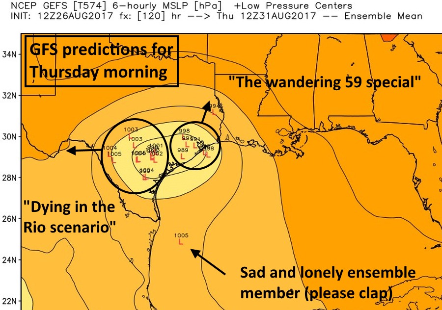
By Wednesday night and Thursday morning the GFS model ensemble solutions (shown above) start to diverge, with a slight majority dragging Harvey toward the Rio Grande and ultimately toward lower pressures over northern Mexico. This is a good scenario (Dying in the Rio) for Houston because it ultimately limits rainfall potential over the area. The remainder bring the storm north toward Houston (The Wandering 59 special). This results in more rainfall for Houston during the middle of next week, when we certainly will already be waterlogged.

Rainfall forecasts
The other hopeful trend is that the GFS model has backed off some of its extreme rainfall amounts for the greater Houston area. For example, in this afternoon’s GFS ensembles, there appears to be only about a 50 percent chance that most of Houston receives 10 inches, or more, of rainfall over the next five days. However, the European model is still pretty bullish, with widespread totals of 15 to 20 inches over the next five days. (One key test of this will come tonight—if we pick up 5 or more inches, we’ll know we’re on track to the higher end totals).
Finally, it is worth noting that both of the models are much more aggressive about rainfall totals down the coast, with various forecasts showing 25 to 40 inches of rainfall over Victoria, El Campo, Palacios, and other locations near and around Matagorda Bay over the next five days. Obviously these would create devastating floods for an area that has already coped with damaging winds and storm surge.
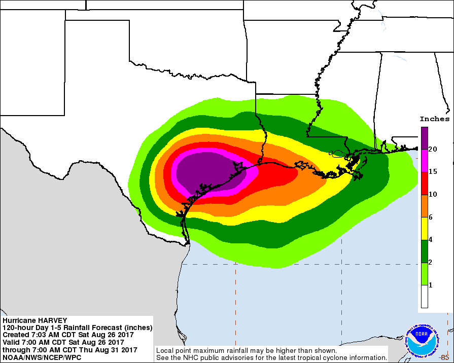
Bottom line with rainfall: There’s a ton of potential here with a low-level circulation (Harvey or its remnants) and proximity to the Gulf of Mexico. The greater Houston region has sustained 4 to 8 inches during the last 24 hours from Harvey, and come through pretty well. One or two more days with those totals in the wrong places, however, will be pretty bad.
Key takeaways
- Texas is absorbing major rainfall from Tropical Storm Harvey, and will continue to do so through at least the early part of next week. We will see major flooding in the vicinity of the storm. It is not certain where.
- Houston remains at high risk for significant flooding through the early to middle parts of next week, but I don’t think it is a guarantee that we will see extreme conditions
- For much of Houston there is something of a lull in storms on Saturday afternoon. This is a good time to shore up property, or make other preparations required for additional rains in the coming days.
- We have some concerns about heavier rainfall returning tonight across Harris County, and will discuss those in a posting later this evening if the threat becomes more clear.
We will update by, or before 7pm CT today. I will also have my nightly wrap-up around 10pm tonight.
Posted at 1:45pm CT Saturday by Eric
Eric, we are newbies to tropical storms and my wife – a Californian who is completely foreign to these types of storms – got freaked out to the point that we left for Austin on Friday.
Looking at updated models, it seems like we could be stranded here through most of next week while the area we live in (NW Houston outside the loop) isn’t seeing significant rain. My question for you is whether you think it would be safe to head back to Houston tomorrow?
Eric, this post kinda sounds like the projected rain forecast is a bust. I’m reading discussion on several consensus models that *do* show high rainfall amounts (maybe not in the 50+ range but over 20). I know the NCH track has changed a bit but models (aka Euro) are saying Eastward movement…..or if North clipping the Northwest section of Houston. Maybe folks are hearing “not so bad”and going “whoo! Bust!”???
Unfortunately, your situation is typical. Folks leave Houston for Austin only to have the storm follow them. Especially true if the storm actually comes in more around Corpus.
Son drove back Saturday morning from Austin with no hassle. Of course that doesn’t say what will be in store for Sunday. My best guess is early Sunday you’ll see rain, some heavy, but nothing terrible. Harvey isn’t projected to move north until Monday and be moving away from you on Sunday. But as a TS the bands will widen so its a tradeoff.
Maybe come back via 290 rather than I-10 to be a little further north. Probably a good route since you say you are in NW Houston.
Nothing burger.
That would a nothing Berger.
Sorry, couldn’t resist.
I wish you could give us some info about the Brazos River around Richmond. Last night we received 9 inches of rain. How will that affect the subdivisions around the Brazos River in Richmond?
We can’t cover every river basin and bayou right now. You can keep track of the Brazos at Richmond here, however.
https://water.weather.gov/ahps2/hydrograph.php?wfo=hgx&gage=rmot2
Voluntary evacuations have been issued for Brazos and San Bernard rivers. Check fbcoem.org for more info.
Ernie, Fort Bend Co has issued voluntary evacuations of the low lying areas around the Brazos River. They say homes and bussiness that were flood last year are likely to do so again this year based on their tracking of the river. The Fort Bend Co Emergency Response Page on Facebook is keeping up to date with the Brazos River rising.
Thanks for your analysis. We here in Montgomery County salute you.
Hopefully the Lake Conroe area will survive, but I am worried about swollen San Jacinto flooding the lake.
Those areas did take a lot of rain this morning. Long-term I think the bigger threat is probably south of you, however.
What do you think about the band of dry air getting swirled into the eye from north/central/south texas – seeing that on the water vapor map, and wondering if that will de-energize the storm.
It seems much of NW Houston has been spared between bands since early this morning. What are the odds this luck holds?
Yeah, NW Houston hasn’t seem much since about 8 am. Wondering when the next band will come back around and hit us.
👏👏
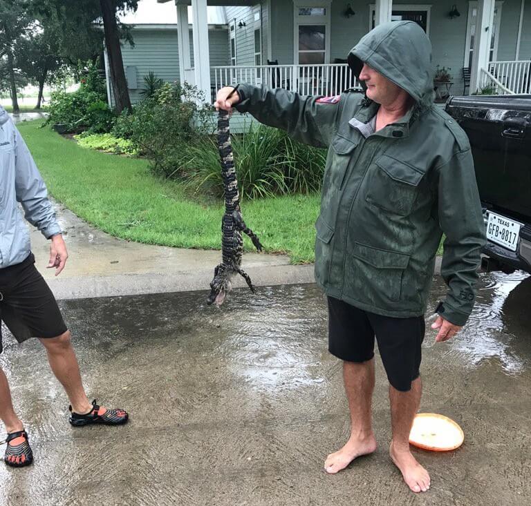
I’m in League City, next to Clear Creek! Time to find me a ‘gator!
(And get bit by a snek in the process)
Thanks for the good news, but we’ll stay vigilant.
Thank You, Eric.
Thanks so much! I read your forecasts first.
Keeping our fingers crossed that Harvey manages to die a quicker death than expected, but, regardless, gets off top of the greater Rockport area to allow some emergency personnel to begin to assess damage.
We are spreading the word about y’all’s great forecasts near and far. As soon as this craziness is over, you really should run a fund-raiser before everyone forgets how much they relied on your timely posts for this Event. (We know about the one planned for end of year, but really think you should run one soon.)
Thanks for sharing. The site has gotten a lot of attention, and we really appreciate it.
I completely agree, Shelly. I don’t listen or look at any other than the Space City Weather. Thank you, Eric and Matt.
I completely agree. We are here in rural Massachusetts and are relying on your posts more than any other sources for our neighborhood and for Houston. Thank you so much and keep up your exceptional work.
Mr. Eric,
I live off of I-10 and Antoine. We have not seen a lot of rain. We have not seen a lot of wind. I’m wondering if we’re just lucky?
We have predicted that winds would be manageable (and they have been).
If you haven’t seen too much rain, count yourself lucky. Also, some is coming.
So one of the major concerns you talked about yesterday was the inability of rainwater from creeks and bayous being unable to get to the bay and drain due to winds and surge. How are we looking on that front (especially in League City)?
I’m going to ask what we’re all thinking: What are the odds of power going out during the Game if Thrones season finale Sunday night?
100% chance of power going out where you live 2 seconds before the game winning field goal attempt.
@Es, haha! I’ve been worrying about that since yesterday! Harvey better not screw with my GoT episode. 😉
HBO has stated they are pushing the air date to the following Sunday.
So the “slight majority” drag it to Rio to die, that would be a plus for sure, we talking 55-45%, 60-40%? It is funny though how most if not stations and weather sites always rely on the model that is the worst case scenario. I assume they play a huge CYA game but it is a little frustrating when trying to understand what to prepare for. I am north of old town Katy, we have never flooded here since I have been here, Ike, memorial day, tax day (that dumped 16-18″ at the house in about 10+ hours) so I am hoping Harvey visits south central TX and Northern Mexico.
Thanks. Many thanks.
Like so many have posted before me….thank you for your calm and rational delivery of the available information about this storm and it’s impact on Houston. Your interpretation of the meteorological data and offering of potential outcomes has been invaluable to me in anticipating what might be ahead and how to best prepare. The thoughtful injections of humor and great writing style have been a delight in the midst of the storm. I used to read Eric as SciGuy in the Chronicle and have continued to follow since the inception of Space City Weather. Thanks again and best to all as we navigate our way through Harvey.
I am new to your website. Thank you so much for your calm and rational approach in your forecasts. I have always thought that most “weather personnel” were more interested in scaring people rather than just plainly giving objective forecasts. You are definitely the latter!
Minamally encouraging but I’ll take it. Your honesty in evaluating the situation is very appreciated; and unparalleled in the media. Thanks so much.
We are so grateful for your calm, steady reports as our granddaughters are living near the Brays Bayou at Stella Link. Thank you for your calm, clear headed reporting.
Hi! Thanks for all you guys do!! I’m out in fort bend (greatwood area). We saw significantly bad weather last night and numerous tornado warnings and possible touchdown(s). Should we expect the same tonight? I was only able to sleep about 2 hours and was on edge with the warning alerts and horrible noises and wind all night. Would like some relief. Thanks !
There’s the potential for that again, yes. Matt will have more on this later this evening.
Unfortunately we are under a tornado warning now in Katy thru 5pm 😩
Thank you!
Fervently hoping we will get to Blame It On Rio… thanks for these concise and fact-rich postings. Invaluable to keeping abreast of the fast-changing conditions.
When you cited about 5″ of rain overnight tonight as more supportive of the 59 Special outcome, what would you say is the lower value below which similar support would be lent to the Dying in the Rio scenario? Obviously not a sharp cutoff at 5″, so how wide’s the grey area?
Thanks Eric and Matt for the great reporting and interpretation.
When the immediate crisis has passed and he’s had some rest, I hope Eric will revisit the risks the Houston area faces from storm surge. In less than 10 years, we’ve now had two near misses. Either Ike or Harvey could have been the “worst case” scenario had they hit closer to Freeport. Think of the suffering and destruction we’re seeing now but visited on 50x more people, with an epic environmental and economic disaster piled on top.
I want to say I remember an article by Eric in the Chronicle (that predated Ike or even Katrina) about such a scenario, but I can’t seem to find it online. However, this article is recent and very good on the topic:
https://projects.propublica.org/houston/
Eric,
Your thoughts on the Sugar Land Brazos river area.
Thanks for everything.
Great Job
Monty
Thanks for the reliable reporting. Do you think that the Houston(or surrounding areas) are still prone to the catastrophic flooding(20additional inches), by wed morning?
Thanks. First time I read your blog was in 2005 for Rita. You are my only source for weather related news ever since. Really appreciate your analysis and no hype/BS approach.
Not that I’m disappointed, I’m grateful, but this is sure starting to smell like another busted forecast. The system is obviously losing energy and petering out. It also did not immediately bounce back into the gulf as once predicted (or hover half over the gulf), gather more energy, follow really any of the previous forecast tracks, etc. Please don’t be offended, I love what you do for the community (and your blog), but this will cause great skepticism the next time a major warning goes out. It really seems like the science isn’t there when it comes to making these predictions.
Understood, but remember that this was a Category 4 storm at landfall that was slow-moving, intensifying over extremely warm waters. That is not a “bust” forecast. If Houston ends up with less effect than Eric and Matt predicted, it may help to call it a miracle, not incompetent science.
I respectfully suggest that it is very premature to draw any such conclusions. The next 24 hours will be extremely telling– tomorrow is a big day for what happens with this storm. Let’s see what’s up then.
As always, thank you for your time and insight.
Your analysis is always so helpful – thank you. Trying to figure out whether it’s better to fly into IAH (if flights are happening) on Sunday or Monday, or later in the week. My car is parked on one of the nearby lots (hoping it’s ok), and I live in Westbury, near Meyerland. What to do, what to do? Weather here in Montreal could not be more perfect, but the work computer is at work, since I thought I would be here only a few days. Your thoughts on best day to fly? Sunday? Monday? Later?
Eric,
Please let us all know, how we can support the great work you are doing;
I truly mean it,
In Europe, so worried about my family and do grateful to You
I have to say that watching the news, is still doing doomsday reporting — I really want them to report that a lot of areas mine for instance (near NRG/inside the loop)–have seen less rain than many typical days in the summer. It is like areas like mine don’t even exist….My local gauge shows 2.12 in in the last 24 hours. Looks like inner loop has only got 2-3 inches at the most looking at the FWS, the bayous can certainly handle that. On a typical rainy day, I would be doing a lot of things out and about. Instead I have lost a lot of money by cancellations at work and several meetings cancelled. The panic mode the weather-casters put our city in –from yesterday morning until God knows when next week– has real negative effects on people’s lives and livelihoods. I certainly feel for those in Rockport in the path of the Hurricane and those who had tornado damage but inner Houston is high and dry so far for crying out loud…
Pearland is catching a nice break this afternoon with that gap between the rain bands. Not in the clear yet, but every hour it doesn’t rain has to help, right?
Also I’d much rather be prepared for the worst and it doesn’t end up getting that bad!
I lost it at (please clap).
Thanks Eric, honestly you have been a true hero for me and my family. We always wait for your expertise in these times of extreme weather. Keep up the GREAT work!!
This is where I find reliable local weather insights and a voice of reason. Thank you for taking a measured, non-frenetic approach to your forecasting and analyses. I turn to you first to understand the potential weather scenarios better and appreciate that you’re about straight talk and no hype.
Do y’all know anything about Brazoria county and the Brazos and San Bernard River? I know you can’t track every area but there are some very intense claims going on down here and would appreciate yalls level head. Thank you so much for all you do.
This is a great resource! I found you thanks to a re-tweet by someone I follow on Twitter. Thanks for giving us the details in a calm, rational manner. Cable news is freaking everyone out. I have told my family and friends to follow you, to hopefully bring their blood pressure down. 🙂
Hi Eric,
I’m in Sienna Plantation we were directly hit by a tornado and lots of rain thankfully our house was spared, but it was the scariest storm I have witnessed and I have been through all the storms since the 80s. My 8 year old was terrified. We have had a respite, but will we have the potential for that kind of weather in this area again tonight? Thanks so much
We’ve very clearly been told that significant amounts of rain aren’t expected until this evening and tomorrow. Sure some people aren’t in current bands of rain but that doesn’t mean anything for the future. Today has gone pretty much how I’ve expected it to after reading this blog. Weird to see so many comments, on this very site, thinking this thing is over. Maybe we get lucky but the potential impact on Houston is just beginning.
Eric-
Don’t know if this was mentioned in the comments, but please please photoshop your pic and blur out the license plate. As you know, there’s a lot of weirdos out there lol.
Thank you for your calm and no nonsense updates. My family and I have been reading your posts for years and recommend you to all our family and friends for weather reporting. Thanks again!
But does anybody know of places still open to show the Mayweather fight? 😉
I would like to know if tornadic threats are going to be great tonight. We always hear about flooding, but are the bands tonight going to be strong?
Thank Bill Wyatt for getting lots of people on here … great job guys! (Hw6 and Westheimer)(Grand-kids Braes Heights).
I approve of this message. Thanks, Eric.
Looking forward to your update at 7ish. Some of the local station are now starting to adjust the track keeping more west, heading up through LaGrange after it falls back to the coast a little. Some of the models I have looked at show the Del Rio retreat as a higher probability.