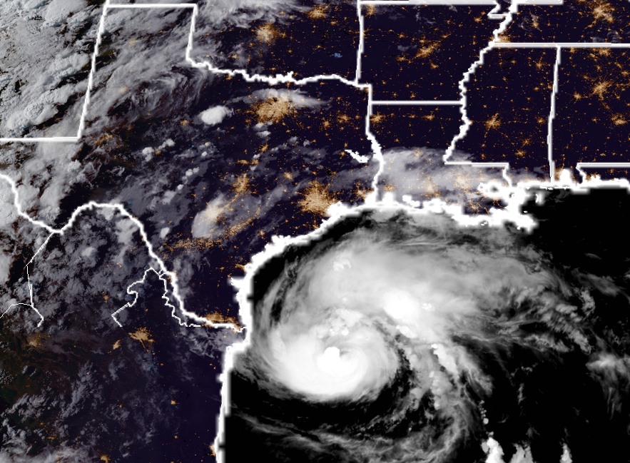
As of 8:00pm CT tonight, a well-organized Hurricane Harvey is moving northwest, toward the Texas coast. It packed 85-mph winds, but forecasters at the National Hurricane Center still expect it to come ashore late Friday night, or Saturday morning as a major hurricane. The most likely landfall location is between Corpus Christi and Port O’Connor. The storm’s strong winds and storm surge, likely at least 10 to 12 feet above normal tide levels, will pack a punch along the central Texas coast. For people in low-lying areas from Corpus to Freeport, these are potentially life-threatening conditions, and I urge you to heed the warnings of the Corpus Christi National Weather Service office and local officials.
For tonight’s post I wanted to discuss the most likely scenario for immediate effects in Houston, and then reconsider the uncertainty about what comes next. The National Hurricane Center anticipates that sustained winds on Friday night and Saturday morning in Houston and Galveston have about an 80 percent chance of reaching 39 mph, or greater. I think that’s possible, and certainly chances are higher southwest of Houston, in places like Sugar Land. However, at this point the available model data indicates that winds will be manageable in the Houston region during Harvey’s landfall. This is important for a number of reasons, not the least of which is that minimal tropical storm force-winds are something the region’s power grid should be able withstand. Mostly.
In terms of rainfall, the picture is more grim. It still appears as though the Houston region will see manageable rainfall totals through most of Saturday. That is not to say it won’t rain hard at times, and streets may briefly flood. But for the most part I don’t expect mobility to be greatly impaired. If this forecast changes, we will of course be all over it.
Now, looking ahead to the period of Sunday through Wednesday, uncertainty in the track forecast reigns. We’ve hammered this point for a couple of days, but the point remains that we can’t be sure where the storm is going to go after it reaches the coast. It’s like putting a bowling ball down in the middle of an alley—where will it roll? Harvey is going to be something like that. And unfortunately, for us to really get a good, solid handle on rainfall, we ultimately need to know where the center is going to go. Perhaps the best way to handle this is to spitball some probabilities. So let’s discuss three different scenarios.

The Euro special
Odds: 40 percent. Earlier today we discussed the European model solution for Harvey, which brings the storm into the Texas coast, stalls it, then pulls it back over the Gulf of Mexico and eventually into southwestern Louisiana. Under such a scenario, depending upon the track, much of the Houston area would likely get 5 to 25 inches of rainfall, with the greater totals closer to the coast.
The wandering 59 special
Odds: 35 percent. This solution is favored by many members of the GFS model ensemble, in which Harvey comes inland, and wanders around Corpus Christi, and the rest of the Valley until Sunday or Monday. Then it moves up the Highway 59 corridor, into Houston, over Beaumont, and off into Louisiana. Such a scenario would likely bring 10 to 25 inches of rain to much of the Houston metro area, but totals might not necessarily be greatest along the coast.
Dying in the Rio special
Odds: 25 percent. Not all of the GFS ensembles pull Harvey back to the north. Some stay in south Texas and peter out. NOAA’s new hurricane model, the HMON, has depicted such a scenario over the last few runs, too. The HMON forecasts that Harvey’s remnants burn themselves out in northern Mexico and southern Texas. Under this scenario Houston might get 5 to 10 inches of rain from Harvey—a lot of rain, but certainly manageable. If this happens, amore than a few people will be mad at meteorologists for having stood in line at grocery stores today, and now what they heck are they going to do with all these Pop Tarts?
Key takeaways
- A major hurricane is coming to the Central Texas coast. It will have bad consequences for that region. However the best available data as of Thursday night suggests the immediate impacts on Houston won’t be extreme.
- The unanswered question is what happens to Harvey once it reaches the coast. Where will it go, and will it go fast enough? Houston’s rainfall totals over the next five days depend on this, and we just don’t know.
- Big-time floods are coming to Texas. Certainly the Corpus Christi area and points immediately north and west of there will get too much rain. Flooding will spread to other parts of Texas too, quite possibly Houston. But right now we can’t say that for certain. As I’ve said, it’s either going to be pretty bad, or really really bad here.
We’ll have a comprehensive update early Friday morning.
Posted by Eric at 8:15pm CT on Thursday by Eric
You got any insight into San Antonio rainfall from this? Or someone who does work as good as yours for that area?
I can’t speak about and specific site, although one day I’d like to expand to central Texas, including San Antonio.
Right now we can’t rule out 5-15 inches of rain in San Antonio, but again this is highly dependent upon the track forecast. Which remains very iffy.
Thank you so much for the update on Harvey , I have a lot of family in Corpus Christi and my 2 daughters in San Antonio. They don’t like to worry me so its always nice to know what is going on .
Thanks. That was very informative
Thanks for being so candid very helpful most news media grossly exaggerate the news !!
Are you expecting serious delays for Sunday morning flights out of Hobby? Or serious flooding in that vicinity?
Great info as always. Your efforts to keep us informed with data-driven conclusions and a minimum of drama are much appreciated.
Agreed!!! Thank you!
Pretty bad or really bad…. that sounds just peachy
You want peachy? Ok. We are going to have some GREAT temperatures for late August.
=D
LOL! Post-hurricane cooling for the win!
Came for the calm and informative discussion, but staying for the snark.
It was pushing 9pm. I’d been up a long time. And was halfway into a glass of Cabernet. Couldn’t be helped!
I’m so used to Reddit – wanted to upvote each of the comments on this thread!
On a serious note, thank you, Eric, for your hard work!! Much appreciated and I try to share this page with anyone who’ll listen!
Best answer ever!!!!!
Loving that part of it!!!!
😬
Eric –
Thank you for having such a sane presentation of the information regarding our area’s weather.
We used to go to the NOAA site and look at Doppler radar locations around the US. Do you happen to know if those still exist in the NOAA site someplace? We looked and haven’t been able to find them.
http://www.nws.noaa.gov/radar_tab.php
https://radar.weather.gov/
Try that Emily. =)
Thanks.
Any thoughts on what the storm will do to Austin?
Eric, just curious, how much rain per day is manageable by Houston’s bayous system? Is it 6 inches per day? 10 inches? How much does it take to saturate the system?
I’ll go with 5 inches per day, and 15 inches over four days, as a threshold for widespread flooding. That is a guess, however.
Thank you for this. I guess essentially what you’re saying is that at this point, there is a great deal of uncertainty about Harvey’s track once it makes landfall, and it would be pointless for you to estimate rainfall totals in specific neighborhoods until the track becomes more clear. So, readers of your blog should check back for updates, listen to their local emergency management officials and prepare for significant rain, wind and storm surge with the hope that nothing unmanageable presents itself?
Brilliantly put. I mean, Harvey is absolutely going to flood a major part of Texas. It is not 100 percent clear to me that that includes Houston at this time.
Thank you for the helpful insights.
If the Rio special occurs, people should just keep those Pop Tarts ( and other less perishable stuff) for next time. The season still has a ways to go.
What is the likelihood of the storm spawning tornadic activity in the Houston area? Information I’m seeing other places online is contradictory on the topic.
Thanks for the great work, as usual. What needs to happen to offer greater certainty in the forecast, and is there a time when you expect that information will become available?
Great information. All we can do is hope. Meanwhile, have you ever seen a storm as unpredictable as this one? It seems to just be wandering aimlessly.
Thank you Eric for your words today. My dear Fulgencio and I will have our peaceful night tonight and eagerly await seeing what comes next. We are prepared with water and food and other necessities we need and have you to thank. Ciao!
As always we appreciate all you guys do for us in Houston to make sure we get the best weather forecast any where. You guys stay safe and do what you do to keep us informed.
Thanks again for all the good guidance on this kind of events. My question is relative to the rain totals and how the effects of Harvey could be compared, for instance, to those of the Labor Day 2015 flood?
I’ll take the 25% ! Any glimmer of hope helps!
Not the new we want, but it’s what we need. Keep us posted, we all appreciate the work you’re doing.
Thank you so much for your service. It is helping stay inordinately calm. I truly appreciate it. You’re a great writer.
Thank you for your consistent information without all the hype and fear. I will always appreciate the straight forward information you provide.
Eric, the work you’re doing is unbelievable. I can’t tell you how many other news and weather sites I’ve seen today calling this “the most devastating hurricane Houston has seen in a decade” or “more devastating than Allison.”
I like the facts, and the likely scenarios. What you give is truly hype-free. I love that you spend so much time and effort making sure your fellow Houstonians know the truth, and are prepared for what’s going to come.
Thank you, Lisa.
I agree!! As a scientist myself I so appreciate that you provide information and discuss scenarios based on the available data!! And present them in a clear and coherent way!
Could you be more specific of what you expect in the Ft. Bend county area? We are not used to flooding as much, even with a lot of rain, but we are much closer to the action than say downtown Houston. I’m trying to get a better understanding of what we should be prepared for here.
So grateful for your thoughtfulness, talent, and compassion for your readers. Thank you, Eric.
It sounds like we will be okay with the initial landfall, but do you think those in the Clear Lake/Friendswood area (near Ellington Field) should consider evacuating due to what might happen later under the Euro or Wandering 59 scenarios? We’re not too worried about street flooding (we can just stay at home), but would be worried if houses were going to flood.
Thank you so much for your frank and clear information, even when things are uncertain. I think we all wish we could have perfect, 100% accurate predictions from meteorologists, and it’s hard to deal with not knowing for sure how much to worry. But I understand that the science is just not at that point yet, and your posts are so helpful and down-to-earth. Please keep doing what you do! Very much appreciated!
So are the news channels being sensational saying 25-35 inches for most of the area?
I have a gathering at my house Saturday afternoon near Dacus (northwest of Montgomery). If we wrap up at 4 PM any guesses as to ability to get to homes in northwest Montgomery County and Grimes County? I know it isn’t a realistic question. My dilemma is Saturday afternoon vs evening. Thanks for your posts. Debra
I’d press ahead at this point, on the assumption that there’s a reasonable chance of passable weather. Obviously if things turn ugly Saturday morning, you’ll have to cancel.
If Harvey follows the Euro Special scenario and shimmies up the coast, would the threat of a steady storm surge prevent the bayous from draining effectively?
That is a concern, but under that scenario Houston would be on the “left” side of the storm, with winds blowing from north to south. This should help drain bayous. Theoretically.
There are reports going around Houston that the local news media are hugely underplaying the likely severity of Houston flooding to “curb widespread panic”. According to these reports, there was a meeting today (Thurs) with Army Corp of Engineers and area Flood Control Districts, where it was agreed that flooding in Houston will be “catastrophic” and most of Houston will be without electricity for at least three days. In your view, is the local media coverage reasonably accurate and something I can rely on in making decisions on leaving or staying in Houston? Thanks.
That is a fake email that has gone viral. Disregard.
Mmm, that is exactly what the mass media would say to curb widespread panic….
Just kidding, just kidding….
Thank you for pulling that together sans hysteria. All the headlines are making me a nervous wreck and I’m cussing at my phone. (Again)
Do you know how the predicted Harvey storm surge for the Surfside Beach area compares to that which they experienced with Ike? I can only find surge data for the “dirty side” of Ike.
Eric- When you say up to 25 inches of rain, how many days does that span?
Mostly Sunday through Tuesday.
Thanks, Eric! This is one of the more optimistic forecasts I’ve seen lately for Houston
What do you think will be in store for Kemah?
Thankyou
I’m assuming Bush ICA will be a normal stormy Saturday evening?
Thank you, Eric.
Are tornado’s a possibility, if so, how severe?
What are the odds I will make it into the medical center (from Pearland) Saturday morning? And OUT of the medical center that night? Should I pack a bag?
What are your thoughts on New Ulm, Texas rain totals for Sat&Sun?
Saturday night is fight night. Will the rain/winds be bad enough outside (The Woodlands) to have to watch it at home and not go to the bar? Thinking the fight starts about 9:30, finishes about 9:40, and back home by 10:30.
Are we going to be able to go to sleep on Friday night without worrying about waking up to water on the floor? I know the answer is no on Saturday and Sunday and maybe Monday….but can we get a good night sleep on Friday?
That satellite image of the hurricane with the visible lights in the city areas is really stunning!
Thank you Eric for the update. Actually we go waaay back to the days when people used to ask if a place which shall go unmentioned should evacuate. This came up on a blog I frequent. I hope you, your wife, and daughter are doing well!
Fifty
The next person to ask about flight delays will be put on the no-fly list.
Yours with great annoyance,
Jeff Sessions
Attorney General
A federal judge somewhere (district 9? Hawaii? Corpus Christi?) strikes your ruling down under the ‘since when did you get standing in the department of transportation?’
Chuckling…
What are the odds of my husband being able to fly out of Houston Hobby at 7 AM on Saturday? Rough estimate based on whst you expect?
Hello, thank you for all of your updated info. It is very detailed and appreciated by family in Canada.
Thanks so much for all of your hard work to keep us informed!
Any thoughts on the Alvin/Manvel area….rainfall and flooding?
Any thoughts on impact to Colorado County?
What are the chances that my husband will be able to fly out of Houston Hobby at 7 AM on Saturday?
Thank you so much for your calm, factual, honest assessment! I just heard about you today and you are wonderful!
I heart your geeky butt, Eric. I just flat out heart you. BUT really, there’s no such thing as too many Pop Tarts. Have you tried the Jolly Rancher Cherry flavor? O.M.G. Keep dry!
How do.things.look.in houston 77090 first time, realllly scared
Thank you for your straightforward weather reports sans all the ridiculous hype!! It’s a welcome change.
Eric
Thanks so much; I have been following Yku since Chronicle times….the best weather guy…on vacation in Europe and following your excellent coverage
Thank you Alex!
Love your style. We need more of that in the media (and less all-caps theme graphics). Any way we can get it to come up here to the Hill Country and dump all those 25 inches into our low lakes? Via HAARP or and artificial Low right around Amarillo? Thanks!
Thanks Eric,
The information you provide is excellent and when friends call and ask for an update on the weather, I send them your information.
OMG I just moved here from North Texas 5 months ago and was doing the whole shopping thing for prep food and i called my Mom telling her wow there’s no bread, no vienna sausages, then i got to the Pop Tart isle and NOT ONE BOX OF POP TARTS !! Wait why pop tarts lol?? Im so confused lol
How long will the storm surge stay inland? And how does that affect the rainfall we’ll get?
Most likely it will not have a big impact, because the surge should be over before the heavier rains arrive.