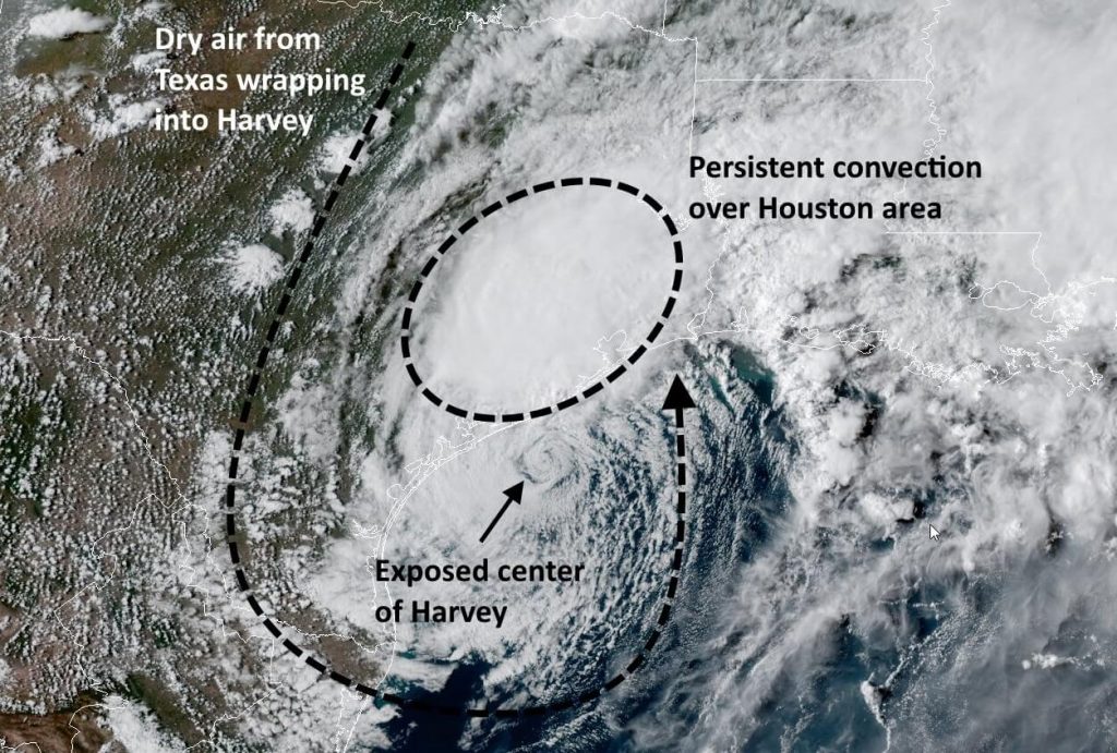
Monday, 6:15pm CT—It’s been a wet day across an already waterlogged Houston, and unfortunately we can probably expect similar conditions to continue through the night. During the day we have seen a lot of dry enter into Harvey’s circulation along its eastern side, but unfortunately this has yet to substantially affect the convection on Harvey’s northwest side—which just happens to be continuously dumping rainfall on Houston.

This pattern has allowed Harvey to drop 3 to 8 inches of rain across most of the Houston metro area during daylight hours today, with the heaviest rains in northern Brazoria County and Southern Harris County.
Because Harvey is only moving to the east-southeast very slowly, about at the pace of a slow walk, we can probably expect this pattern to continue for tonight, and into Tuesday morning. For the most part these aren’t excessively heavy rains, but even rainfall rates of 1 inch an hour will cause bayous and floodwaters to rise if they persist long enough. Therefore, while we don’t expect floodwaters to rise rapidly tonight, steady, moderate rains could cause slow rises in bayous. This is about exactly what the Houston region doesn’t need right now.
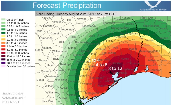
As far as accumulations, the National Weather Service predicts that the following areas of Houston could get as much rainfall as the amounts shown in this graphic during the next 24 hours, through 7pm Tuesday. I’m hoping these totals are little high, but we can’t rule them out.

Looking for some good news? We have a little bit of that. The favorable area for tornado formation is moving to the east, so we should have fewer tornado warnings tonight, and then fewer to none on Tuesday. Also, we feel fairly confident that the potential for prolonged, heavy rainfall will end sometime on Wednesday, during the afternoon or evening hours.
Matt will have another update later tonight.
Posted by Eric at 6:15pm CT on Monday

I have enjoyed your updates but am almost having to force myself to open them at this point😢Just can’t take much more of this! BUT truly appreciate them
Can I just say…. THANK YOU SO MUCH and… Weather fatigue… Wednesday… Oy
Thanks for such terrific coverage. Much appreciated!
Cypress Creek is already so high–11 feet over its banks in the Champions area–that more rain cannot cause it to rise much more, since the 500-year floodplain is so immense. (Where it crosses Stuebner-Airline, Cypress Creek only rose about 6 inches between midnight and 6pm today despite the tremendous rains that have fallen upstream. But the rain can keep the creek from dropping as so many homeowners up here would like. There are more flooded homes in my neighborhood than since it was built in the 1970s.
Ugh, watching Cypress Creek also. I evacuated Galveston to my folks’ house in Cypress (Louetta/Grant). Lakewood Forest is becoming more of a lake. Faulkey Gully is getting up there when we went to take a look earlier. The rain has literally not stopped all day today.
I’m glad we still have power. *knocks on wood.
Thanks Matt and Eric for the updates. Looking forward to ones with sunshine!
Hype free forecast indeed! This is a breath of fresh air.
Still hanging on every word. Granted not all are good news but at least I know what, when and where the weather is going to be. Thanks for the Herculean effort. It’s been appreciated.
As long as it’s needed with this storm, we’ll be here.
We live in the Atlanta area….a Huston friend shared one of your posts and I have followed since day one. (We have friends in the Houston and Lake Charles and surrounding areas.) Just want to say I am impressed with both you and Matt. Wish todays world could take lessons from “who you are, what you do, and HOW you go about your responsibilities!!!!!!” I AM MORE THAN IMPRESSED!
You guys are keeping me sane.
Thank you for keeping us so well informed. Do you think the highways are safe enough to drive from Clear lake area to Jersey Village area tomorrow?
Keep an eye on Transtar for that—they’re tracking high water areas still, and you can use the road cams to see what the areas look like.
http://traffic.houstontranstar.org/layers/
Personally not too positive about driving tomorrow.
Appreciate your no nonsense weather reports
Keep up the great work
You do a fantastic job of reporting. God bless you!
Thank you for everything you’re doing. You’re a huge help and you’re doing an enormous public service. Wishing you a very long and well-deserved sleep when this is all over.
I’m in Nashville, TN, where we lost everything in the historic floods of 2010, with my heart aching for my hometown of Houston. So thankful for your updates and perspective. Houston will recover, but I know how very hard it will be to dig out.
You guys deserve some much needed rest when this is done. You and your families are in my thoughts and prayers. Outstanding job.
We’re still in south Louisiana trying to drive home to Houston. Any ideas about when we could possibly get safely home and when the roads will be passable?
Anne, go to https://drivetexas.org for as close as you can get to complete, real-time information on road conditions in Texas. It is excellent, and it covers everything from Farm-to-Market roads to interstate highways. It tells where roads are closed, where roads are open but covered with water (travel discouraged, but not closed), where construction is going on (especially useful if there’s a bridge out), and where roadways have been damaged. Come to think of it, it will also tell you where roads are blocked by debris. So it’s really comprehensive.
Safe travels!
Thank you so so much for your wonderful and straight forward updates.
What is the status of the reservoirs- will creeks and rivers add to the water levels there and continue to pose the threat of a breach?
As of right now (Monday night, 8:30pm CDT), CNN is breathlessly reporting that Harvey is “poised” to hit Houston again in the next day or so. This is what I believe you have been calling the “Zombie Hurricane” scenario. Do you see any greater likelihood of this occurring versus what you believed this morning?
Eric, the western side of the storm ( Katy/cypress area) seems to be dissipating as though the dry air is choking out sustained heavy rain. This looks like it may be the end of even 0.5″/hr rain rates on that side.
Yet the map shows 4-8″ total through tomorrow? Is there an expectation of buildup in the models that we’re not seeing?
Eric, I’m gonna miss you after all of these days together…let’s stay in touch after this is all over, okay?
Me too! Plus I want to buy these guys a few rounds.
Fantastic information all week cannot thank you enough for your writing style.
A major anxiety that many of us are having that the local news does not want to talk about is the major risk concerning the Addicks and Barker Reservoirs. Do you have any information regarding what would happen if these dams were to fail?
Floodwater is now starting to expand west from the sides of the reservoirs toward many suburban areas, where homeowners were under non-mandatory evacuation alerts.
The two dams were built some 70 years ago that didn’t have the development we see today.
From Dr. Jeff Masters:
The reservoirs are usually empty, the dams have experienced a sequence of increasingly frequent on-and-off strains due to increased development and more-extreme rainfall events in the Houston area. In 2009, the USACE rated the Addicks and Barker dams as being at “extremely high risk of catastrophic failure,” which put them among just six dams in the nation with that designation.
It’s important to note that Addicks and Barker have not been considered at imminent risk of failure, according to USACE, who say the designation hinges in large part on the scope of the disaster if failure were to actually occur. As reported in the Houston Chronicle last year, “If the dams failed, half of Houston would be underwater. Under the worst scenario at Addicks, property damages could reach $22.7 billion and 6,928 people could die.”