Before getting into the forecast, let me just say that Harvey remains an unpredictable system in terms of intensity before landfall, and especially its track after landfall. This creates considerable uncertainty in the forecast. What you’ll find below is our best attempt, but conditions will change, and so will the forecast. As always, we’ll remain on top of it as best we can—because like you, we’re making critical decisions about travel, our families, and our property.
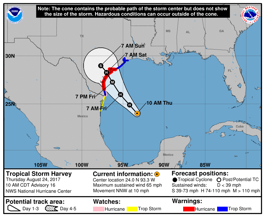
Harvey has improved its satellite appearance markedly this morning, and a reconnaissance aircraft found the storm’s central pressure had dropped considerably. The system now has 65-mph winds, and as it passes over warm water there is little to slow down intensification of the system prior to landfall. Because the storm has gotten its act together, and still has about 36 hours over water, the National Hurricane Center has amped up its wind speed forecast considerably. Harvey is now anticipated to come ashore with 115-mph winds, just over the threshold of Category-3, or major hurricane status. Here’s the 10am CT track update from the hurricane center:
Winds
Now that Harvey appears to be rapidly strengthening, we need to carefully consider the wind impacts of the storm. Winds are always highest on the right side of a hurricane, where the counter-clockwise rotation drives wind and storm surge inland for maximum effect. Therefore the location of the storm’s landfall is critical. Right now the hurricane center forecast predicts a landfall between Port Mansfield and just north of Matagorda. Such a landfall location translates to the following probabilities for sustained, tropical storm-force winds:
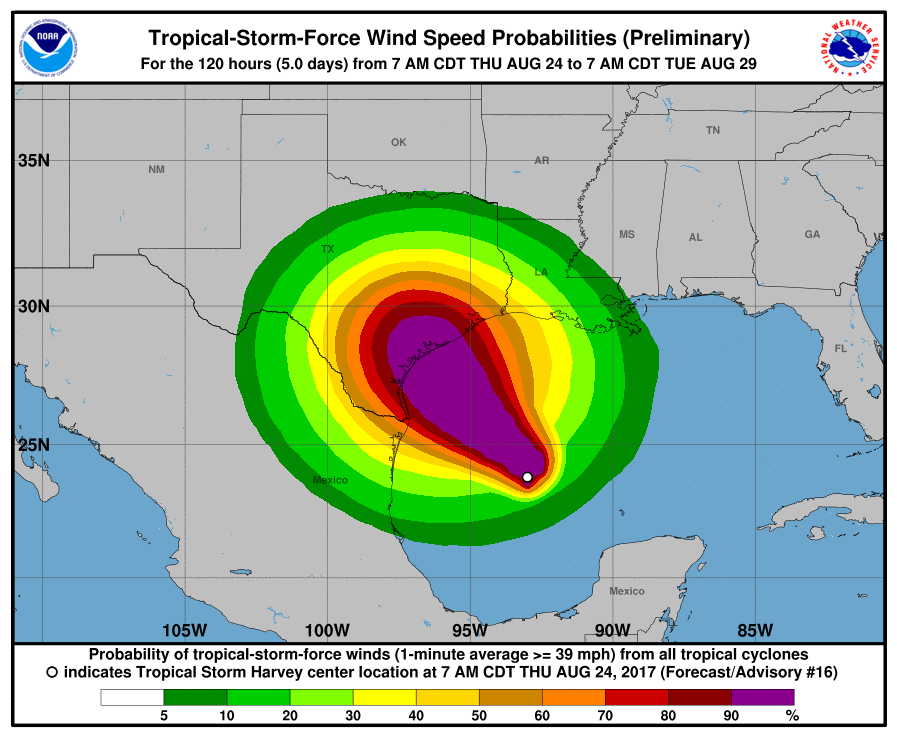
For the greater Houston area, this translates to about a 70 percent chance of TS-force winds, 39 mph or greater. This probability has increased due to the strengthening of Harvey, and it would increase further if Harvey takes a more northerly track toward Matagorda. The current probability of hurricane-force winds in Houston and Galveston is presently less than 20 percent, so I’m hopeful we won’t see anything too extreme.
As for timing, we can expect these winds to arrive late Friday night or Saturday morning, but certainly both days will probably be gusty for the region. After Harvey moves inland on Saturday morning, the winds should slacken some over Houston.
Surge
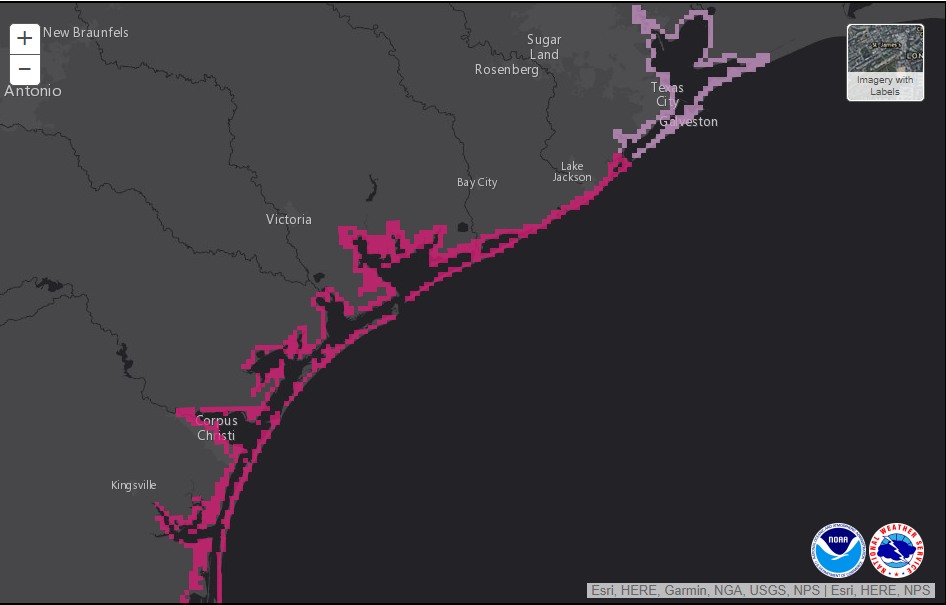
As Harvey strengthens, it also becomes more capable of producing a significant storm surge, which is dependent upon both the size and intensity of a tropical system. The National Hurricane Center has posted a storm surge warning for the following areas of Texas. The greater Houston area is under a watch, which means storm surge flooding is possible. I think we can at least expect low-lying areas, including Bolivar Peninsula, to be threatened during the next 48 hours. Obviously, should Harvey takes a more northerly track, we’ll need to be more concerned about storm surge for the Houston area.
Rains
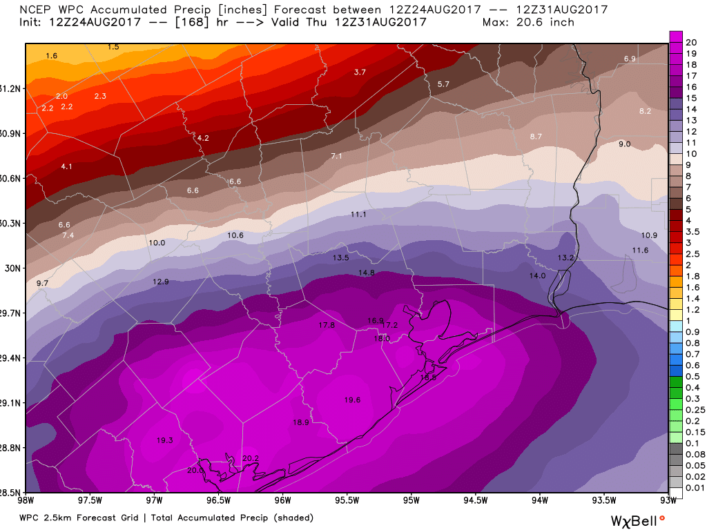
Long term, of course, inland rain and significant flooding remain the dominant concern for Texas, including the Houston area, as Harvey is expected to stall once inland. We’ve been reluctant to post rainfall forecasts from individual models, because some of the totals have been really extreme (and it’s best not to trust individual model runs). But now NOAA’s Weather Prediction Center has started to put out accumulated precipitation forecasts to reflect the threat between now and next Wednesday. Here’s their latest forecast for Houston:
And here’s the same forecast for the greater Rio Grande Valley area:
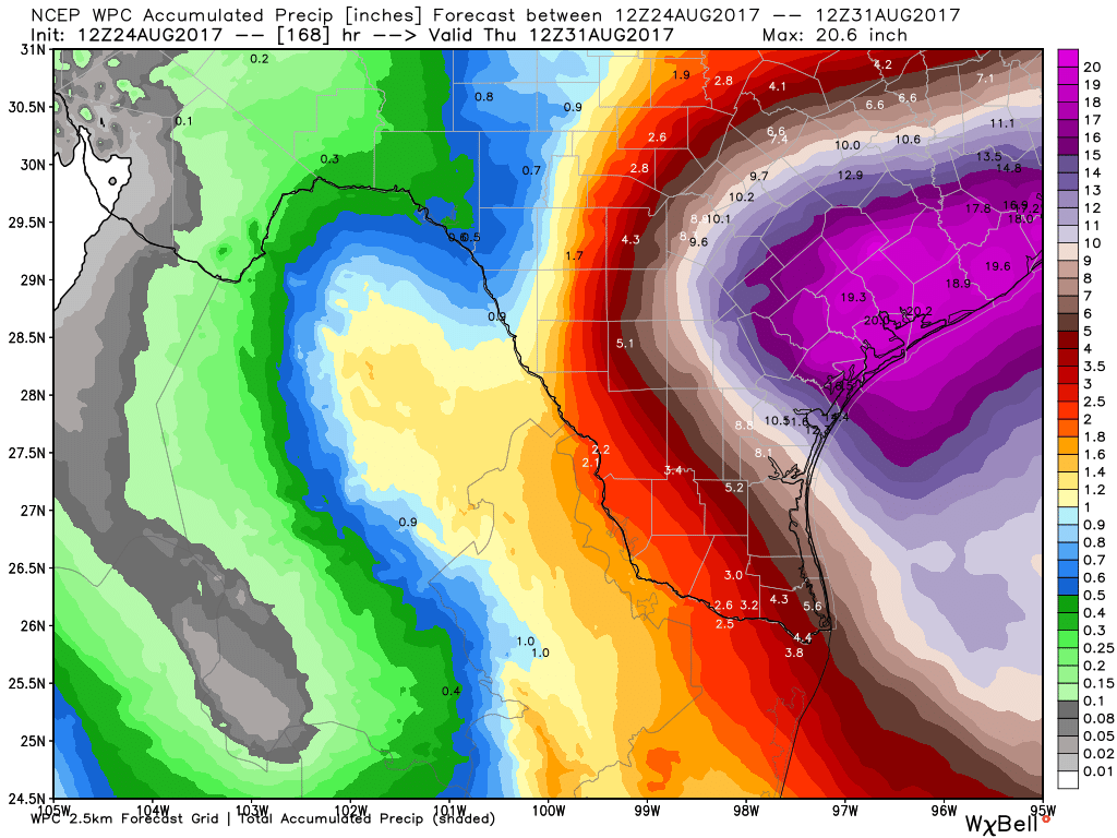
What you need to know is that these maps are far from gospel, and the forecast is likely going to change. But they’re nonetheless illustrative of the kind of very serious flooding threat that coast Texas faces over the next week. Also worth noting: Some areas will probably receive greater rainfall totals than those displayed on these maps.
Key takeaways
- Harvey is rapidly intensifying, and now poses a significant storm surge threat to the central Texas Gulf coast.
- Tropical Storm force winds are possible in Houston on Friday night and Saturday morning
- The strongest rains from Harvey probably won’t reach Houston until later on Saturday or Sunday
- Although there’s considerable uncertainty still, most of the Texas coast, including the Houston-Galveston area, faces a significant flood threat over the next six days.
We will update again at around 2:30pm CT.
Posted at 10:30am CT on Thursday by Eric
Harvey is not very co-operative. And they women are unpredictable……
Harvey is a guy’s name 🙂
On the contrary. About a week ago models showed a potential impact on the north Texas coast. Harvey is only about 200 miles west of this early prediction. Considering Harvey’s track over land I find that quite remarkable.
A few days ago forecasters started to ramp up Harvey’s Rapid Intensification Index, apparently the models picked up on the storms rapid organization.
The storm track has moved further north, do you think the track will continue to fluctuate in that direction, or do you think that zone between Corpus and Victoria is still more probable?
I would not bet on further northward motion in the track forecasts, but I wouldn’t entirely rule it out either.
Great article keep us updated!!
Thank y’all for your knowledge and updates for weather in Houston TX.
Y’all are precise and informative.
I love space city weather. 👍☝️
How is Saturday morning looking now for flying out IAH ? Thanks for these updates
Did you read the post? It tells you exactly what the likelihood of strong winds are for Houston. No one can give you any more than that at this point. Contact your carrier.
One thing I’ve noticed in 20 years of Gulf Coast living is the the forecast 3 days out ALWAYS changes. Sometimes good, sometimes bad. Hoping for good in this instance
Y’all are my go-to for the next several days. Keep up the good work and keep the updates coming..
Y’all are the best for level headed information in times of mass hysteria!! Thanks for everything!
Quick question about the rain:
It’s my understanding the flooding won’t be as bad as Allison, however, could the flooding in Houston be potentially worse than April 2016?
I have a really silly question. I need to mow my lawn this afternoon as it’s a bit long and we’re not going to have an opportunity the next few days, by the sounds of it. Obviously, I need to mow the front for the HOA. But would a long yard or short yard in back be better for helping with water control? I’ve been mulling this over for a little bit and just have no answer. Or (more likely) is this just one of those things that really doesn’t matter in the grand scheme of things? In which case, the “don’t mow the back” wins out because procrastination always pays off before hard work 😀
I have no idea which is better for flooding, but I know a kindred spirit when I see one. I’m pretending that the piles of unbagged grass clippings in our back yard are strategic, not just the result of running out of steam before I finished the job. 😂
Cut everything now so it won’t he enormously long by the time the ground dries out enough for you to run the mower again.
So weatherchannel.com is reporting the storm could strengthen to category 3. Is that possible?
Did you read the post? “Harvey is now anticipated to come ashore with 115-mph winds, just over the threshold of Category-3, or major hurricane status.”
Eric & Co. thank you guys so much for your tireless work & keeping us updated. Your website it by far the best and most comprehensive! Thank you!
Might there be any correlation between a hurricane’s strength at landfall and its likelihood of backing up and heading up the coast?
Dag-nabit, I just confirmed my business trip for tomorrow and reserved the hotel, then saw this. Now I’m thinking I jinxed it! 😀
Practically, though, doesn’t the strengthening of a storm usually tighten it up, meaning wind-wise we’re less likely to see the rough winds than if it were a weak Cat 1 or TS?
if flying out of hobby saturday morning, would it be smarter to change flight to friday night?
Living near Addicks Resevoir right off I10 and Barker-Cypress, what precautions should be taken? I was planning on leaving my car at higher ground over the weekend in a further south area of Katy, but can reconsider if needed. I live in a 2nd floor apartment. I’m new-ish to Houston (from DFW) so I am not used to this and have only just moved to the Barker-Cypress area.
That area pretty much always floods because of the soccer fields and being lower in that general area. Check with your apartment complex and ask them if their parking lot flooded during the Memorial or Tax Day Floods. Keep in mind that whole area normally becomes impassible at Saums/S Parkview/Greenhouse during any heavy rain event. So even if you’re apartments don’t flood, you won’t be able to really get out and go anywhere if you’re closer to Mayde Creek than I-10.
Welcome to the south coastal prairie!
If you are south of Mayde Creek HS and near the soccer fields (Greenhouse and Barker-Cypress), this area likes to flood from any sustained rainfall.
You make find the Harris County Flood Warning Service to be useful. Zoom the map to your area. The gauges listed are clickable. You will find rain data and stream level available there.
https://www.harriscountyfws.org
If you haven’t discovered the Transtar site, they are useful for main road conditions.
http://www.houstontranstar.org
Both sites have active twitter feeds.
Eric–flying to DC on Friday night and returning to IAH Sunday night. Should I cancel the flight or does the real rain event begin on Monday or early next week?
Given that Harvey is looking like a category 3 on arrival, seems like we are <150 miles of coastline away from the Houston nightmare scenario (cat 3+ with landfall SW of Galveston, storm surge taking out Galveston County/ship channel). At this point, any possibility of the track shifting northeast enough for that to happen?
Supposed to be traveling from Laredo to Houston Friday, Saturday, or Sunday. Is there a time that’s best to make that trip, or am I better off postponing?
Hey Eric,
Thanks for keeping us all up to date. We are planning on flying out of IAH around 6:40 PM to Mexico City tomorrow (Friday Aug. 25), do you think we’ll be affected?
What does this mean for Conroe?
I better make another trip to Spec’s…
Thank you as ever for your excellent and conscientious efforts and reporting. Do you have any thoughts on threats to power/electricity in Houston with this storm? (Hoping everyone keeps their lights on, or duration of any outages will be short!! I know you’re not in charge of CenterPoint…)
You may find up to date outage information for Centerpoint here:
http://gis.centerpointenergy.com/outagetracker/
Think Flying to houston Friday afternoon is ok?
How many inches of rain did they Houston area get during Allison? recent tax day flood? memorial day flood? Just trying to compare it to something. Thanks.
During Allison, Houston got about 39 inches over 6 days. Tax day floods were – on average – 7.75 inches in Harris County, BUT the rain fell fast, up to 4.7 inches per hour. Memorial Day flood was about 12 inches over 10 hours.
We were planning on driving from San Antonio to Houston late Saturday. Do you think there’s still a window of decent weather for travel based on the latest update? Thanks for your great work!
Exceptional reporting sir. I just saw a forecast map from the NOAA that shows Harvey to still be to the west of Houston Tuesday morning at 7:00 AM. Could we potentially be looking at Harvey to still be around Houston on Wednesday/Thursday? I understand that these are educated opinions and not fact.
Keep up the good work.
Man I have a trip planned to new braunfels leaving Friday morning coming back Sunday morning. I’m not too worried about winds. My concern is timing on being able to get back near Angleton before the rain gets too bad.
Quick question about the rain:
It’s my understanding the flooding won’t be worse than Allison, however, does it have the potential to be worse than the April 2016 floods in Houston?
If you were a parent sending her kid abroad for a semester, which day would you change her flight to? Tomorrow or Saturday? She is slated to leave Sunday and HAS to be there Monday.
Hello
Sigh. I’m supposed to fly out of IAH Sunday afternoon. It doesn’t flood around my house (Pearland), does it typically flood around the airport? Will they cancel flights because of flooding in the greater Houston area?
Love the website!!! I keep reading 12″-15″ in the Cypress area. I want clarification please, that rain total is over the entire event (days). Not each day. Correct? Unlike, the Tax Day Flood when Cypress received 16″-20″ of constant training rain in 10 hours, huge problem.
Oh man, Eric. Thanks for the updates. My flight gets into Hobby at 9:30pm Saturday night. Is this new updated forecast showing that that a flight that late on Saturday is likely cancelled?
Thanks you guys for your objective reports. When you start to get worried, I know to get worried. Thanks for the frequent updates at well!
I am on the north side of Houston, and to me 15 inches of rain spread out over several days does not seem quite as scary. We recently had 8+ inches in one night. Will the rain come and go as the storm comes through, or would it more likely be a constant non-stop event where the drainage can’t keep up? Thanks for what you do!
Same here, I am in Spring and seems if that amount is over the long haul ,then should be fine. My concern is power outages for extended periods of time. Get the beer iced now!
Thank you as always!
Hi Eric, Matt, and Braniff- thank you all for your posts. It is nice to read such thorough information amidst all the news stations. Can you advise if you think flights will be able to leave IAH early Friday evening still? Or projected bad weather already at that time? I assume flights may be canceled or up in the air back into Houston on Tuesday or Wednesday next week. Thank you again for all you provide to the Houston area!
…Jim Cantore is in Galveston! Eek!
Back in the day of an earlier century, this would be the Dan Rather (of KHOU-TV) tied to a wooden power pole near the Galveston beach during Carla.
Enjoy from a safe, secure distance. 😉
Thx for the updates/ y’all are performing a valuable service to our communities
You think brazoria county should be a hurricane warning as well?
I still forecast a matagorda bay landfall.
Now the news and local law enforcement is saying we might just get rain. Doesn’t seem that bad at all.
Eric, I am in Oklahoma and needed to drive back to Houston no earlier than Saturday evening but no later than Sunday evening. I am concerned that I won’t be able to time my drive within that window so as to get to the city while the roads are still open.
Naturally, I can’t ask anyone at this point to give an hourly forecast three days in advance, but I would appreciate your best guess as to whether most neighborhoods in the county will be navigable on Sunday. Do you think we’ll be facing an “earlier is better” type of situation, where things will progressively worsen until Monday, or do you think flash flooding will be a risk come Saturday evening/Sunday morning?
Thank you for your thorough, clean, reliable analysis as always.
What should people in Freeport be doing? Would it be unwise to evac if you have two little ones and the possibility of it taking more of a right hand turn and making landfall more towards Matagorda.
Thank you Eric. I found you during Hurricane Ike, and haven’t left you since. 🙂 Hype-free, just the way I like it.
Supposed to move our son back up to UT-Austin on Saturday morning and have to be there by 8am. They haven’t said anything about any sort of contingency plan yet. Do you think we will be able to get there, or should we call and start yelling, lol?
We are in Timbergrove with 3 little kids. Starting to wonder if a trip to Dallas would make sense. What’s your opinion on Houstonian evacuation at this point?
Karen,
I live in Timbergrove as well. One question: do you know if your home flooded in Allison? That was the only weather event that has significantly impacted our area since it was built in the 1950s. Provided your home didn’t flood in 2001, you are probably just fine.
Eric –
The computer models used to be on the NOAA site, but now I can’t seem to find them. I know you are busy, but if you get a minute, can you tell where I can find them??
Thank!
HISD has just cancelled all activities on the first day of school,
Monday 8/28.
Thoughts and prays. I evacuated my Katy home on Monday to make sure I was well away from the area
Does the current rainfall forecast signal a “worst-case scenario” for Houston as it stands? We often worry about quick, torrential rainfall amounts flooding bayous in the summer (2″+ in an hour for a couple of hours like we saw in early August)… but will 10-15″ of rain even over the course of 3 days strain the bayous like during TS Allison?
Not quite worst-case (that was Allison). It may get there, but for now I think it’s a notch below.
I’m so terrified of wind in Pearland I’m beside myself. Stay or go stay or go stay or go 🙁
Thanks so much for the updates, Eric. We love all your hard work and y’all stay safe as well!!
Is there a map that show rain totals that you can toggle day to day. Start with now plus 24. The toggle to now through 48 etc. That way you can see differentials by area or individual daily rain rates.
Eric, I noticed some of the models now bring it back out over the gulf and buzzes us right up the coast. Under this scenario do you believe it could re-strengthen and hit us?
Will flying into Hobby late Friday evening be feasible?
Thanks for the hype free updates. I’ve got a flight out of Bush Sunday afternoon. I’ll be watching the blog as things progress.
My wife and I are departing IAH around 10AM Friday morning. Will the weather hold out long enough to get off the ground?
Thank you for your forecast. We’re scheduled to come down from the Abilene area on Saturday, leave Sunday. (We’ll be staying at the holiday inn way down by Kahala Beach.) Yes? No? It feels insane to me to try to beat the rains on the way in, then “hope” we can get out on Monday or aren’t under a mandatory evacuation in between. (Or face other flooding threats during any number of possible routes home.) It’s killing me that Texas A&M still hasn’t made a determination on move-in weekend, or whether classes will start Monday as scheduled, so I’m getting desperate for guidance. 🙁
I wouldn’t come.
Thank you, that’s my gut feeling as well. TAMUG finally decided to cancel all University activities Friday, including move-in… But is “monitoring the situation with regards to the first day of classes on Monday.” Extraordinarily helpful when we’re 7-8 hours away on a good day. lol Stay safe!
I’m concerned about the latest run on the European model – basically having Harvey restrengthening on Monday and following the Texas coastline to LA. Is there still a lot of uncertainty as we move into early next week even after it now has formed into a storm?
I have a silly question: I need to mow the lawn today. The front has to be cut, HOA and all. But the back – is it better to be long or short ahead of a major rain event? Or is there no difference and it’s just me trying to get out of mowing half the lawn (procrastination always pays off now)?
I live in Katy and am fully packed. How many panties do you recommend i take?
What are the chances of my wife’s flight from Dallas arriving to Hobby on Saturday evening ?
Great info team!! I live near West Park and 99…inside Barker’s levee.
When do they close the dam (damn) gates?
How bad will Cypress be affected?
Thanks!