Just a quick post to note the official redevelopment of Harvey as a tropical depression in the southern Gulf of Mexico. The forecast track mirrors what we’ve been discussing for a couple of days now—the movement of a tropical storm into the Texas coast, after which its slows down, and drenches the eastern part of the state.
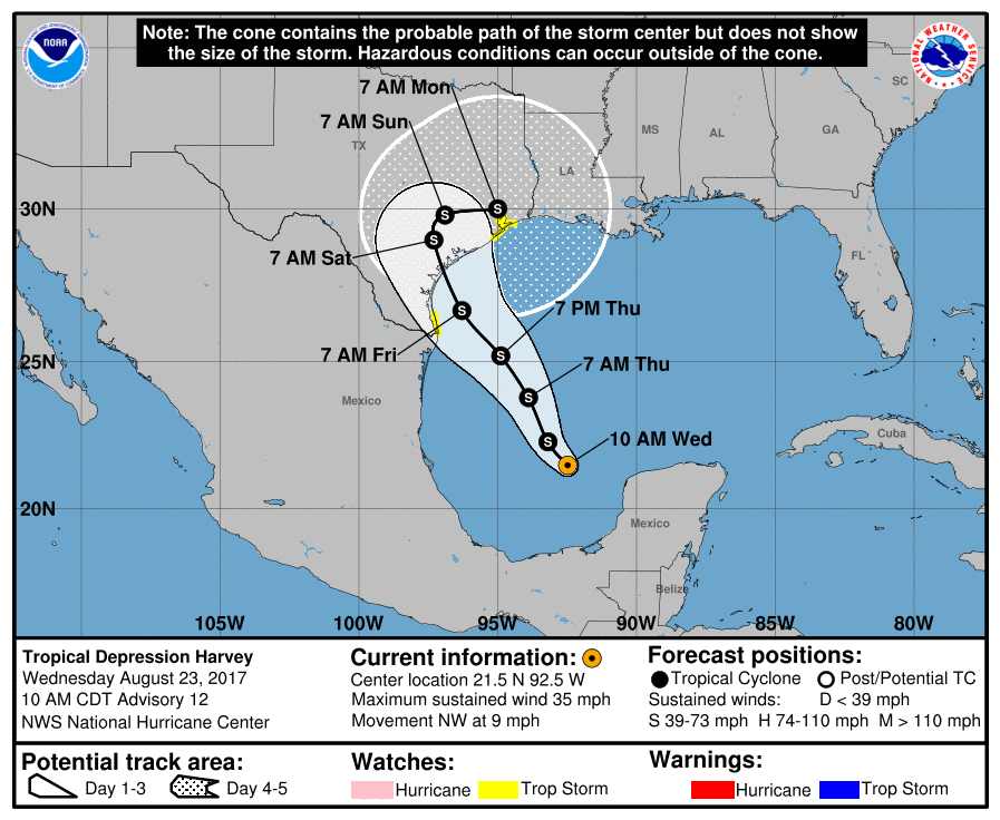
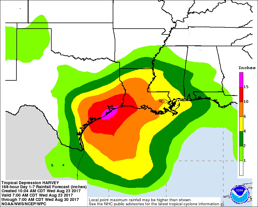
The official forecast predicts Harvey will reach hurricane strength—barely a Category 1 storm with 75mph—before it reaches the Texas coast. Tropical Storm watches are in effect for Galveston and the Galveston Bay area. Hurricane watches are in effect for Brazoria County, and areas southwest of Houston. But the primary concern with this system remains widespread rainfall and inland flooding. The hurricane center’s rain forecast for Harvey reflects this:
Our forecast from this morning largely holds up, as it is based on similar model data that made up the National Hurricane Center’s outlook. We will post a more comprehensive update this afternoon, around 2:30pm. In the meantime, here is what Matt and I feel you should bear in mind about the next several days.
- The rainfall hype is real and serious, and although it’s impossible to specifically forecast it at this time, you need to be aware of the threat.
- The forecast is going change, and in systems like this trying to pin down who gets maximum rainfall is extraordinarily difficult. Patience required.
- The rains will be spread out from Friday through Tuesday, but for Houston we continue to expect the heavier rain during the latter half of that period.

How much do you think Aldine area will have? Trying to decide if we should go to higherground
There is no way to tell at this point, way to early to make predictions
How much rain do you think the Aldine area will have? Deciding if we should leave or not
Do it now!
Thanks for these frequent updates. A great help!
Eric, we are supposed to be flying back into Hobby early Saturday evening – do you think we’ll be able to drive home to the Heights around 6pm?
I would think so, yes.
Thanks so much–you and Matt are always the voice of reason and you are very appreciated!!
Thanks so much for your information. You’re the best
Is this likely to be a “training” type rain event?
Yes.
When does the rain begin? Friday morning?
Yes, probably. But the heavier rains wouldn’t come until later, perhaps Saturday or Sunday.
Hey Eric. I see you mentioned over at Chron.com Glad to see they have enough sense to still reach out to you when needed!
http://www.chron.com/news/houston-weather/hurricanes/article/Tropical-Storm-Harvey-Houston-Texas-hurricane-11952567.php?ipid=bncollection
Thanks for your updates.
I agree – that was a nice “gesture” by the Chronicle to call attention to this site!
Thanks for keeping us updated. What about someone driving home and back from College Station this weekend? How far do we expect the rain and flooding to go?
Impossible to say. Certainly there are some scenarios in which College Station gets 10+ inches. In others it gets considerably less.
Hi guys, thanks for the info. In the last post, you said that it’s not really known what triggers rapid intensification. Of the factors that are known, what’s in play here? Also, what gives the NHC confidence that intensity will stay low, given the high SST and intensity potential in the Bay of Campeche?
Right now it has a poor structure for a tropical system. If/when it starts to get organized, fairly rapid intensification could follow. But when will that happen? Have to watch the satellite images.
I will be delivering home meals for the hospital in Clute, Friday from 10:00-12:00am. Heavy rain shouldn’t start before then, right?
Thanks for all you do. Read your column in the Chronicle for as long as it was there. Sure do miss it, but the email is great!!
Probably ok Friday for that.
How do you think the airports will be effected? And in what timeframes?
They probably will be, but hard to say when, for sure. Sunday-Monday seems most likely.
What is the suRfe for Surfside Beach??!
Okay, somebody’s got to break the seal:
“When do we evacuate Katy?”
Now that’s out of the way, the frustration sets in: we all know which areas of town flood. It’s now a question of which ones will get it and when.
My mom and grandmother are panicking after watching the news. My reply is always the same. “We can’t worry about what the news says; we have to go see what Eric says.” Thank you for the sensible post and for not causing fear. I appreciate your straightforward, honest approach to weather.
Prospects for long run Saturday morning in heights/River oaks area? (Kenyan Way group usually goes out unless lightening.)
Probably OK.
We centerpoint energy customers still haven’t heard back from you regarding power outages. Our concerns are as follows:
1. MASSIVE citywide power outages due to winds.
2. CenterPoint Energy is unable to respond to those outages due to floodwaters.
3. Multi-county power outage that could drag on through Christmastime!
Please assure us none of those things are gonna happen!
I would bet against any of those happening, but wouldn’t rule it out.
Any chance of San Antonio/Hill Country getting some of this rain? Could use it.
Yes. Be careful what you wish for.
We have a large company event to attend Friday 1-10pm. in Corpus Christi. I don’t want to get stranded. Is it safe?
Wow, that is a tough, tough call. I’d try to wait a day to decide, if possible. I probably wouldn’t chance it at this point.
This may be a bit outside your area of expertise, but I was curious about Allison. Were there widespread power outages and, if so, how long did they last?
I ask because our house appears to be pretty safe (not even in the 500 year floodplain) so the biggest concern of mine would be longstanding power outages.
Thanks for all y’all do!
I don’t remember outages being too too bad during Allison.
Safe to leave Austin at 5 pm Friday and drive back to Houston? And if not, how long might one be stuck in Austin?
I think so, yes. Obviously check the weather before leaving, but I’d think it’ll be alright.
For Central Houston (ie inside the loop), when do you expect heaviest rains? Planning 80th birthday party for my father Saturday night and wondering if it will be impacted…
Our latest post tries to provide some of that information.
Hi Eric, Thanks for all that you do. My wife is supposed to fly home Saturday night. Will this be intense enough to cancel flights by then?
Probably OK.
Thank you!
I’m supposed to move my son into his dorm at TAMU-Galveston this weekend. The school is updating us regularly, but now I’m wondering if we should try to move him in tomorrow…
If you can do it tomorrow that would be best, but even Saturday is probably OK.
Is there any remaining possibility of Harvey reaching hurricane strength at this point?
Yes, there is a pretty good chance it will.
I follow you but live in Beaumont- you are the same weather voice. Would appreciate your thoughts for my area. Thank you.
Beaumont is in the same boat Houston is, although at slightly less risk because by the time the storms get that far east they’ll probably be moving a little more.
I’m old school. I miss the ‘evacuate/ Katy’ comments….
If this is one of those that stalls when it hits shore…..get ready folks. several years ago a tropical depression/storm hit and stalled and flooded homes built in the 50s and 60s that had NEVER flooded before…..Don’t remember the name.
Any clue what this means for San Antonio/Hill Country area? I’ll be out there over the weekend.
Maybe 3-5 inches of rain, depending on the track.
Eric, I’m honestly terrified of power outages. I have a feeling that there may be twice, maybe THREE times as many homes without power as during the Hurricane Ike aftermath. Will (WILL!) Harvey cause an areawide power outage that could last all the way to the Holiday Season?
And worse—-some say this might be as strong as Carla on landfall! SAY IT AIN’T SO!!!
We are coming in from Austin for the Coldplay concert. Are we risking it heading back first thing Saturday AM?
I would still make the trip, but make sure they’re not canceling the concert before you leave.