During Hurricane Harvey, I think we did a good job making pretty clear that our focus was to be on flooding. And ultimately, the majority of the damage and devastation wrought by Harvey as it moved through our region came via water. But one of the most surprising and occasionally unsettling aspects about Harvey’s impacts on Southeast Texas were the tornadoes. The warnings came fast, they came furious, and a number of them were confirmed.
The @NWSHouston has issued 157 tornado warnings since the event began. That's more tornado warnings in 5 days than the last 5 years combined pic.twitter.com/xPgfou57Ka
— Kathryn Prociv (@KathrynProciv) August 30, 2017
The fine folks over at U.S. Tornadoes put together a really nice summary of this event, which likely ranks Harvey close to or in the top ten for most prolific tornado-producing tropical systems in the United States.
The Houston National Weather Service forecast office issued over 150 warnings for tornadoes through the storm. During that hellacious Saturday night and Sunday morning, over 30 tornado warnings were issued, most of them overlapping with flash flood warnings. We strongly encouraged people to keep their phone alerts on that night because the frequency of tornadoes was almost shocking (and because of numerous videos of an actual tornado in northwest Harris County late that Saturday afternoon that sort of drove home the point). That, coupled with the flooding likely lead to a long, sleepless night for many in the area. I’ll have some comments about the phone alerting issue at the end of the post.
The early tornadoes
First, let’s recap some of the tornadoes that actually occurred. The NWS Houston office has confirmed nearly 30 tornadoes as of September 14th, all of them either EF-0 or EF-1 strength. Here’s a look at some of the tornadoes.

A couple quick notes on radar images and phraseology that follows: In the radar images we’re sharing, the image on the left or top is the more “traditional” weather radar view you see, either on your phone, online, or on television. This is called base reflectivity. It shows basically where it’s raining. The image on the right or bottom is the base velocity image from radar. Green or blue represents winds that are moving toward the radar, and red or pink indicates winds moving away from the radar. We often look to see the greens bumping up against the reds to indicate an area of rotation (often referred to as a “couplet.”). It’s much more complicated than that, but in general, that’s what you’d be looking for.
Another note: Given that all this data is preliminary, and the NWS is still assessing radar data and reports, consider this post preliminary also. If there are updates or clarifications, we’ll also update the post.
The first tornado we’ll look at occurred on Friday afternoon, the 25th. It was rated an EF-0, came off the Gulf, and knocked over part of the McDonald’s sign on Seawall Blvd. at the east end.
M-less @McDonalds due to reported tornado caused by #Harvey yesterday here on Galveston island pic.twitter.com/CRMNunChQF
— Keri Blakinger (@keribla) August 26, 2017
On radar, you could see pretty clearly that something was possible here.
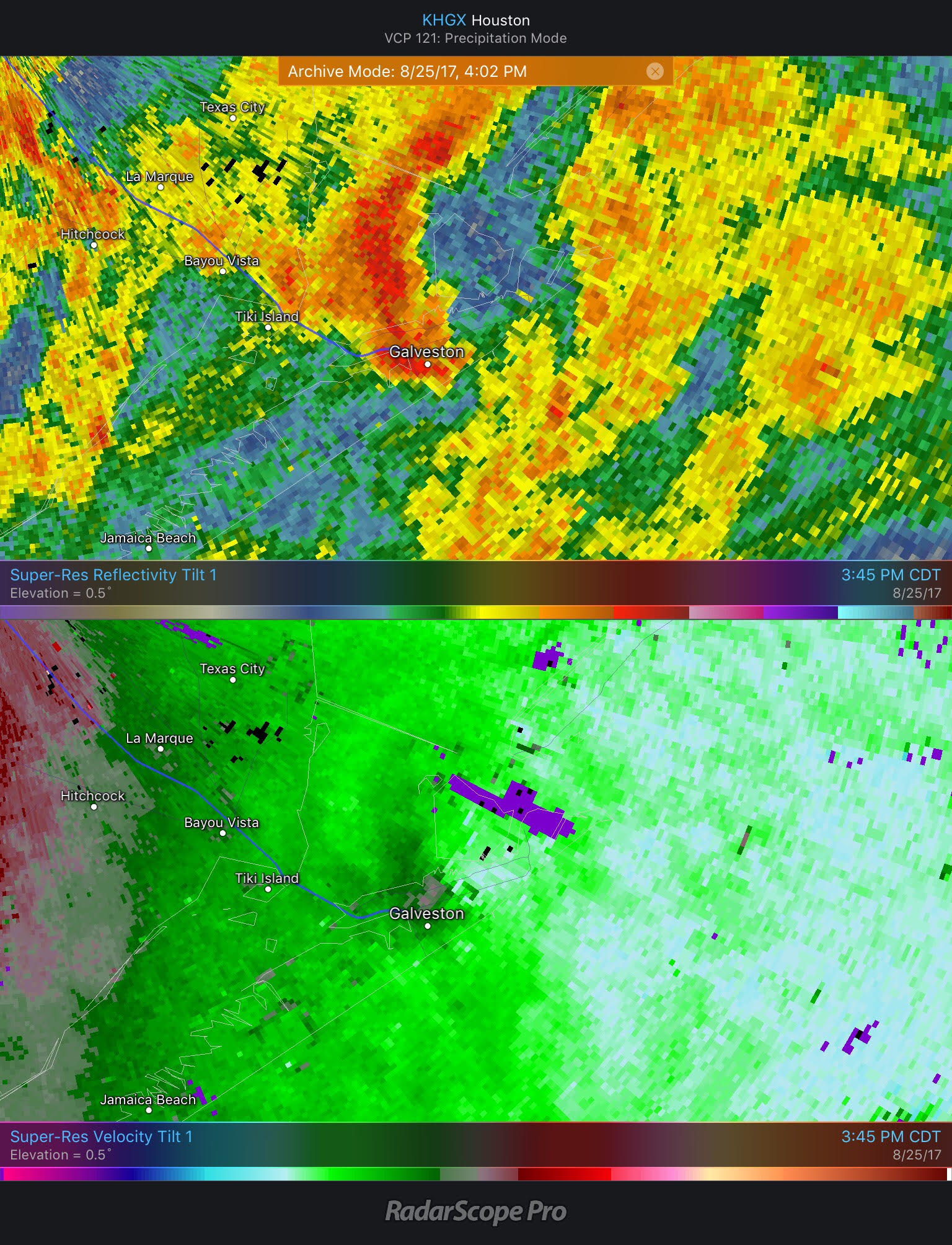
Right over Galveston, you can see on the bottom velocity panel, where there is a weak couplet. The signature disappeared quite quickly as the storm approached Bayou Vista, and ultimately it only looked like it could produce a tornado for about 15 minutes.
Next up, we’ll go to Brazoria County. This tornado occurred near Danbury around 9:45 PM during the Friday night that Harvey arrived. This one was originally listed as an EF-1, but it has been reduced to an EF-0 as of the September 14th update.
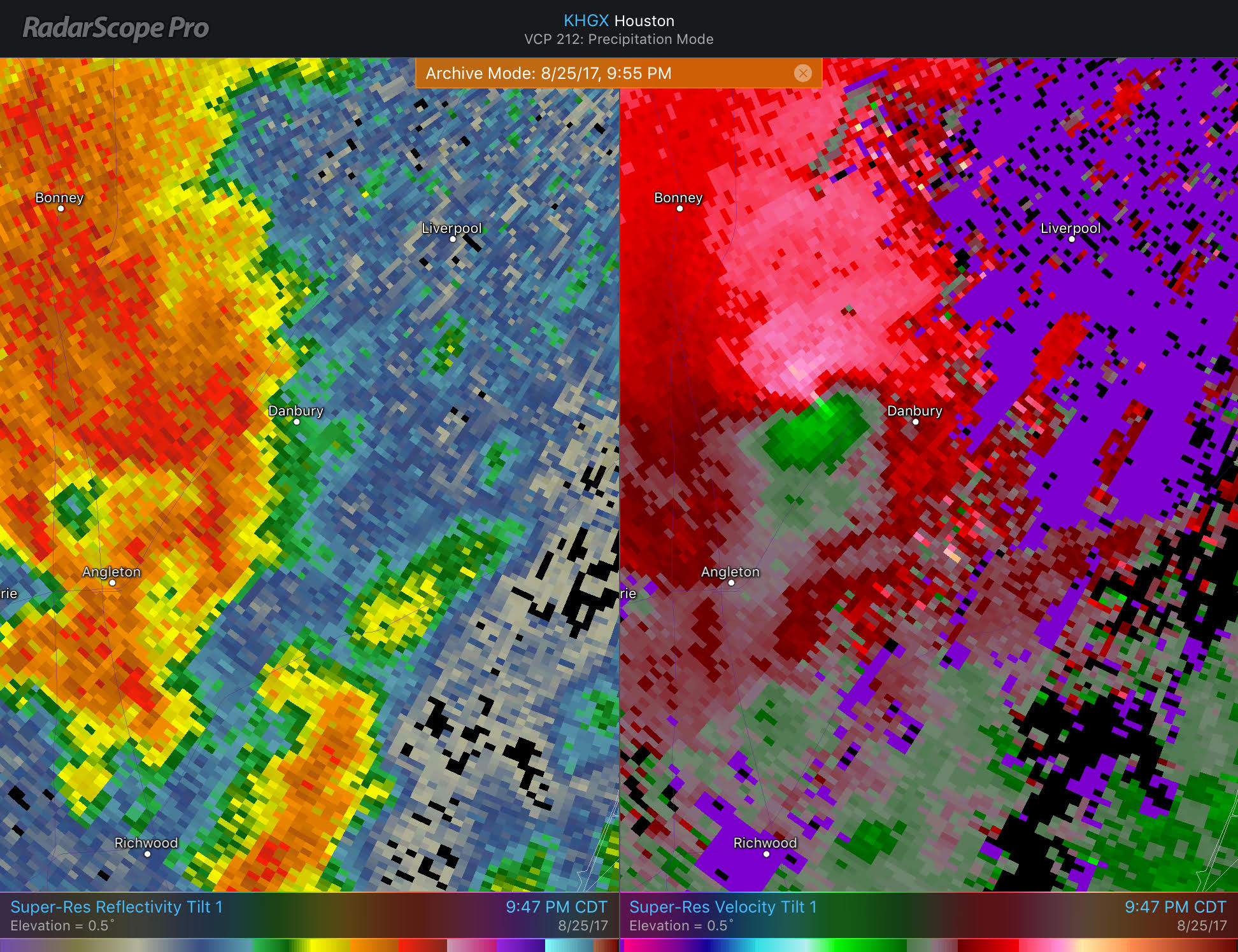
This tornado damaged a barn off County Road 207, crossed Highway 35, moved over an open field, knocked down some trees along County Road 45, and then lifted just east of 288 near Crocodile Encounter.
Sienna Plantation
Our next tornado was one of the more damaging ones of the outbreak. This is the one that rocked Sienna Plantation just before 1 AM on Saturday morning.
Strong winds––a possible tornado––heavily damaged some homes in Sienna Plantation overnight https://t.co/UjDGUrym1z #HurricaneHarvey pic.twitter.com/s9mQH6kerG
— Matt Keyser (@bymattkeyser) August 26, 2017
https://twitter.com/FotiABC13/status/901455935771734016
Debris left by tornado that touched down last night in Sienna Plantation, Missouri City pic.twitter.com/oJvjLRRX12
— Dylan Baddour (@DylanBaddour) August 26, 2017
We’ll walk through this one, as it seemed to last a bit. Here’s an animation you can reference.
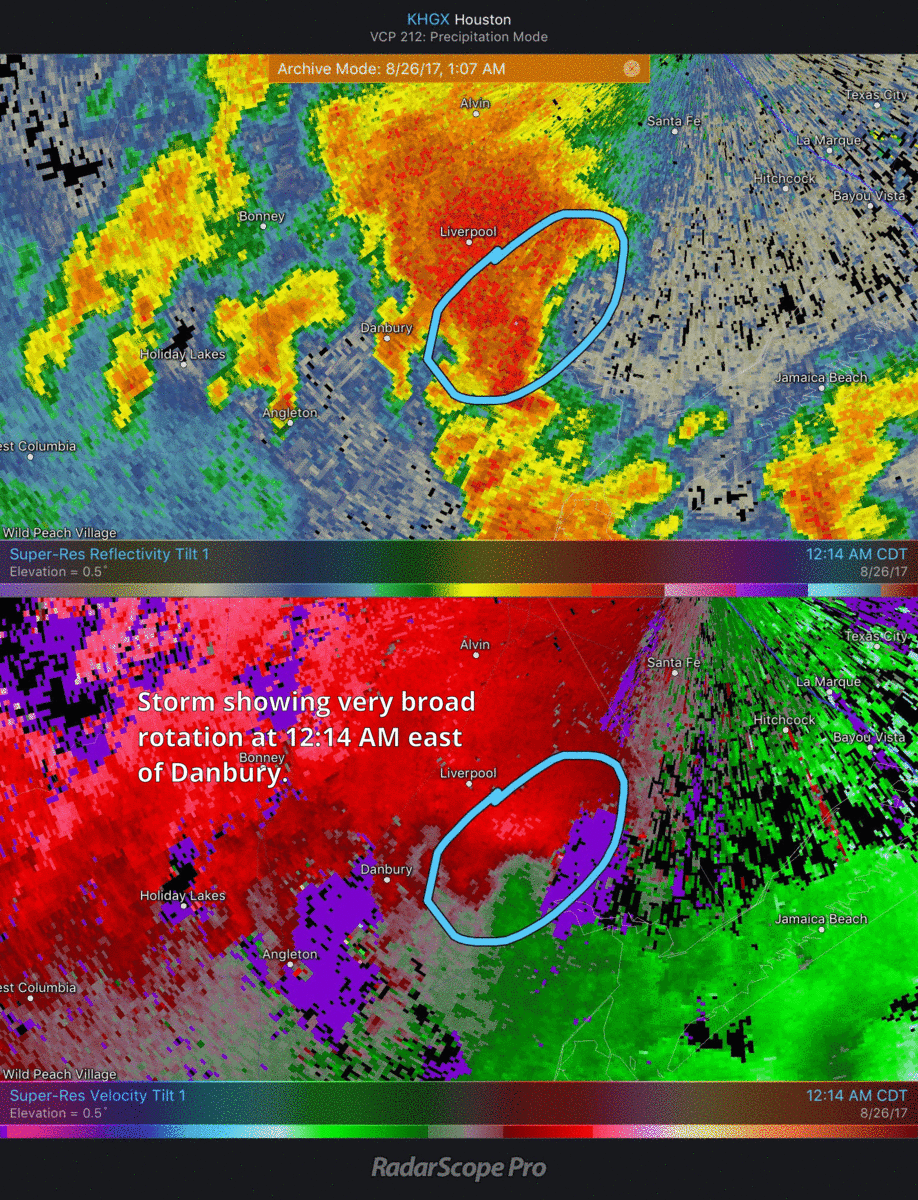
This storm was an interesting one. You can see how it evolved from broad rotation near Danbury to occasionally tightening up south of Alvin to a clear tornado around Sienna Plantation to a wind-producing storm just southwest of Missouri City.
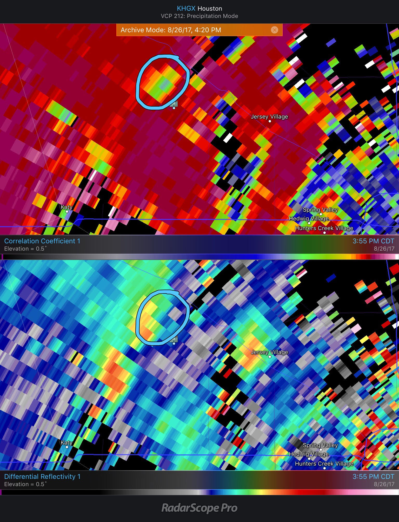
Going deep into the meteorological weeds here: You can also use the dual-pol function of the radar to essentially “confirm” the tornado. Co-located with the reflectivity “hook” and quasi-couplet in the velocity are low correlation coefficients (CC) and ZDR (differential reflectivity) values.
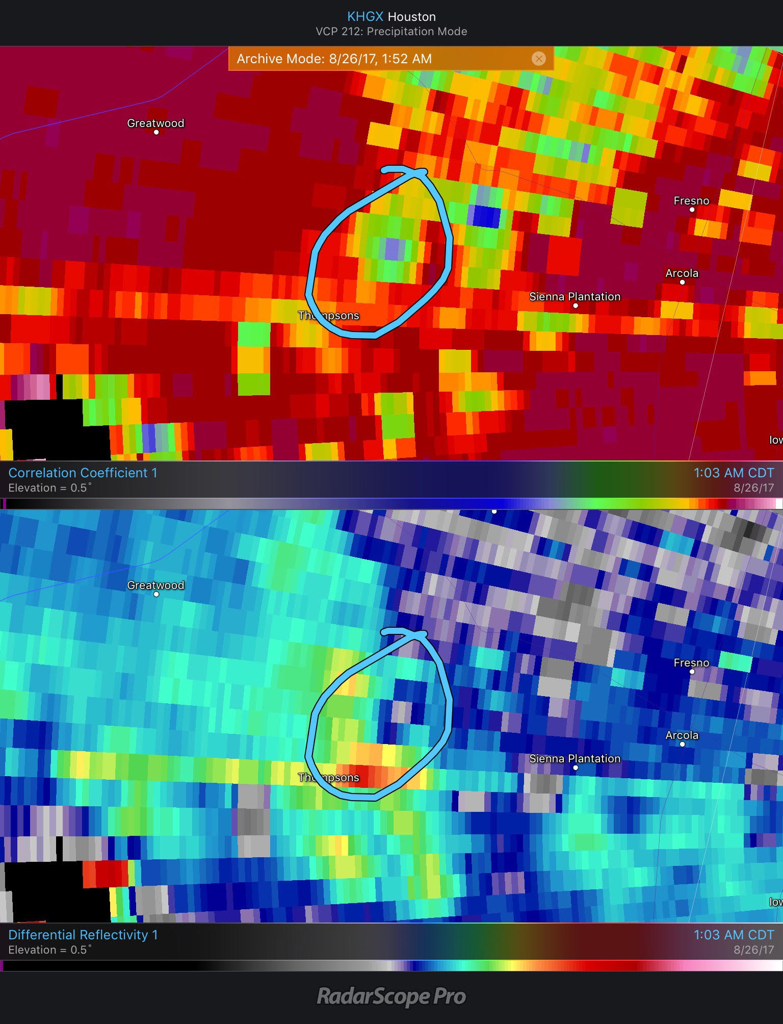
The combination of low CC, low ZDR, high reflectivity, and a velocity couplet or tornado signature indicates that the radar is picking up debris. Thus, you can essentially confirm a tornado on radar without actually visually seeing it. Want to see more examples of how to use all the tools of radar available to you to confirm tornadoes? My colleague, Ryan Hanrahan up in Connecticut does a really good job explaining various radar-confirmed tornadoes in his blog.
One other view: Here’s the Sienna Plantation tornado from the Hobby Airport Terminal Doppler Radar (TDWR).
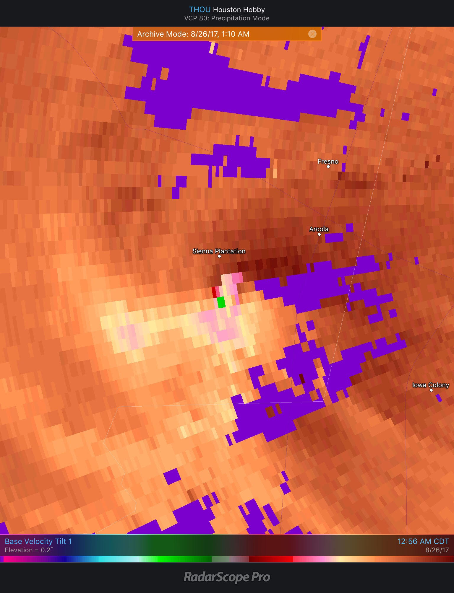
The color scheme is a little messy here (as it can occasionally be with TDWRs around here), but you can clearly see a likely tornado in there, moving right into Sienna Plantation. TDWR data covers a smaller geographic area, but it’s a bit higher resolution and updates every minute, which can certainly be advantageous.
Katy
Another EF-1 twister occurred in Katy before 5 AM on Saturday.
Damage to an RV and boat storage business in Houston suburb of Katy from suspected tornado. #Harvey pic.twitter.com/1FeEiQsSQW
— Juan Lozano (@juanlozano70) August 26, 2017
En la Interestatal 10 & FM 1463 Katy Area, consecuencias de lo que se presume fue un tornado esta madrugada #HuracánHarvey pic.twitter.com/5Z1ZkaOwd3
— Crishtbel Mora (@crishtbel_mora) August 26, 2017
Photos: Possible tornado damage in Katy area https://t.co/gBgjK5H1f0 #KHOU #HurricaneHarvey pic.twitter.com/HjiN5SrebZ
— KHOU 11 News Houston (@KHOU) August 26, 2017
This tornado hit near the intersection of I-10 and FM 1463 just south of Old Katy. This had some of the more dramatic damage footage of the tornadoes during Harvey, as it scored a direct hit on a boat storage and RV business on the south side of I-10. This is very close to the new Buc-ee’s that’s slated to open off I-10 west. The tornado continued across I-10 extending the damage path to the Pepperl facility behind the Buc-ee’s.
What was wild about the Katy tornado is that it formed within a band of thunderstorms that had multiple circulations. I’ll interject here for a moment. Communicating these short-fused tropical tornadoes is incredibly challenging. These usually form very subtly. They form quickly, and they dissipate quickly usually too (This tornado was on the ground for approximately 8 minutes according to NWS). So when forecasters at the National Weather Service have to warn on these, it becomes incredibly difficult to do.
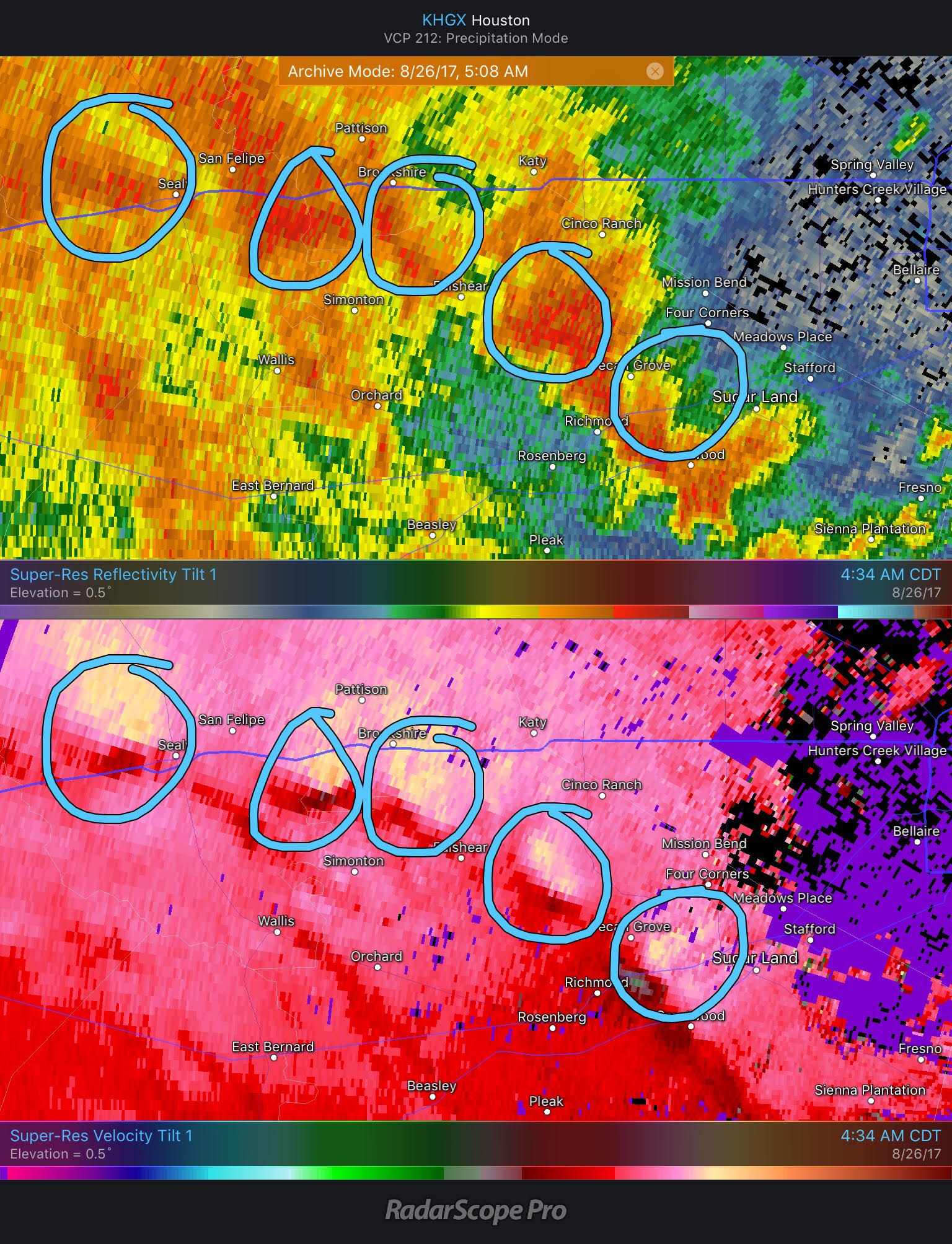
I mean, look at the image above and explain to me what you do with that? Any one of those could produce a 30 second to 15 minute long tornado. The one to the south probably looks the best at this point (and ultimately that would be the one to survive and produce the Katy tornado). But put yourself in their shoes for a second. This is truly a difficult to impossible challenge.
Anyway, the circulation near Richmond is the one that took over, and by the time it got to Katy, there’s almost no question this was producing a tornado, just before 5 AM.
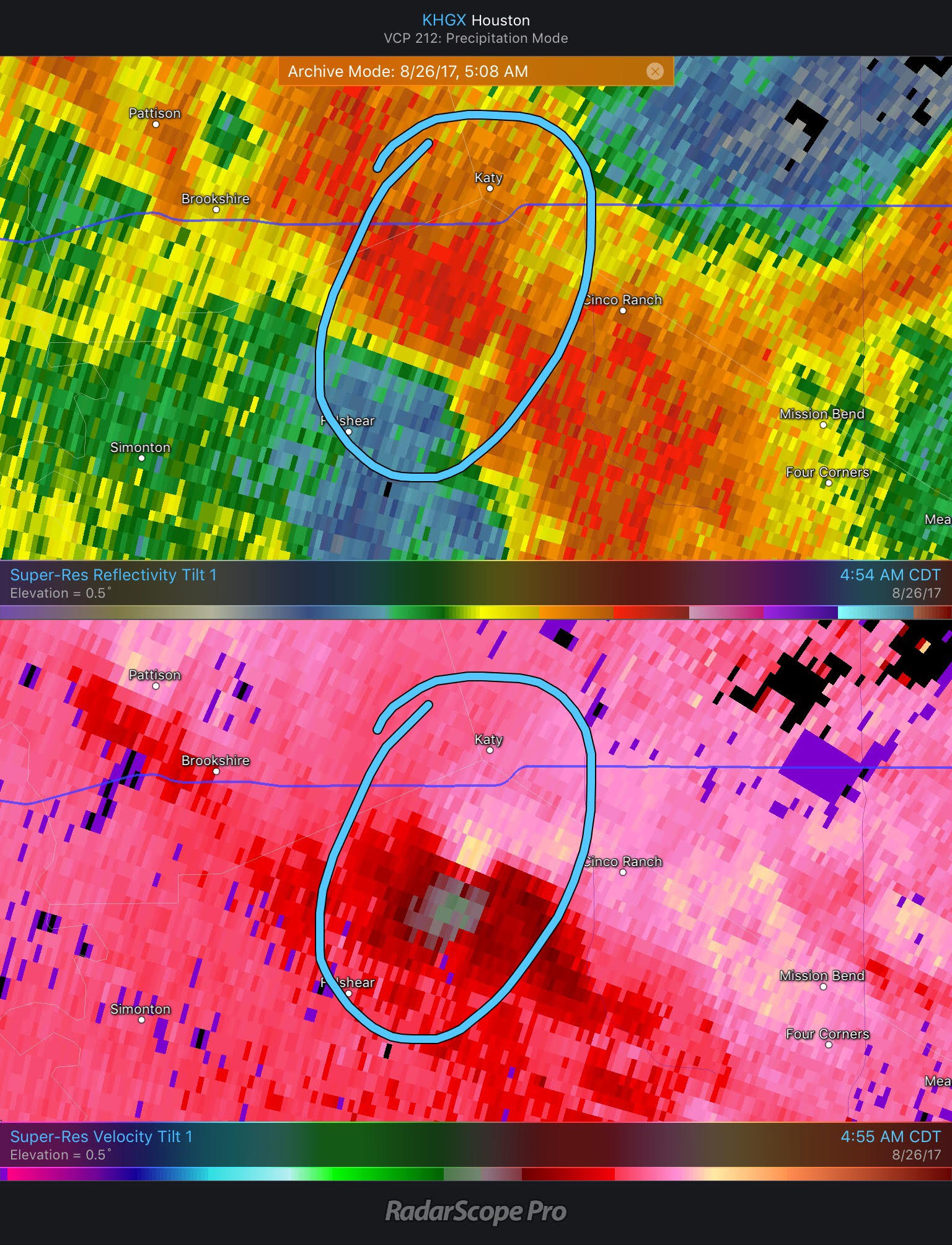
Also worth noting: There’s not a clearly defined “hook” in the reflectivity imagery here. Tornadoes are difficult sometimes.
Cypress Tornadoes
We had a bit of a break through the morning and afternoon, at least from stronger tornadoes. By evening, round two cranked up in a big way as our flooding event began to take shape.
Two tornadoes were reported in Northwest Harris County after 4 PM on Saturday. If the Katy tornadoes had the most eye-popping damage, then the Cypress one(s) produced the craziest video.
#cypress #tornado #hurricaneharvey tornado hit my neighborhood near barker cypress and tuckerton. Thankful that everyone is ok! pic.twitter.com/UXK35ocRpF
— Nicole (@honeybfly81) August 27, 2017
Harvey spawns another tornado in #Houston-area. This one is in #Cypress. Credit: Sandra Judge #HarveyStorm #Harvey #khou11 pic.twitter.com/Gg8JN7z0bB
— Tiffany Craig KHOU (@TiffanyKHOU) August 26, 2017
The dirty CYP😬 pic.twitter.com/7AFroZTll4
— Tactful (@tactful__) August 26, 2017
Surveillance video shows tornado tear through Cypress neighborhood @KPRC2 #Harvey #Harvey2017 pic.twitter.com/BVxeXtBZIB
— KPRC2 Rose-Ann Aragon (@KPRC2RoseAnn) August 27, 2017
We found another angle of the #HurricaneHarvey tornado that whipped through the @BerryCenter parking lot on Aug. 26, and it's pretty crazy. pic.twitter.com/hsi5JMmPIb
— Cypress-Fairbanks ISD (@CyFairISD) September 13, 2017
The first tornado was likely the one shown in the above pictures and videos. It began slowly forming probably near I-10 and Highway 6 around 3:30 PM. It traveled just west of due north and quickly became better defined by about 3:35-3:40 PM. By 3:45 there was almost certainly a tornado with this one. I’ve included a radar image around the time the videos from near the Berry Center (the building Emoji on the map below) were recorded.
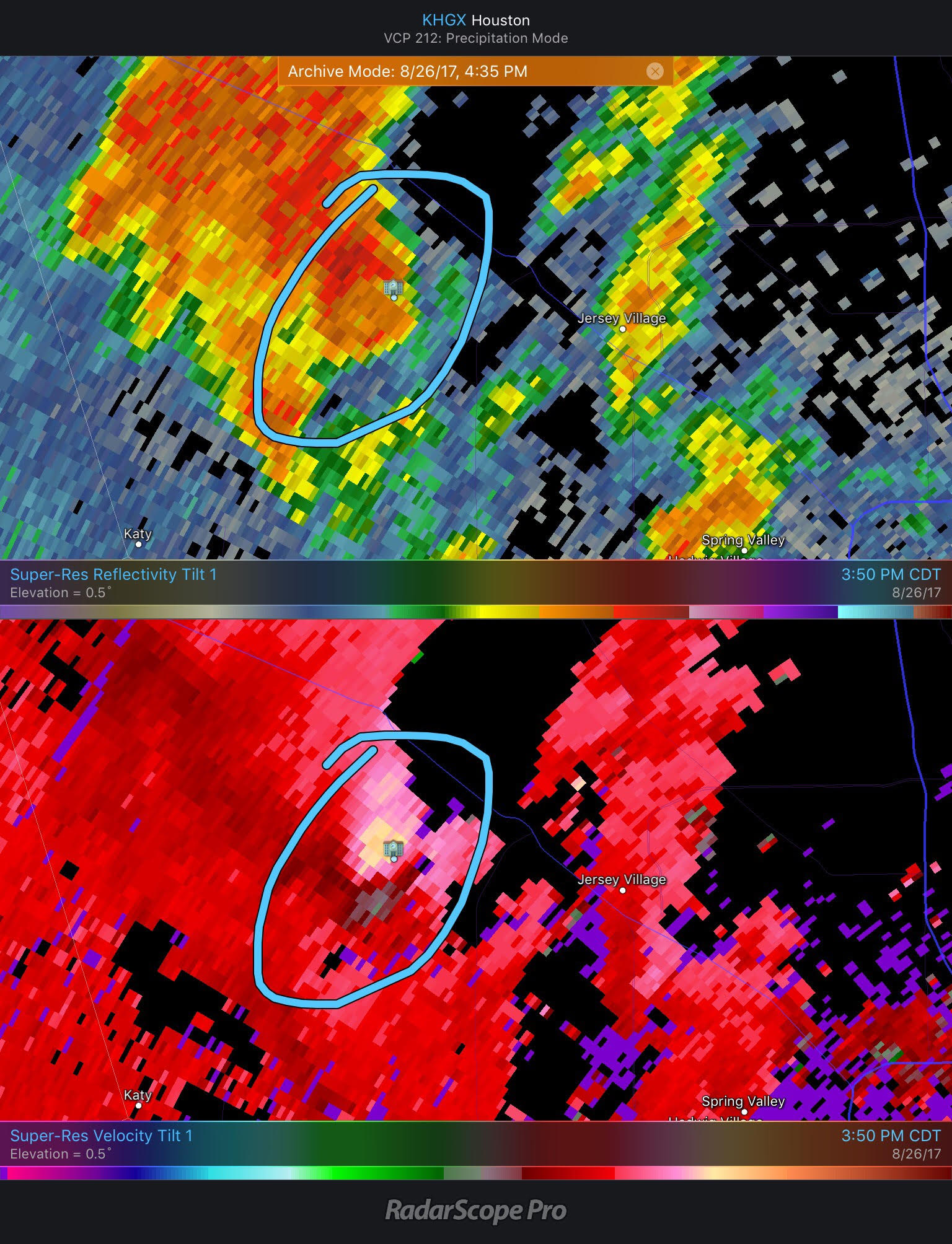
Using the dual-pol features as described earlier in the post, you can see we could probably confirm a tornado based on radar using correlation coefficients (top), but maybe not differential reflectivity.
That first tornado was pretty impressive. It was followed up by a slightly less impressive second tornado, but it occurred quickly in the wake of the first. Here’s a look at radar at 4:17 PM, only about 20 minutes after the first tornado.
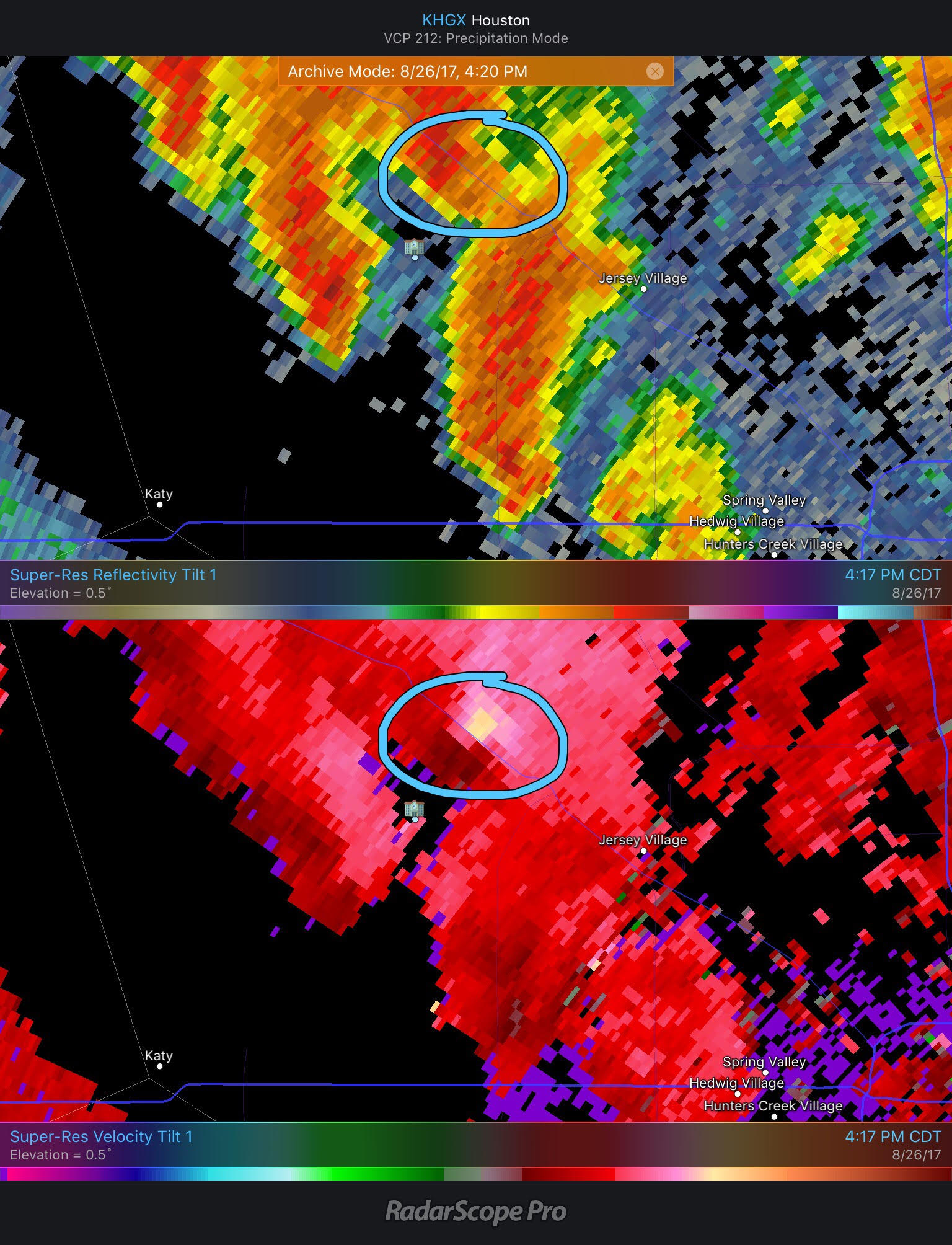
I don’t believe we have video or pictures of the second tornado. This one was shorter-fused than the first one (which had a radar signature for about 30 minutes). In this instance, there was really only a good signature on radar for about 10 to 15 minutes.
Either way, the video of the Cypress tornado will be the one that probably outlasts any other tornado memories from Harvey.
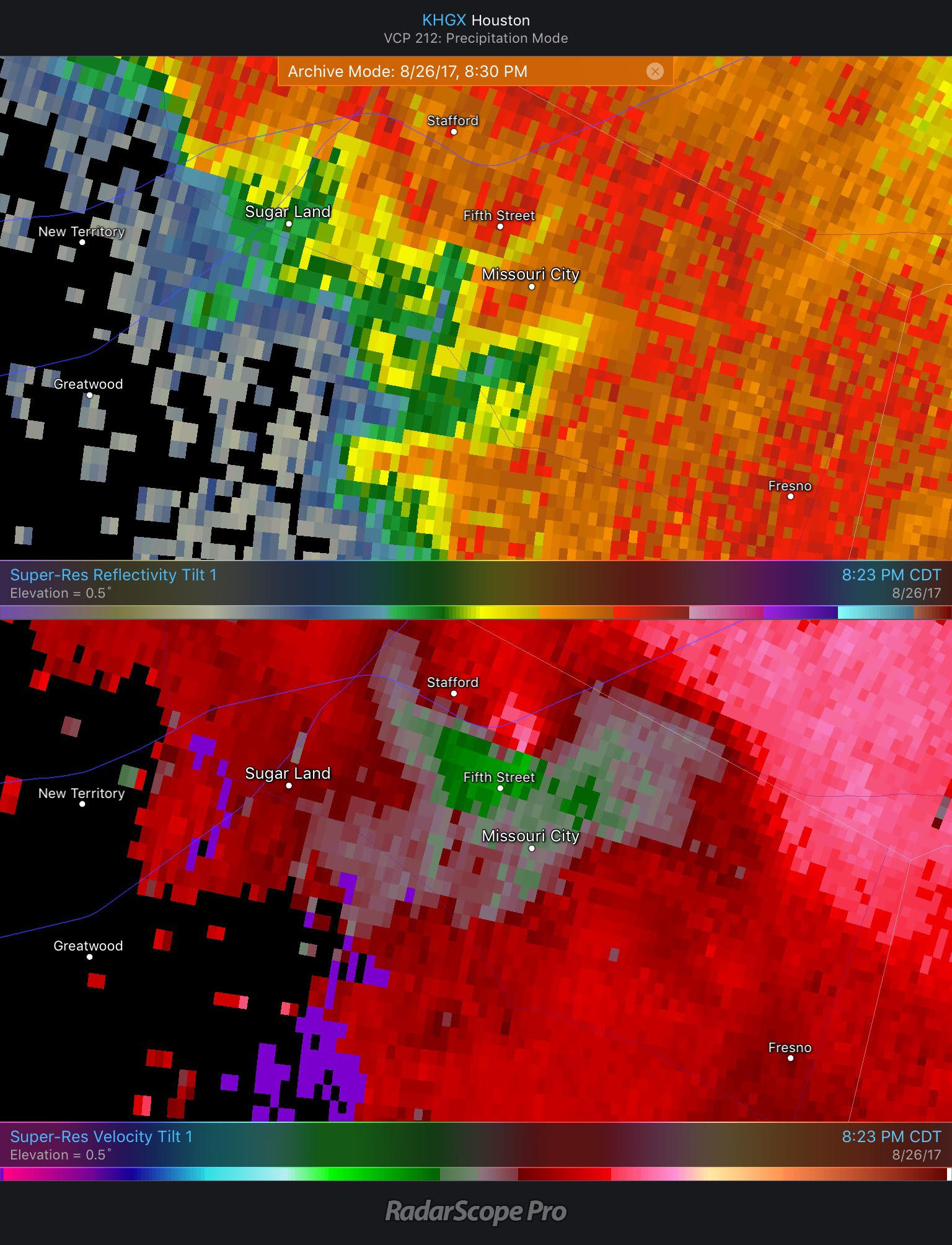
Stafford/Missouri City
Another EF-1 occurred in Fort Bend County and damaged 28 homes near Missouri City, along with numerous businesses. This one may have been the strongest tornado of Harvey here in the Houston area. The damage was fairly extensive.
Missouri City tornado damages shopping centers along Texas Parkway. "King Dollar" took a hit. pic.twitter.com/gputBbpqae
— Jacob Rascon (@KPRC2Jacob) August 27, 2017
Tornado hit in Missouri City, Texas. 🌪. #hurricaneHarvey #houstonflood #hurricaneharvery pic.twitter.com/BNOqNC2qU0
— JASON (@Jaysito777) August 27, 2017
Tornado damage in Stafford/Missouri City, Texas. I didn't venture further but 1 street is full of trees. #Harvey #SoOverHim #PleaseLeaveNow pic.twitter.com/9dz4WNvsxG
— Amanda (@TXgirl48) August 27, 2017
Here's some of the pic from the Missouri city , tornado pic.twitter.com/KNzsC78A8B
— JOSE (@JOSEGARCIAZ06) August 27, 2017
Around 8:05 PM, if you look at radar, you see a very broad area of rotation showing up north of Sienna Plantation.
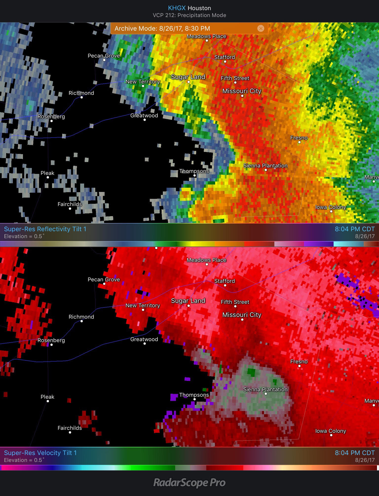
About 10 minutes later, you can see the rotation slowly tightening up near Missouri City.
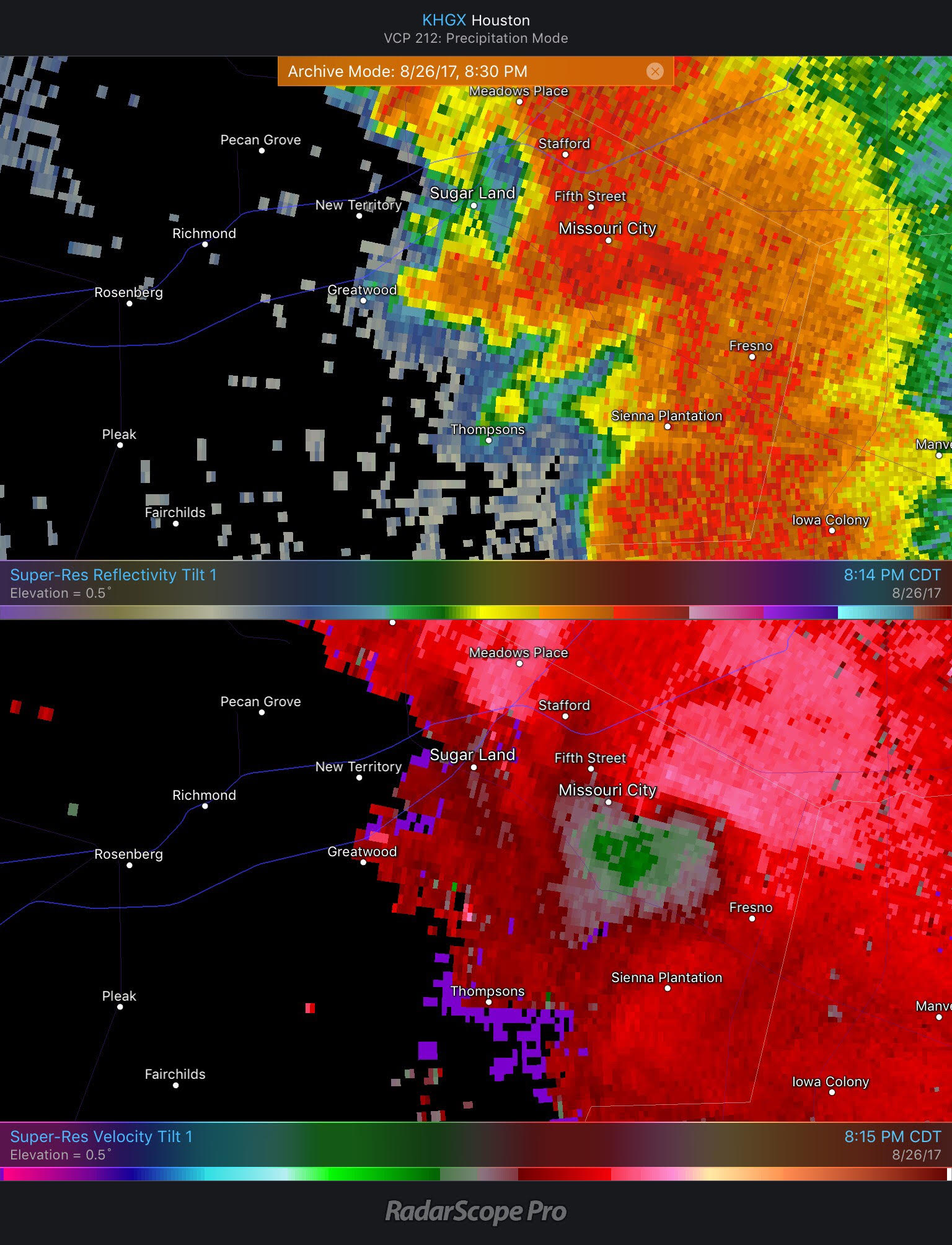
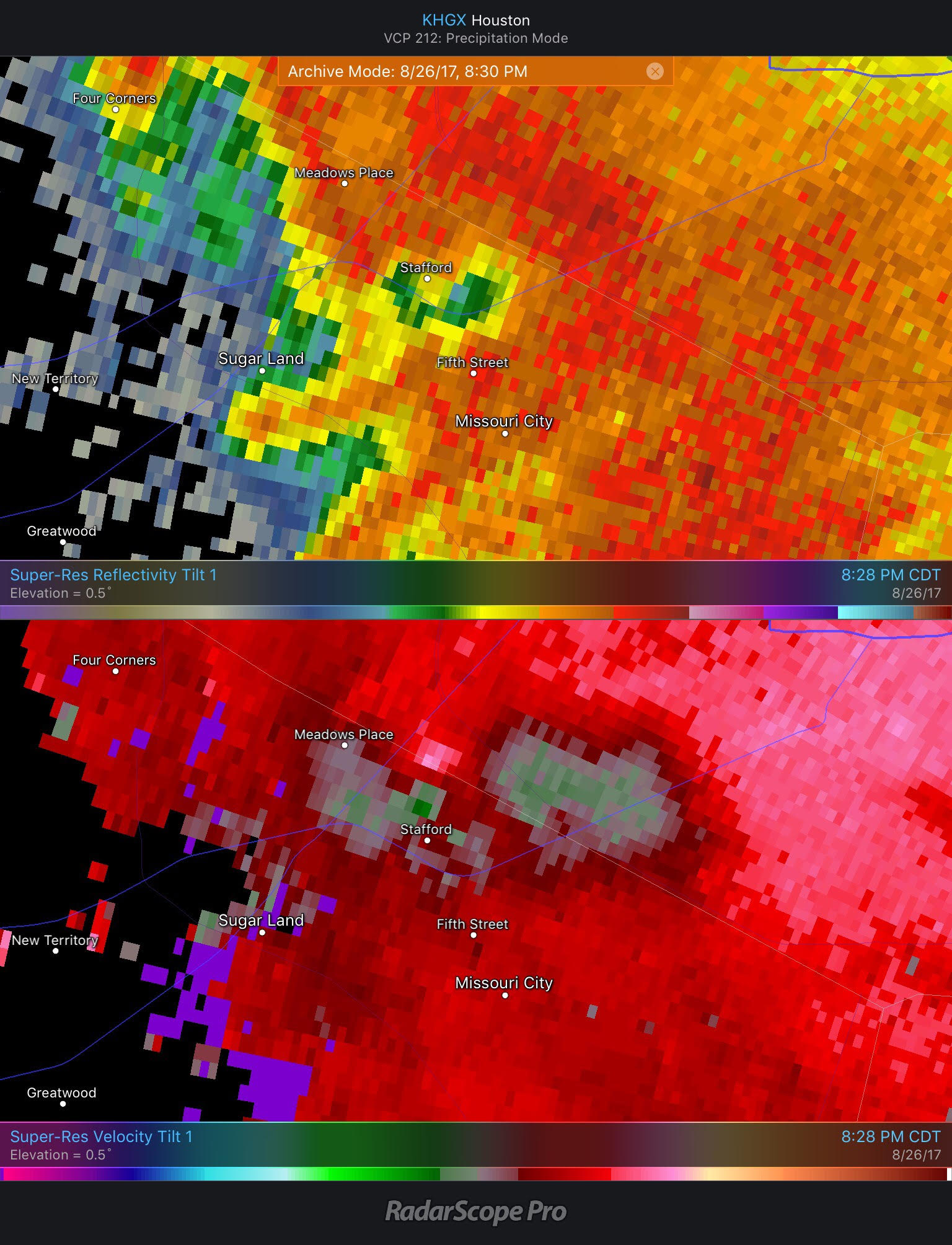
Just beyond this point is likely when the Wingstop on FM 2234/Texas Parkway in the video above was hit by the tornado.
We can fast forward another eight minutes and see the tornado likely still on the ground, doing damage just south of Alt-Highway 90 in Missouri City.
In addition to the traditional radar, you can again use the dual pol tools to see that this is likely also a radar confirmed tornado.
Looking back at #Harvey tornadoes. Tornado Damage Signature for MoCity EF1. Vel couplet UR,low corr coeff LL, low ZDR LR->tumbling debris pic.twitter.com/G8AaCa8mld
— Dan Reilly (@DReillyWx) September 12, 2017
The bottom left panel on the above image shows it best, with the little green/yellow blob showing up near Missouri City. If no one had been there, meteorologists would still be able to confirm the tornado.
By about 8:30, the tornado is dissipating as it approaches the Southwest Freeway, if it hasn’t already lifted.
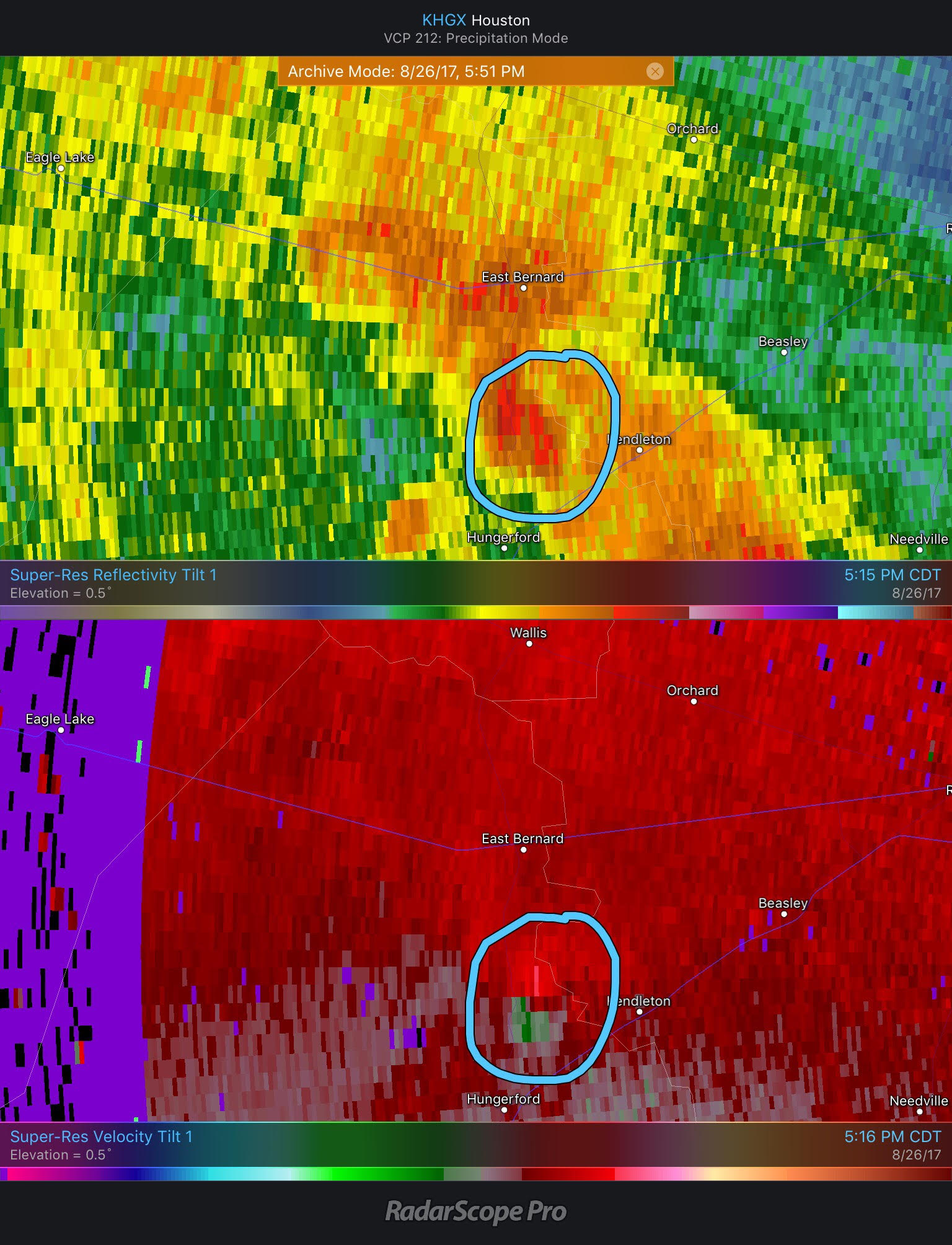
East Bernard
The last of our confirmed EF-1 tornadoes occurred around 5:30 PM Saturday near the Wharton and Fort Bend County lines west of Houston. According to the NWS post-Harvey report, the tornado started as an EF-0 near Downtown East Bernard, then moved across Alt-Highway 90, strengthened into an EF-1, snapped some trees and damaged the brick facade of a home.
The photos below are from August 27th, so I’m not sure if this is from *this* particular tornado or not, but they are from East Bernard.
@Fox26Houston Tornado damage in East Bernard Tx. Hit at 1:30am pic.twitter.com/M5WGEJgMj4
— Lori Middleton (@Footballmum77) August 27, 2017
@Fox26Houston More tornado damage East Bernard Tx pic.twitter.com/nYpBoy6FLy
— Lori Middleton (@Footballmum77) August 27, 2017
@Fox26Houston More tornado damage East Bernard Tx pic.twitter.com/dvMxQcOgcl
— Lori Middleton (@Footballmum77) August 27, 2017
Anyway, on radar, this tornado formed just after 5 PM on Saturday. It showed a decent radar signature just west of Kendleton, along Highway 60 in Wharton County.
Around 10 minutes later, you can see the tornado has moved north into East Bernard. The signature is actually a little less impressive here, but this is where it did some damage.
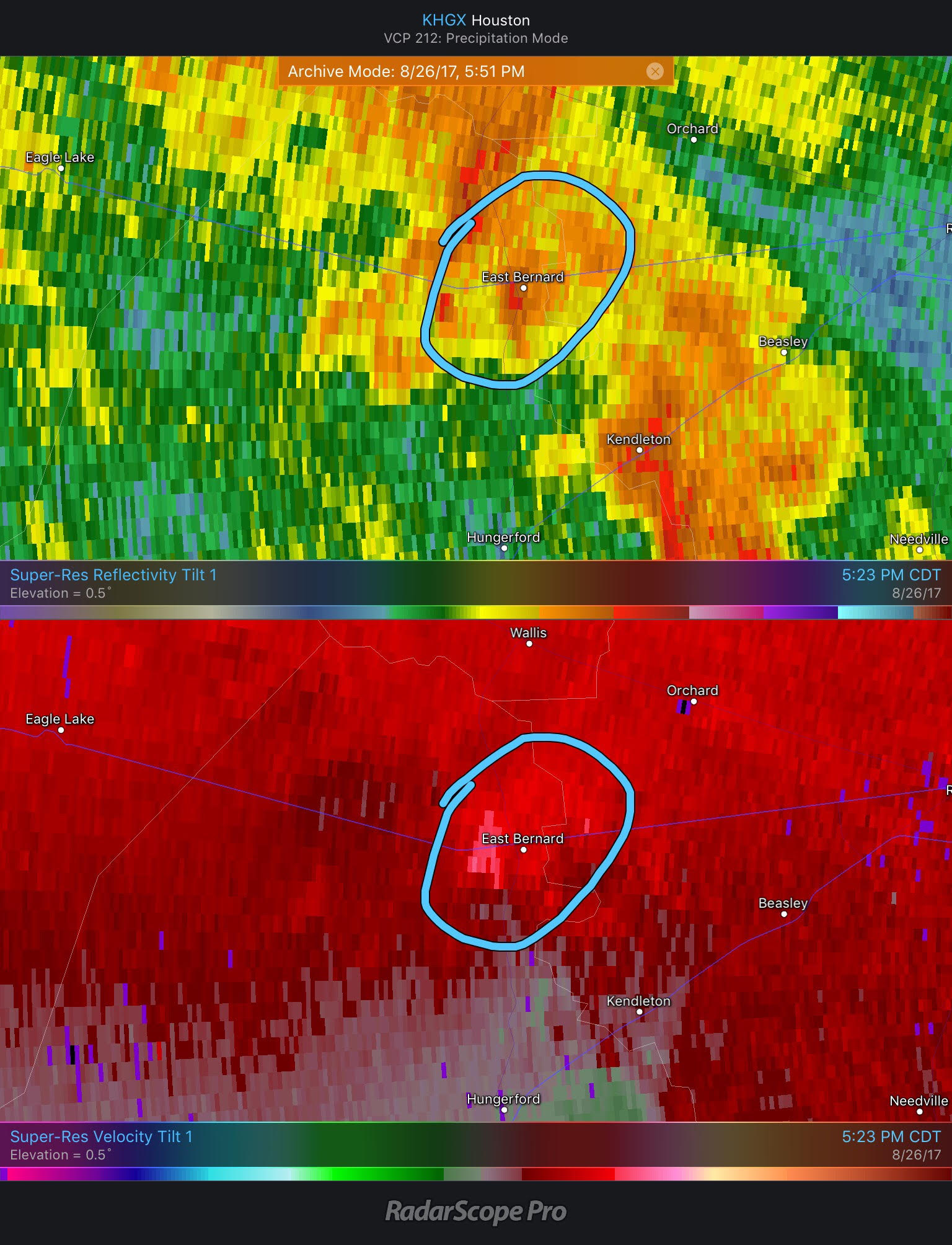
Around five or ten minutes after this, the signature dissipated, and the tornado had certainly lifted. Either way, just another short-lived, tricky tornado to peg down.
Final comments
I know a lot of people were shaken and, at times, frustrated with the number of warnings that kept popping off on their cell phones throughout the event. If there’s one thing I hope you can take away from this post, it’s that warning on tornadoes is very difficult in a normal situation. In a situation like this, where storms are racing and producing very quick, very short-lived tornadoes (that can cause serious damage), the folks at the National Weather Service, who are obligated to warn for these things have an overwhelmingly difficult job to do.
If I could present one criticism it would be this: I would like to see a situation where weather alerts on your cell phone can be broken down by warning type. For example, while the flash flood warnings were critical (and well handled) in this event, a lot of you knew it was flooding, and perhaps your nerves would have been less rattled if your phone only went off for tornado warnings. It’s a very difficult problem for which there is no real good solution. But I think everyone should be able to have some flexibility in what they’re being warned about.
An argument I’ve heard from some in the meteorology community about over-warning on tornadoes is that we should “only warn for the bigger ones” in situations like this. To that, I’d say, look at photos of the damage in Missouri City or Sienna Plantation and videos of the Cypress tornadoes. These were EF-1 tornadoes, or “weak” tornadoes. But there was enough damage in a few of those instances to injure or kill someone. So I do not think that’s the answer here. At the same time, we really need to understand that some people will begin to tune warnings out if they get too many and nothing happens to them. So trying to find a balance is important. I just don’t know exactly what that balance is. Maybe the reality is just that systems like Harvey are unique. Perhaps it’s up to everyone to be understanding through the event and realize that the warnings aren’t being issued to annoy us but to protect us. It’s a tough pill to swallow, but then again, Harvey was a really tough storm to go through. There aren’t concrete answers here, but there are topics that merit further conversation.
You’ve outdone yourself on this one. Excellent article.
Here in clear lake we had 40+ mph winds whip us around 4am on august 27. Any report of a tornado or was it just a strong gust?
I agree with this and wonder as well. We live near the intersection of Space Center BLvd and Genoa-Redbluff and were awoken at 4am by extremely high winds causing the house to pop (or settle). The noise was incredible and I ran upstairs to grab my sleeping daughter only to reach her and have it end at that moment. We were told there was damage to a construction area just up the street as well as fences down in this area. I too wonder if something could be confirmed at 4am 8/27.
There was a tornado warning in League City by radar, “moving north at 55 MPH” just before 4 AM Aug 27. A few minutes later is when that wind event occurred on Space Center (we were near Space Center at Bay Area Blvd). It blew a transformer near us and then broke a tree in half in Bay Oaks, so I think it was indeed a small tornado.
I was getting tornado WATCH warnings, tornado WARNINGS, Flood WATCH, Flood WARNING, and catastrophic flood WARNINGS all at the same time.
At one point I was having to scroll through all my warnings to find the tornado warning that had just alerted and see if it was close enough for me to take cover. Maybe in that extreme of an event we remove the watches and only alert on the warnings? I belive at one point I had 15+ active alerts on my phone.
It would also be helpful if they could re-direct a warning to those directly in the path. Often when i get these warnings, it will be an area no where near me because Houston/Harris county is so huge.
They were usually spot on for me – I was usually really close to or directly inside the warning area. I got five on Saturday night. The KPRC guys did a good job I thought of showing the velocities and explaining where they thought the tornados actually were. There was a delay between when the phone would go off, when the online apps would update, and when Frank would start talking about it. I wish the NWS would put a picture of the warning box with the text. The closest one struck about a mile from my house closer to Cyprus. I will say I got my hidey-hole ready but I never went into it.
I guess it should harder for us because we are in clear lake, so Harris county technically. But we are on the outskirts. I have had to change my warnings to Pasadena and webster to get warnings of any value.
The tornadoes! Warnings coming every few minutes all through the night!!! My husband and I got ZERO sleep that Friday night…. and for absolutely NO reason! We live in the Spring area. The government issued tornado alerts that kept going off on our phones were for “Harris County.” I mean, seriously! How many miles does Harris county cover?? Close to 700? Why do I need to be warned about a tornado that is nowhere near me and has no chance of coming anywhere close to me???
Space City Weather guys, if y’all can come up with a better, more targeted way to issue weather alerts, and make it available to the public (make an app, or sell it to the government weather alert people, or whatever), I will sing your praises to everyone I know, and I’ll donate to whatever cause you deem worthy, and…. and…. um…. well, other stuff….!
Seriously…. it got to where we just shut off the alerts and hoped that no tornadoes would end up coming our way! We just couldn’t take it anymore!!!
We lived in tornado alley for years. When there was a tornado that had the potential to affect us, we were alerted…. but only if it had the potential to actually affect us. The tornadoes that had no chance of coming near us, we found out about on the evening news. We ought to have a system like that in place here!
I know, there usually isn’t a need for that here…. BUT on rare occasions, it does happen. Please, please, please, please, PLEASE look into it!!!!!!???!!
I’m not certain if this is the case, but I believe these alerts are supposed to be targeted to your specific geolocation, not the entire county. So it was just that that many possible tornadoes were occurring near you. There were over 150 warnings issued during Harvey, so you were bound to be under quite a few unfortunately. It’s a tough situation.
We live in Cypress but were also getting all the tornado warnings for Harris county and even for Fort Bend, Brazoria, etc. It was nonstop alarm warnings going off. When they are repeatedly for other areas it is easy to begin to ignore them. We were having to look up where they were for as well since it would just say county information too. Also, my parents house was hit by the Sienna Plantation tornado. That was the only time they said they didn’t get a tornado warning alert. They woke up to the noise of the tornado. My brother was awake watching tv and said he never received one either, and then the windows were breaking and he ran to wake up my parents and they ran to the bathroom. Was an emergency alert sent out for that one before it hit?
There was a warning issued for the Sienna Plantation tornado, but it looks like they only had maybe a couple minutes to act before it hit. It may have been a later than ideal warning. Happens sometimes unfortunately.
My Android phone seems to be much more selective about alerting. None of the warnings directly covered my neighborhood, and my phone was pretty much silent. (Eric, in Android I can turn off alerts by type, FYI.)
The weather radio, however, was going off all the time. The digital data in the garbled sounds at the beginning of the alert contain county codes, but the EAS system doesn’t get much more granular than that. So my radio ignores alerts that don’t include Harris Co., but as was said, that’s a lot of square miles.
Remember there’s a variable delay between NWS issuing the warning and all the systems that need to receive and process it. Your basic weather radio likely doesn’t have GPS so with the current design more granularity at an automated level isn’t useful, in practice, by most. Maybe with a replacement or evolution of EAS some day.
Be careful what you wish for, though. If they make the alerts too specific and the storm suddenly changes, the only way to update everyone is by… sending even more alerts with new data.
I think it might be Android that is the selective one. I live in Cypress and I only got the alerts for the ones that affected me, including the one with the videos which was very close by. I didn’t get any alerts for the ones that were going off in other areas of Harris County.
We were at a restaurant Friday night and I kept hearing all of these tones, nonstop throughout the hour, that I thought were timers going off in the kitchen. Duh…my wife told me they were the cell phone severe weather alarms of patrons, for problems nowhere near us. They were all being ignored, as were the nonstop alarms on our cable TV during the coming days. NWS must find a way to pinpoint the alarms to areas that are actually in danger, or else they will be known as the boy who cried wolf.
This highly instructional and detailed account of the tornadoes during Harvey are a bit difficult to appreciate because all videos would not play “the media cannot be played” Are those all iphone videos and will not play on a windows based computer? In any case the explanations and “still” images are obviously the most instructive ones, but I wonder why I cannot play the videos.
Videos are amazing!! You all did an incredible job…. before, during, and after!!! Absolutely INCREDIBLE!!
Amen!
I’m 60 years old and have never understood tornadoes better than after reading this article. So focused and down to earth. Although Harvey brought some bad things into the lives of Houston area residents-the good things far out-weighed the bad. Finding SpaceCity Weather was one of the best!
The flood warnings were the ones affecting us. Almost a “captain Obvious” type of situation and not much we could do about them. They seemed to expire and re-warn over and over. The Tornado warnings made more sense because you could do something about those; away from windows, interior room etc.
Thanks for this summary!
Are the warnings able to be directed to cell phones in a certain area? I live near Greenway Plaza and I got a number of tornado warnings even though they were geographically irrelevant. I think the future of warnings is to be able to target those in just a small area where the event is most likely to occur or will eventually move to.
I thought the current method took care of that, but I guess maybe not? Maybe it depends on phone? I’m not sure. I 100% agree with you. The people that need to know should know…others, not so much.
This system was a nightmare. The anxiety from all of these constant tornado warnings was unreal. Our house is on the westside near Greenhouse. At one point on the “busy night”, we were under 5 or 6 different tornado warnings for almost 3 hours straight. At least 3 of them overlapping at once. I’ve never seen it and not sure that has ever happened before. If it never happens again, it will be too soon.
As an event like this comes around so few times it would probably not be productive to make wholesale changes to the system. Perhaps we should be allowed to edit our own alerts to only allow what we deem important. If we edit out an alert that then affects us so be it.
At our house we turned off all devices except one, which was monitored by one of us throughout the night, so that the kids could sleep without the constant alarms waking and scaring them.
Sorry, but this may come off as a rant..I think the weather alarm warning systems are just fine.. Going thru an event like Hurricane Harvey was extremely scary and dangerous for many people..I decided to heed the voluntary evacuation orders for my city, partly because I feared that my nerves would be frayed to the breaking point..I decided to save my strength for what I might find upon returning home..I didn’t want to face the possibility of having to be rescued from my house, in the middle of the storm, with no choice on where to find safe shelter………Riding out a disaster is highly unpleasant..I think many of the ADULT minded people who stayed were prepared to be in Hell for a while..Fully knowing that government and media officials were obligated to give them information” as is” in real time without softening the experience..
That Saturday night/ Sunday morning was one of my most stressful nights ever. The constant alarms were awful, even though I don’t dispute that they were necessary. I got stranded away from my house during Allison. I elected to ride out Harvey. It’s a pick your poison scenario- either way is very stressful. I was cut off by flooded roads for about 5 days with Harvey, but at least it was in a dry house with functioning utilities and plenty of supplies. I was prepared for the possibility of getting flooded and being stranded for a while, but fortunately that did not happen.
Awesome analysis Eric. You and Matt are Houston heroes too.
Sorry Matt, it’s you I should credit.
I echo the sentiments about the warnings. I live in the hard hit Southbelt area, and was getting tornado warnings for places all over Harris, Fort Bend, Brazoria counties. Even in the last week I have been getting flood warnings for the Resevoirs in west Harris county. I know the alerts are *supposed* to be geolcated, but I had to scroll through a lot of warning until I found the locations likely to be affected. I wish the goelocation function would be better.
My phone DOES break alerts into tiers. I only get “extreme” warnings, which includes tornadoes. I turned off severe alerts like flash flood warnings or any watches or Amber alerts. That’s with a Samsung Galaxy S6 Emergency Alerts app. So, it’s possible to do, but may depend on phone manufacturer to implement.
I was getting tornado warning from all over and in addition to that tons of flood and flash flood warnings. It was to the point it was hard to find the tornado warning to see where it was. I think only one was for my area and another ended one street from me.
I would have been happy if I could just turn off the flood and flash flood warnings temporarily. I knew we were flooding and I wasn’t going anywhere. I didn’t need to be continually reminded of that.
My roommate finally fell asleep in her closet and some how I accidentally (possibly in my sleep) turned my phone to do not disturb which is how I got to sleep that night.
Amazing breakdown of the tornados-THANK YOU. The tornado situation is so interesting since most Houston Homes have limited areas of protection from tornados. previously living in areas that have EF-2/3 tornados where the homes have more protection makes me very diligent about Tornado warnings here. The phone warnings did not narrow down the location enough-when used in conjunction with local news or weather channel(who immediately showed tornado radar) which narrowed down the risk area-it was very useful and found myself so thankful that it is possible to narrow down and communicate today. it was not so many yrs ago that we would have no idea at all there was a nearby tornado. I am sure the NWS will continue to refine and advance the technology to greater precision. Fact that there were that many hurricanes and not deaths due to them(assuming here) is amazing. Rather have the warnings than surprise of the sound
oops sorry for that typo at the end should say “many tornados” not hurricanes.
I’d be curious to know what safety precautions we should take for these lower strength tornadoes. Is it really necessary to be in the smallest innermost room? Or would just being away from outside walls/windows be ok? We have small children and having to wake them in the night to go to our tiny laundry room makes for a rough night and following day. And even during the day being confined there with them when they can’t understand the situation is hard. So I’m wondering if there are different levels of safety precautions for the varying strength of storms. And it would be nice if we could be notified of the potential strength of the storm too if that is able to be know ahead of time by the radars.
Thank you for such an instructive analysis of the tornadoes. They’re my biggest weather fear. I live in Sugar Land and spent several hours each night dealing with tornado warnings. I found the KPRC and KTRK coverage that included the neighborhood level descriptions and time estimates extremely helpful.
The emergency alert system on my phone was spotty and delayed; however, I downloaded a Red Cross app that did an excellent job of alerting me. It included a link to the radar image that I could zoom in and see if I was actually in the box or not.
It was a lot of warnings but I’d prefer to be warned and make my own decision about taking cover. I’m thankful for the NWS being so proactive and doing their best to inform the public in difficult circumstances.
Thanks so much for your clear and well-written analysis as always.
I live in West Houston, and am not familiar with many of the locations described in this post, so as I read I had a hard time getting a good mental picture of the overview of what this looked like for the city and outlying areas. If you find yourself with some time and the inclination 😉 , I would love it if you created a map that shows the major roads and the tornado touchdowns with date and time.
On Saturday the 26th I used drivetexas.org to identify a clear (non-flooded) route, and evacuated from West Houston (BW8 and I10). I realize there is no predictive value for future situations given that each storm is different, but with the ability to look back now, I’m curious which of the routes I considered actually had more tornado activity/worse driving conditions.
I left at 2:20pm, going East on I10 to 59 and then North on 59 to Henderson, Texas, arriving at 6:20pm. Once on 59 I stopped twice to take shelter due to cell phone tornado notifications (did not observe any conditions), and was forced to pull over two other times due to the intensity of the rain creating zero visibility. My alternate destination was Austin, going west on I10, which theoretically would have meant less time out on the road, but at the time felt like a more dangerous route due to flooding risks.
On the note about breaking down the warnings into separate types of warnings, I found that the tornado app by Red Cross would offer me only tornado warnings, which is exactly what I wanted. Once I switched to that, I had a much more restful night’s sleep.
What’s the strongest tornado ever to hit the Houston area? Is there a recommended web site to see active base velocity radar in live time?
Not sure if this is “the strongest,” but I grew up in Channelview (I was a middle schooler at the time), and I am so thankful we were not home that Saturday afternoon. The devastation we saw throughout our neighborhood the morning after remains the worst natural disaster-related damage I can remember having ever seen in person. We wound up with four trees on our house and every “storm” window on the front but two broken out (and the ones that remained were bowed inward), but that was nothing compared to the street just to the east of ours, where the tornado literally wiped concrete foundations clean. A close friend who was in one of the homes on a street that saw massive devastation had nightmares for months — if not years — later.
https://spacecityweather.com/november-1992-tornado-outbreak/
I was feeling lots of anxiety because of the warningsgoing off so often. I live in Midtown/Montrose, how likely is it that a tornado would hit the downtown area? Has it ever happened?
This was the first time I heard the tornado warnings issued for this area and I was almost panicked since I live upstairs and there’s really nowhere to go if one actually hit.
Back in November of 1992, there was a tornado fairly close to downtown. Believe it went from about Hermann Park through the Third Ward into the East End. Another tornado in that outbreak popped up in EaDo I think. It’s entirely possible (downtowns don’t offer protection from tornadoes…they’ve hit in Los Angeles, Nashville, Miami, and Salt Lake City’s downtowns before). But whether or not it’s actually happened directly, I am not sure!
The problem with the tornado warnings wasn’t that they were there; it was that they were going off *twice* for the same alert, within seconds of each other, on both of our phones, for a total of four alerts for one warning. One per phone per alert would have been fine, but it felt as if someone at the NWS had misclicked a box in the alert database. :-/
Really fascinating article, however, and thank you for the in-depth detail.
With my phone, I was fortunate to be able to select which alarms I would receive, by area..Picking the Pasadena/Deer Park/La Porte area meant that I didn’t have to hear ALL of the alarms for the Spring area or Galveston..I also had our city’s READY LA PORTE installed in my phone..Any time a tornado or other citywide emergency happened in or close to La Porte, the City of La Porte would call me and send me a text message.. If it is possible, it helps to pick and choose thru your phone’s settings, which weather alarms you want to hear..