I want to preface this post by saying that this is a low-confidence forecast, overall. What we can say with some confidence is that heavy rains are moving toward Houston, and in some cases already moving inland between Freeport and Galveston. This will set the stage for a wet period in Houston from Tuesday evening through Thursday morning. A flash flood watch is in effect, and we are predicting a Stage 2 flood threat for the area. What we are not so confident about are the details—such as where will the heaviest rainfall occur, and will the big bullseyes of rainfall be 6 inches, 10 inches, or more? Let’s take it day by day.
Tuesday evening through Wednesday afternoon
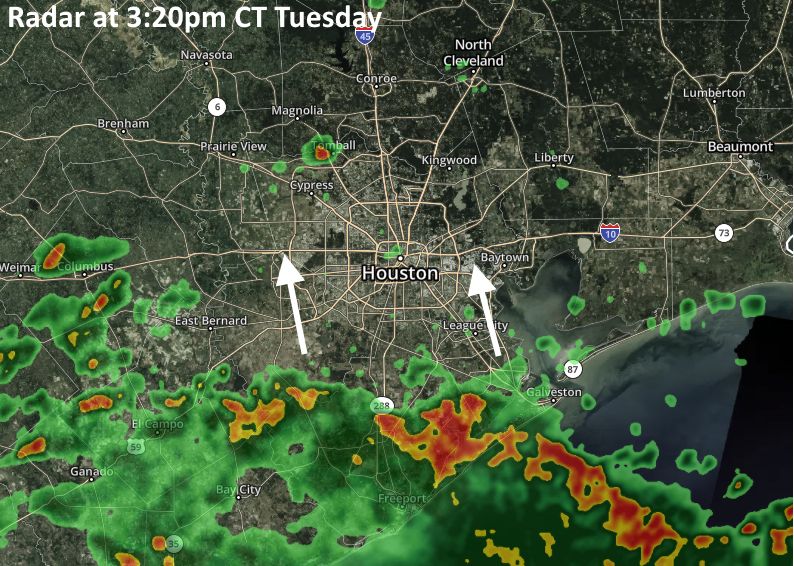
We anticipate that this initial round of showers moving into the coast this evening probably will reach about to Interstate 10 before winding down, probably by or before midnight. After this, models are indicating that a more organized band of storm activity will move into the coast between midnight and sunrise Wednesday. This could occur anywhere between Matagorda Bay and Galveston Island, although at this point I’d probably lean toward the southwest, and Matagorda/Brazoria county area. These storms may very well be efficient rain producers, with rainfall rates of 2-, 3- or more inches per hour, which will quickly back up streets.

It is not clear what happens to this cluster of rain showers, but if it moves into central Houston, it would certainly make for a messy Wednesday morning commute, so we urge you to be weather aware on Wednesday morning before you head out. And as always, please do not drive into high water. It is possible that showers become more scattered during the daytime hours on Wednesday, but this will likely only allow the atmosphere to recharge.
Wednesday evening through Thursday morning
At some point on Wednesday—will it be sunset? later toward midnight? who knows—it seems probable that a mass of storms will develop across much of the Houston area and slowly move from west to east. Again, the big concern with these storms will be rainfall rates which will have the potential to fairly quickly flood streets and rise into structures in low-lying areas.
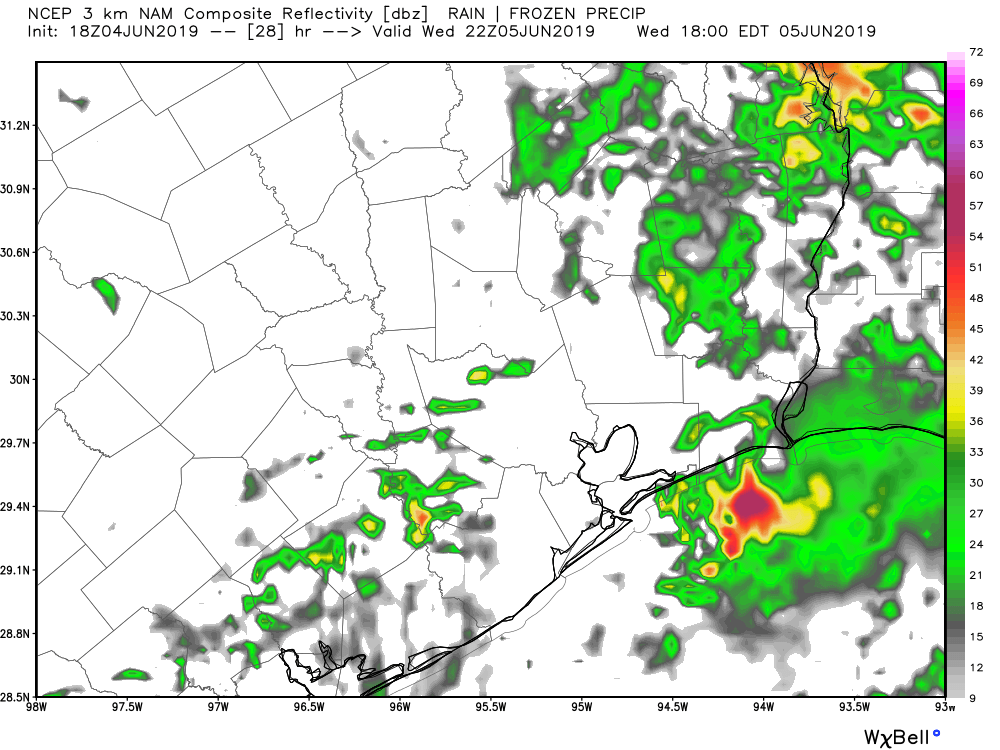
In terms of total accumulation for this event, I think we’re going to see widespread accumulations of 2 to 4 inches over the next two days. But the forecast models have been fairly persistent in bringing higher, isolated amounts of up to 10 inches, or more, to some areas. Whether that occurs closer to Matagorda Bay, Galveston Bay, or your home is simply impossible to predict. Hopefully the worst of it remains offshore.
We’ll have more tonight.
It is going to rain. Be aware, it could be heavy in spots. More details later. Thanks for your analysis. I know it is not easy.
This morning a friend of mine said, “First week of June? Reminds me of Allison.”
I told him that it so does not and that I need to find new friends.
🤣 your friend may want to check out this new site called Youtube.
After the Harvey Flood due to Conroe releasing the water from the lake. What are the chances this may happen with this storm? Thank you as always
Oh no it is barely June and we are already fearing floods from the tropicals! Thank you Eric for your words of wisdom. I just called my dear Fulgencio and warned him to not watch the televisions but wait until I get home so I can prepare him for maybe floods. Even this call of comfort seemed to be bringing the tears I should get home soon!! Blessings to all I hope the rains do not bring problems!
Lol wut? Who is Fulgencio?
hmm, looks like I may need to make a beer run on the way home tonight.
Mr Berger, long time reader here since your Chronicle days. Any idea of how this is going to affect The Woodlands area?
The Woodlands is probably going to come out of this in fairly good shape, as it seems like the heavier rain will (mostly) be along and south of I-10.
Is i10 the new/likely divider. Reports earlier were saying along and E of 59.
It’s fluid.
I saw what you did there!!
Good pun!
Well, I was going to hit you with a wet paper bag fit that comment, but then I tempered how spot on your forecasts have been. So, I agree, good pun
Well, I was going to hit you with a wet paper bag FOR that “fluid” comment, but then I REMEMBERED how spot on your forecasts have been. So, I agree, good pun
I read this with but moments to spare. All the cushions are out of the rain and anything that can move or fly around is secure. It’s raining and blowing in Pearland!!
Honestly after Harvey, everyone who was affected definitely feels some sort of panic with storms like these.
When stated “Again, the big concern with these storms will be rainfall rates which will have the potential to fairly quickly flood streets and rise into structures in low-lying areas.”
Do we have concern for flooding of homes, live in flood zone 45s/Beltway area should we be worried?
“Whether that occurs closer to Matagorda Bay, Galveston Bay, or your home is simply impossible to predict.”
You mean I can’t ask again about precisely how much rain will fall in the NE corner of my back yard between 2:06:34 AM and 12:04:15.234 PM?
😂😂😂😂😂😂
What about severe weather?
For the Champions area, NWS has raised the probabilty of rain to 90% tomorrow and has heavier accumulations between around 6AM and noon tomorrow–close to 2 inches during that time period–but overall accumulation over the next two days for Champions is still forecast to be around 3.75″
FWIW, Wunderground has 0.4″ by midnight and 1.9″ tomorrow for the SE side. So, as Eric mentioned above, your mileage will vary.