The big weather story for our week will be a slow-moving tropical system pushing into Texas beginning late Monday, and bringing the potential for heavy rainfall from Tuesday through Thursday. It still is not entirely clear where the heaviest rain will come, but there definitely is the potential for some 10-inch bullseyes, or greater. The region most likely to see this rainfall is somewhere between Matagorda Bay and Beaumont. We are more concerned about this event than we were on Sunday, and are forecasting it to be a Stage 2 flood event.
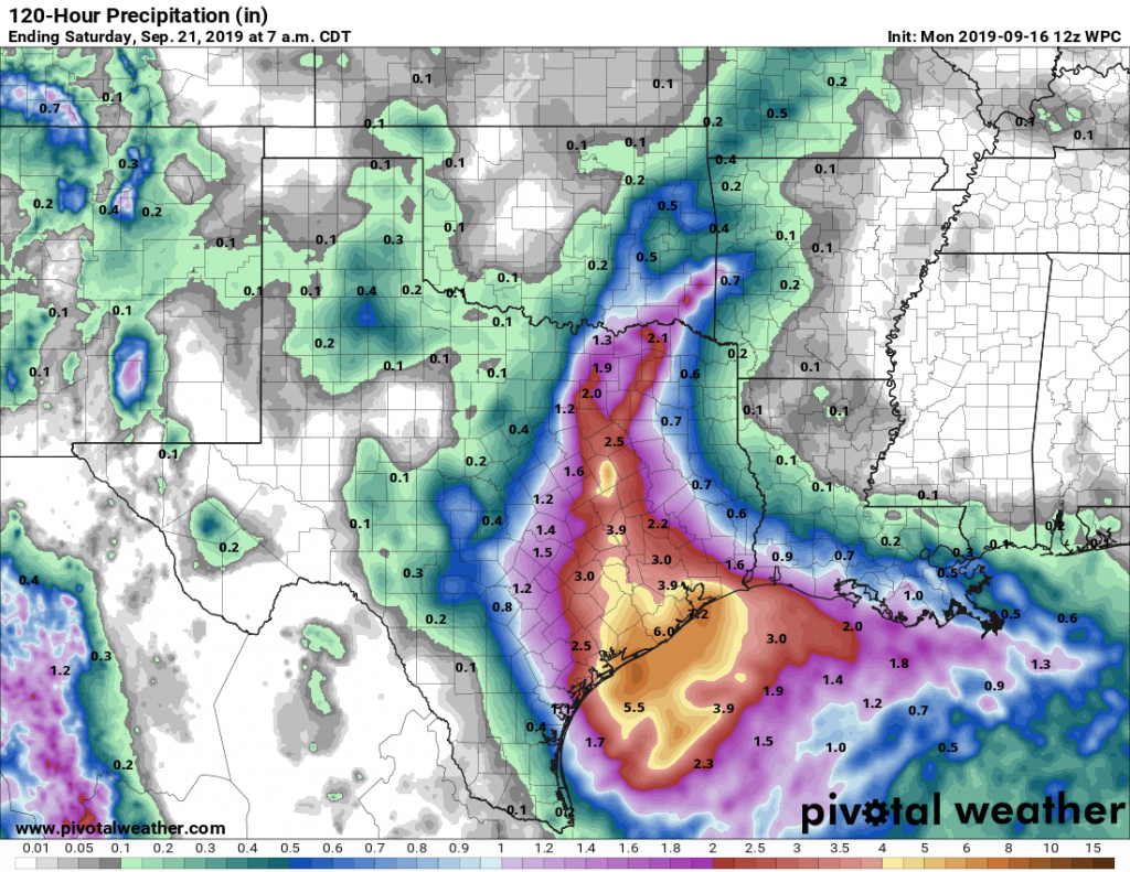
As of Monday morning, here are rainfall predictions from the National Weather Service and NOAA Weather Prediction Center for this system, and we see no issue with these forecasts after looking at the current models:
- Widespread rainfall of 3 to 6 inches through Friday
- Some areas are going to see amounts of 6 to 9 inches, with isolated amounts in excess of 12 inches possible.
- Rainfall rates of 2 to 3 inches per hour are going to be common during the event, which will quickly back up streets and push water into yards.
One problem with forecasting the locations facing the greatest rainfall threat is that this tropical system probably won’t move too much until later this week, as high pressure to the region’s north should allow it to meander for a couple of days.
To be clear, this is most definitely not a Hurricane Harvey type situation—it will not produce anything like Harvey’s totals, nor over such a large area. There also remains a reasonable chance—perhaps 25 percent—that the forecast busts and most of Houston sees 1 to 2 inches of rain this week. However at this time we definitely see the potential for flooding and are classifying this as a Stage 2 flood event on this site’s flood scale. For now, we don’t envision significant home flooding, but these are definitely “turn around don’t drown” conditions, during which isolated underpasses and high-water crossings may become life threatening.

The general pattern we can probably expect is for scattered showers on Monday and likely most of Tuesday. The period of greatest rainfall threat will probably come from Tuesday night through Thursday—with some of the latest models pinpointing Thursday as the day of biggest concern. Days will be mostly cloudy otherwise, with highs of around 90 degrees. Partly sunny skies should return by the weekend.
For those who live along the coast, we also have some high-water concerns as the low pressure system approaches Texas. According to the National Weather Service, through Tuesday morning, low lying areas along the immediate coast may experience minor coastal flooding during high tide times. Additionally, strong rip currents along Gulf facing beaches, and minor flooding along flood prone roads such as Highway 87 near High Island and Blue Water Highway may be possible.
We will update accordingly throughout the week.

Well, we need the rain…
How will this help abate the drought conditions for the general area?
It will be good for them.
I sure hope this refills the lakes around where I live… the combined heat and evaporation has given all the lake fish double whammies of hotter water AND more concentrated chemical runoff. Massive fatalities have been recorded by our local news affiliate WFSH.
Thanks Eric for keeping us posted! I think many of us will welcome the rain though!
Nice thundershower hit my home about 9 PM last night. Rained for maybe 20 minutes.
Same here! Short, but it rained hard.
Do we think that Katy should evacuate?
Oh come on now, this joke is tired.
Don’t like it? Don’t read it and don’t reply to it. It’s that simple.
Wow, thanks for the nugget of wisdom.
You are welcome! Have a great day!
That joke belongs to Houston SubReddit…
Katy will evacuate to Conroe when the green-sounding air horn blasts three short blasts. Or is that three long blasts?
Any update on the cold front mentioned last week?
This morning’s Euro is showing 20 inches total over Fort Bend and Brazoria and another 18 inch patch over Burleson and Robinson counties.
Good thing the Brazos is really low right now…
I really like your flood rating system because it guides our preparations and decisions.
Suggestion: provide links in your Historic Examples that give a good summary of each of the specific rain events.
People who have moved here in recent years will most likely benefit from such links. But even I, as a 30 year resident, draw a blank on many examples. I can recall some of them (generally, the most devastating and recent), but not most (older, local and limited in damage).
Apparently the recent NAM model shows 24 inches across portions of the area over the week.
Can’t post a picture of it here but the “simulated reflectivity” (i.e. future radar) of that same model run shows a tropical cyclone spinning on top of Harris County for three days.