Some of our best forecast models continue to indicate that the low-pressure system approaching the Texas coast is going to deliver on its promise of being a real soaker for parts of the state. We are also increasingly concerned about the flood potential from this system, but we cannot pinpoint where the greatest threat lies—although Houston is very much in the running for the highest rain totals this week.
What we know
The low-pressure system will approach the Texas coast on Tuesday, and likely move inland on Tuesday night or early Wednesday. There is a small chance it will strengthen into a depression or tropical storm near the coast, or just inland, but rainfall remains the primary threat.
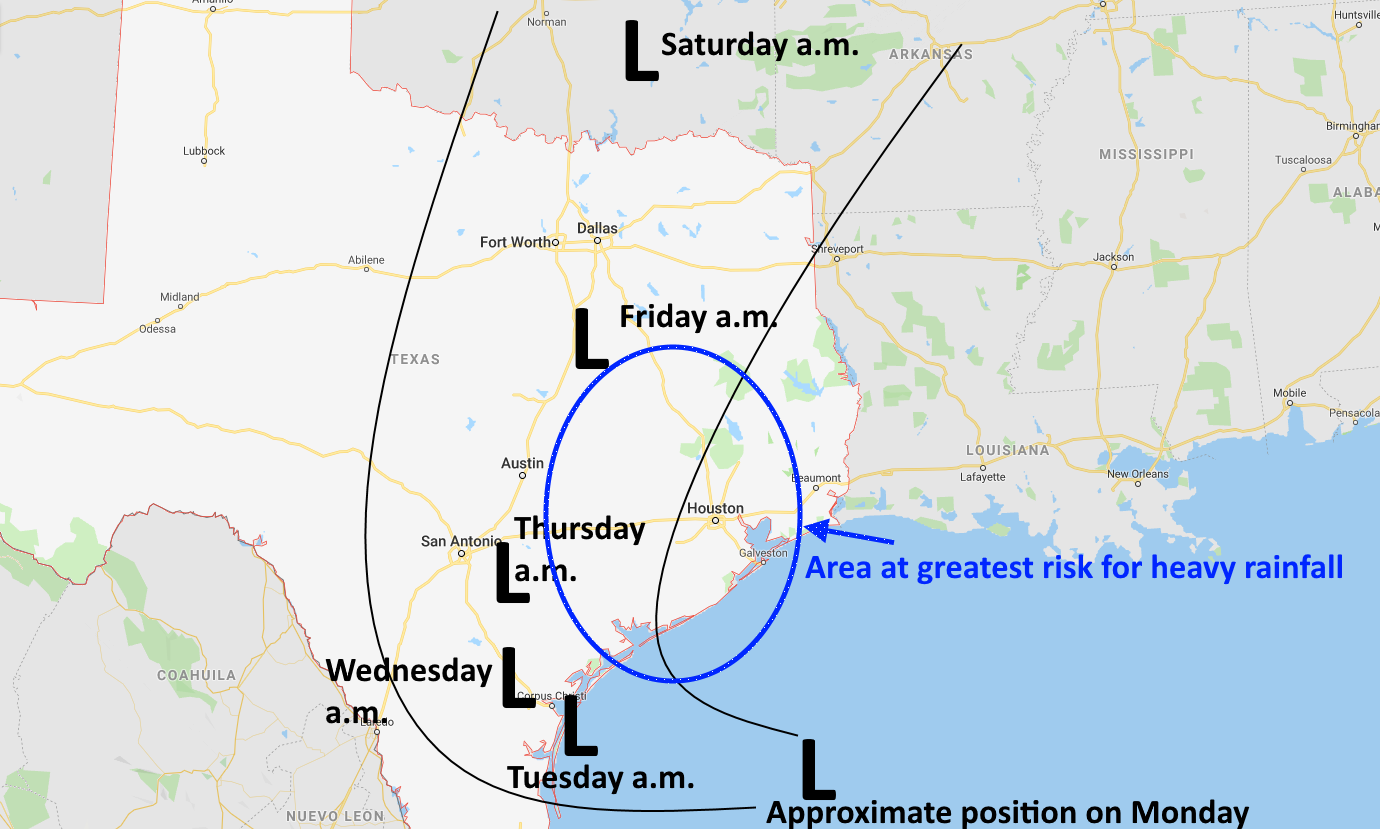
Once inland, the system is likely to wobble for a couple of days, as high pressure to its north prevents a turn in that direction.
What we don’t know
At some point the storm will begin to slowly pull north, and this likely will bring the stronger core of rains toward Houston. This period of heavy rainfall for Houston may begin later Wednesday, or early Thursday, but it’s hard to say for sure. Heavy rainfall is possible any time beginning Tuesday afternoon through Friday morning.
We don’t know where the heaviest rains will fall, and we’re probably not going to know much about exactly how much rain any specific location will receive until maybe Tuesday, or more likely later Wednesday—and even that’s not certain. That’s the reality of these events. We can offer ranges, but we’re not going to offer false certainty.
The forecast
If you’ve seen any individual computer model maps for precipitation in the coming days, please take each one with a grain of salt. Such maps are good for giving a sense of potential rainfall, but generally they’re pretty poor at determining precise amounts and locations. This map, of European ensembles, offers a rough guess at what we might expect.
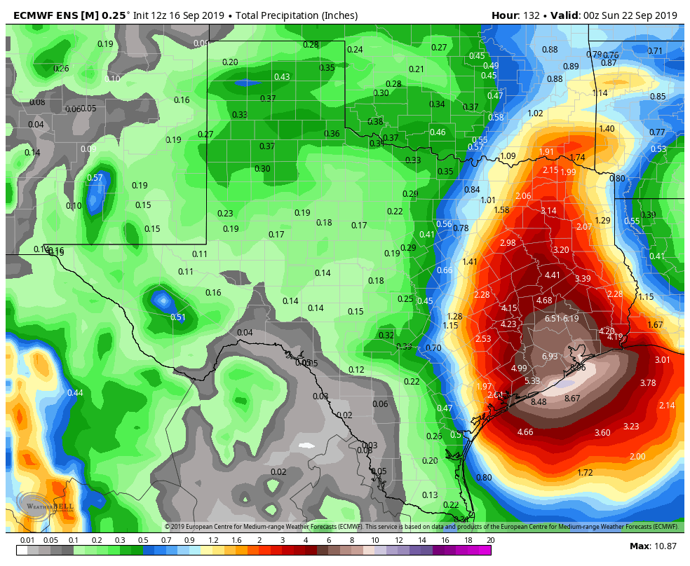
Overall, our forecast for rainfall between now and Friday for the greater Houston area are:
- Widespread total of 5-10 inches, on average, meaning that some some areas will see less, but some will see more.
- Bullseye totals of 15-20″ cannot be ruled out in a few isolated areas.
We still have a lot of questions about this system, most notably whether the heaviest rainfall will occur over an area such as Matagorda Bay, or Houston, or Beaumont, or—best case scenario—just offshore. But we do have serious concerns for Texas for the next several days. We will be watching this closely. Matt and I have discussed escalating this to a Stage 3 flood on our scale (we’re currently at Stage 2) but we’re not quite there yet.
We’ll have a comprehensive update in the morning. Also, as a reminder, if you would like complete updates during storms such as this delivered immediately after publication to your inbox, subscribe in the form on this page.

Thanks guys. I haven’t looked lately so thanks for keeping us up to date. Definitely looks like IAH/surrounding areas have the bullseye on us. Welcome moisture for sure. Yesterday PW was only 2.2 when I checked. Guessing it’s safe to assume they went up a tad.
Thanks Eric and Matt!
Hi Eric, is there a chance that the “area at greatest risk for rainfall” may drift west or is it likely to stay in the area it’s currently centered in? I live in Austin an am concerned about potential flash flooding should it drift away from Houston and move further inland if/when the storms reach Central Texas
Bring it
You’ll remember from Hurricane Ike that the most important question is how much rain we can expect in Katy. So?
Is there a way to auto-delete comments that include the word “Katy” – so tiring
So are the comments complaining about the hilarious Katy jokes. Katy brought this on itself so maybe you should try and have a little sense of humor.
I agree that the comments, AND the commenters, about Katy should be auto-deleted. I think we can say, since most of us flooded from Harvey, that we “got what was coming to us” for something that some Katy residents did 14 YEARS AGO. After Harvey, it’s very distressing to hear a system is coming out way and could bring 10+ inches of rain. I’m sick and tired of coming here to find info and seeing the juveniles who can’t seem to let it go and have a little empathy, instead of making the same old, tired, stupid joke.
Dude I know right, every time a storm is coming I can’t wait to be the first one to jump on and do the Katy evacuate joke its like so funny LOL I tell everyone about it at lunch the next day at school its awesome all my friends think its really funny too, haha why would katy evacuate they arent even close to the ocean and its funny cos someone like 10 years ago asked it in a serious way, i love when everyone posts it every time it never gets old
Anita and Chad are upset, so everyone knock it off!
Chad and Sam, you’re just reinforcing my point…a bunch of juveniles. Go get a life and leave Katy alone. And Chad, perhaps you should start paying a bit more attention in school in order to learn how to write a coherent thought.
They’ll never take away my right to regurgitate le epic tired old memes like a trained monkey!
It appears that this storm has a large eye and the top band is moving north of Houston. What is going to happen to bring the significant rain fall?
Thanks Eric & May for always shooting straight and not hyping things for no reason. I know I can always trust you guys to give a real forecast with no nonsense!
You can’t be serious.
This is either just amazing satire or mad ramblings. Maybe both. Either way, I love it.
Just because YOU don’t understand weather and climate doesn’t mean no one else does.
Thanks for the update. I always look to you guys first and trust what you have to say over the other weather sources. Appreciate all the info!
Thanks for the update. Can you offer any insight into way the Euro models are saying huge amounts more (for my area of Walker county) than other models? Or can I try to ignore that model?
I wonder about that too…it’s showing a lot more rain in their forecast than the others.
Yes, ditto on the questions about rhe euro model. But also since clear creek (and buffalo bayou) depend on the level of clear lake (and galveston bay) for runoff to have a place to go … do we have an idea of surge and tides (and onshore flow etc.) impact yet?
When you guys are worried, which it aounds like you are, i come unravelled a little bit.
Thank you!