Strong showers and thunderstorms developed on Wednesday evening, quickly dropping 2 to 3 inches of rain over parts of northeast Houston, near Humble. Other areas of the city also saw briefly strong storms with incredibly loud thunder. We still anticipate this heavy rainfall becoming more widespread this weekend, and due to the potential for street flooding we remain under a Stage 1 flood alert for the entire area.

Thursday
Today will be similar to Wednesday in that the daytime should see a mix of sunshine and clouds, allowing high temperatures to get into the upper 80s. As the temperature rises, we’ll see an increase in rain chances this afternoon. Rains will likely start somewhere near or just south of the Interstate 10 corridor, and then slowly lift north. I suspect a few areas will again see bullseyes of 2 to 3 inches of rain today, with most of the area seeing significantly less. Rain chances get lower after sunset.
Friday
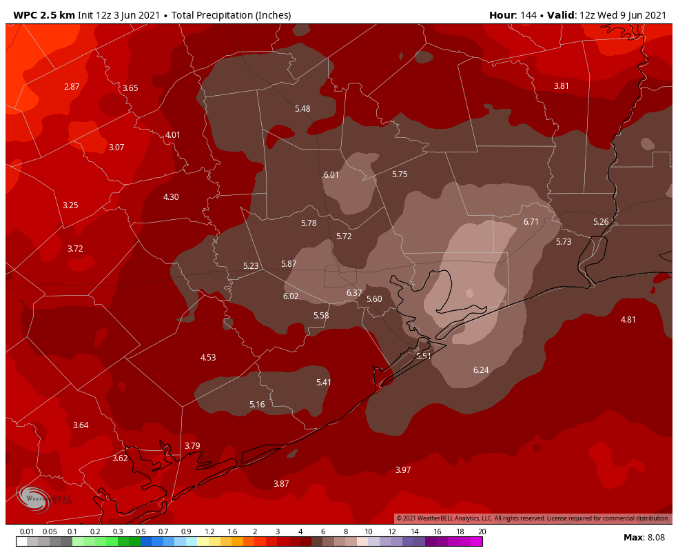
At this point, it looks like conditions will favor more widespread rainfall on Friday, with 0.5 to 1.5 inches for much of the region, and higher isolated totals. Friday begins the period of biggest concern for us with these rains, and it will run through about Monday. As is typical with this kind of system, it can be difficult to predict exactly when and where the heaviest rains are going to fall even a few hours beforehand.
So what is this system? Essentially, a slow-moving upper-level low will move across the mountains of northern Mexico into southern Texas on Friday. Then it will meander across the state, with disturbances rotating counter-clockwise around its base. As it does so, the upper-level low and its associated disturbances will draw the Gulf of Mexico’s ample moisture into the coast, and this will set up a wet pattern that we won’t break out of for several days.
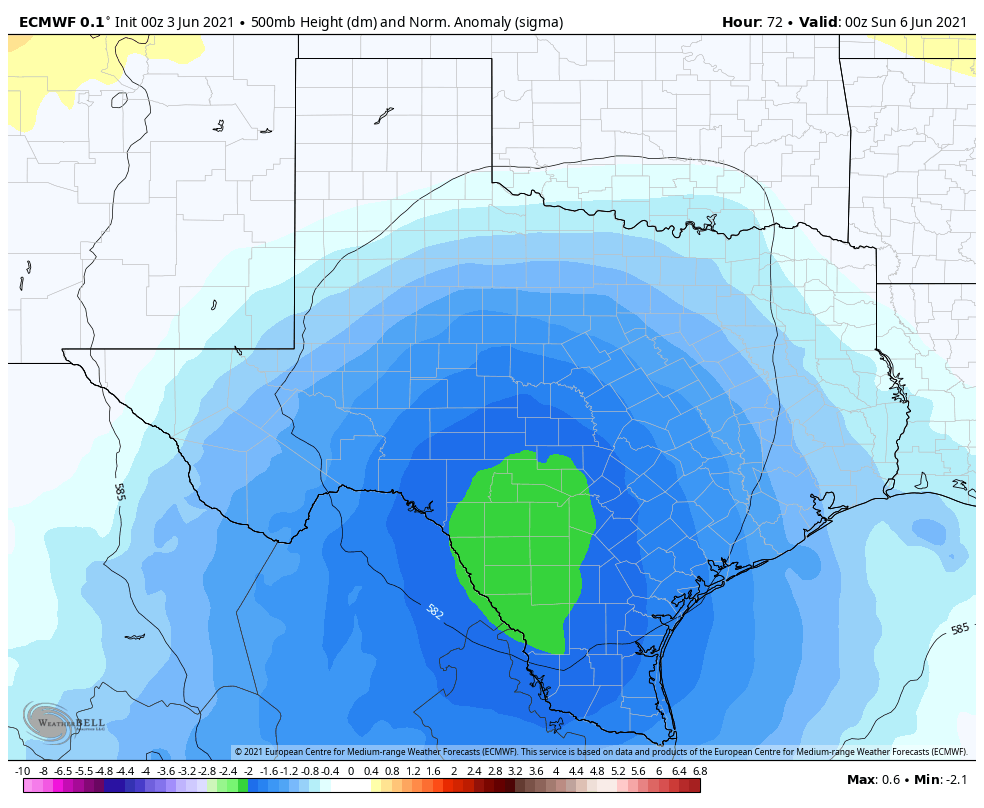
Saturday, Sunday, and Monday
This setup will generate periods of heavy rainfall along the Texas coast this weekend and into Monday. With access to the Gulf moisture, these storms will be capable of producing rainfall rates of 1 to 3 inches per hour, and this quickly backs up streets. It looks like the peak of activity will come from Saturday afternoon through Sunday morning, but again, confidence with predicting specificity this far out is low. Bottom line: prepare for heavy rain this weekend. We expect widespread accumulations of 4 to 6 inches, with higher localized accumulations. Matt and I will be watching all of this closely to keep you informed.
Next week
So when does this mess move on? Rain chances will start to slacken by Tuesday or Wednesday, and we think building high pressure will shut the spigot off by later in the week. Probably. Hopefully.
Hi Eric, do you think I-10 through Louisiana will be affected by our rain here on Saturday and Sunday, going through Louisiana on Tuesday. Is the low heading their way after it passes us?
Any concern over no high pressure sitting over us with upcoming hurricane season? Isn’t that what typically keeps hurricanes from landing around here?
Would rather it hold off until August/September when we’re more likely to need it.
I believe we don’t get the big High Pressure gradient that often wards off storms until early July or so. Think that’s why we’re succeltible to early hurricane season storms such as Allison in June, 2000. Just my thoughts
So is this recent wet pattern related to El Niño or something else or just luck of the draw with multiple disturbances crossing our path. Are we above avg rain for the year so far and was this the general expectation back in January? Just curious
Thank you so much for the forecasts. Looks like I won’t be making any plans this weekend.
Incredibly loud thunder indeed. We have lived in Bellaire for over 40 years and have never experienced but once before such loud thunder. It was truly frightening. The loudest we have ever heard was around late last fall when a boom sounded like a bomb had detonated outside our home. It blew out everything that was not power protected. Thanks guys for all your help in keeping us up to date on our weather.
Do you think it will be bad on Sunday afternoon in the League City area? I have my baby shower that day and was hoping to get lucky with no rain lol.
I would not be confident in the weather on Sunday afternoon, Ashlin. But it’s possible that the atmosphere is worked over by then, and we see a break in the storms.
As I’ve said before, come ONNNNNNNNNNN. This is ridiculous. We have two seasons here – monsoon, and wet ice. 🙁
Thanks for your constant vigilance, though. It is much appreciated.
Lets addendum that to say blasting hot monsoon.
No rain at all around Ellington yesterday.
Since I’ve been following you for quite a long time (Chronicle) and it was put on hold for a while due to Harvey but…should Katy evacuate😁
You and Matt keep doing this great service for all of us here in Houston and I am very thankful and appreciative.
2.15 inches in 45 minutes this afternoon up in the Champions area, still pounding down. My drains are overwhelmed.
Curious how often weather comes from the mountains of Mexico across Texas? TIA
I agree with that comment in the Chronicle a couple of weeks ago. The drought is over so people can stop praying for rain!