Well, it’s Labor Day in Houston, and unfortunately some outdoor activities are likely to be a washout during the middle of the day. The good news, however, is that our overall concerns about the potential for heavy rainfall during the next seven days have lessened. So let’s discuss conditions today, and then later this week as Tropical Storm Gordon moves into the northern Gulf of Mexico.
Labor Day rains
Houston, so far, has mostly been dry overnight. The heaviest rainfall overnight has come to the east of Houston, from the east side of Galveston Bay to Beaumont and Lake Charles, where there are several flood warnings. This is where the greatest risk will remain this morning, although some of the heavier showers are now pushing into coastal areas south of Houston, including Galveston, and up the Highway 146 corridor into Baytown. High resolution models suggest these showers will fill into more of the Houston area later this morning, and early afternoon, as a broad low-pressure system moves over the area.
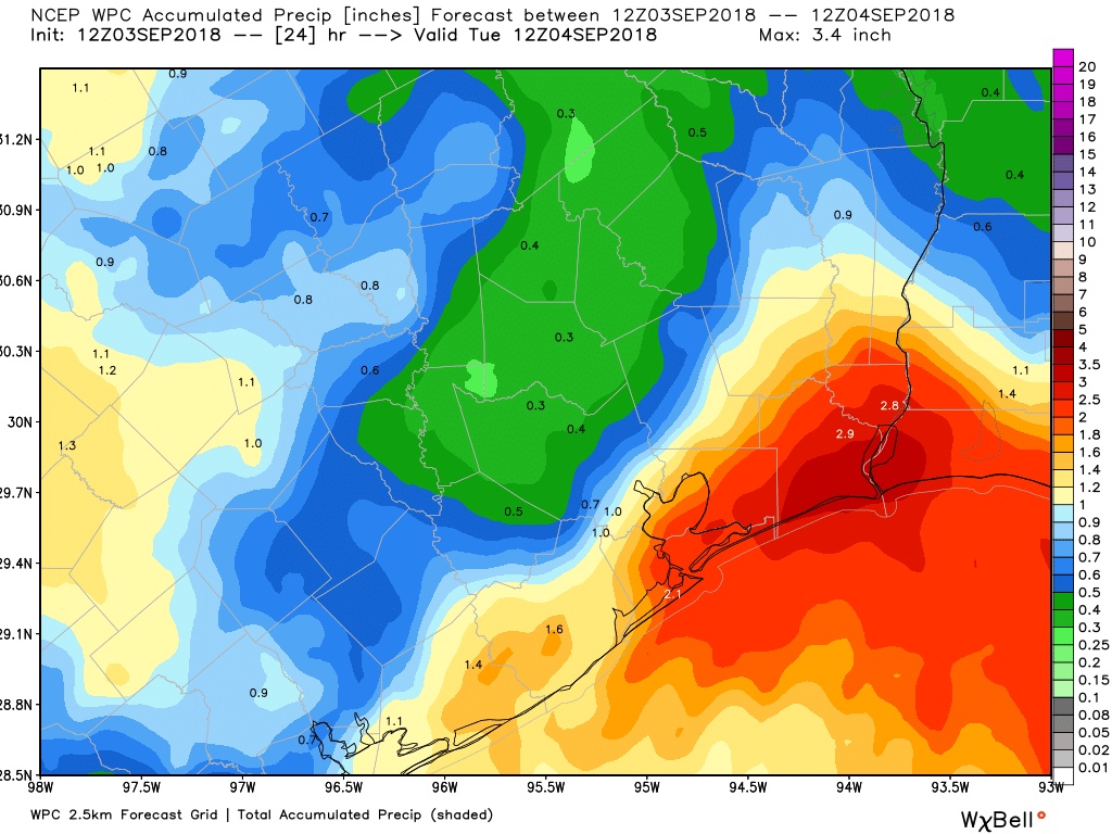
However, our overall concerns for flooding today remain fairly low in Houston, especially for areas away from the coast and Galveston Bay. Street flooding may be a problem beneath the heavier storms, but for the most part rains will be entirely manageable. A Flash Flood Watch remains in effect through 7pm for Houston, but rain chances should fall off later this afternoon—if you’re planning a Labor Day cookout this evening I’d be reasonably confident in good weather—and during most of the overnight hours before scattered to widespread showers return Tuesday. This may bring an additional 1 inch or less of rainfall to the region.

Tropical system
Further afield, the center of Tropical Storm Gordon is moving over southern Florida and the Keys this morning. Forecast models are tightly clustered along a northwest track that should bring Gordon to southeastern Louisiana or the Mississippi coast by late Tuesday night or Wednesday morning. It probably will be a strong tropical storm at that time, although we can’t rule out a hurricane.
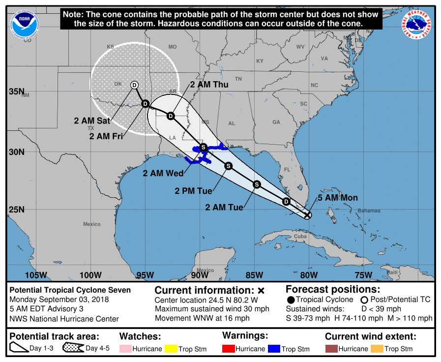
As for Texas, the region should be on the “dry” side of Gordon, leading to lesser chances of rainfall on Wednesday and Thursday of this week. Fortunately, we are now less concerned about the potential for a “stalling” scenario in which Gordon moves into Western Louisiana or East Texas later this week, slows down, and dumps a lot of rainfall. Rather, it now appears likely that Gordon will continue to move northwest, before eventually getting pulled to the northeast after interacting with a storm system in the mid-latitudes.
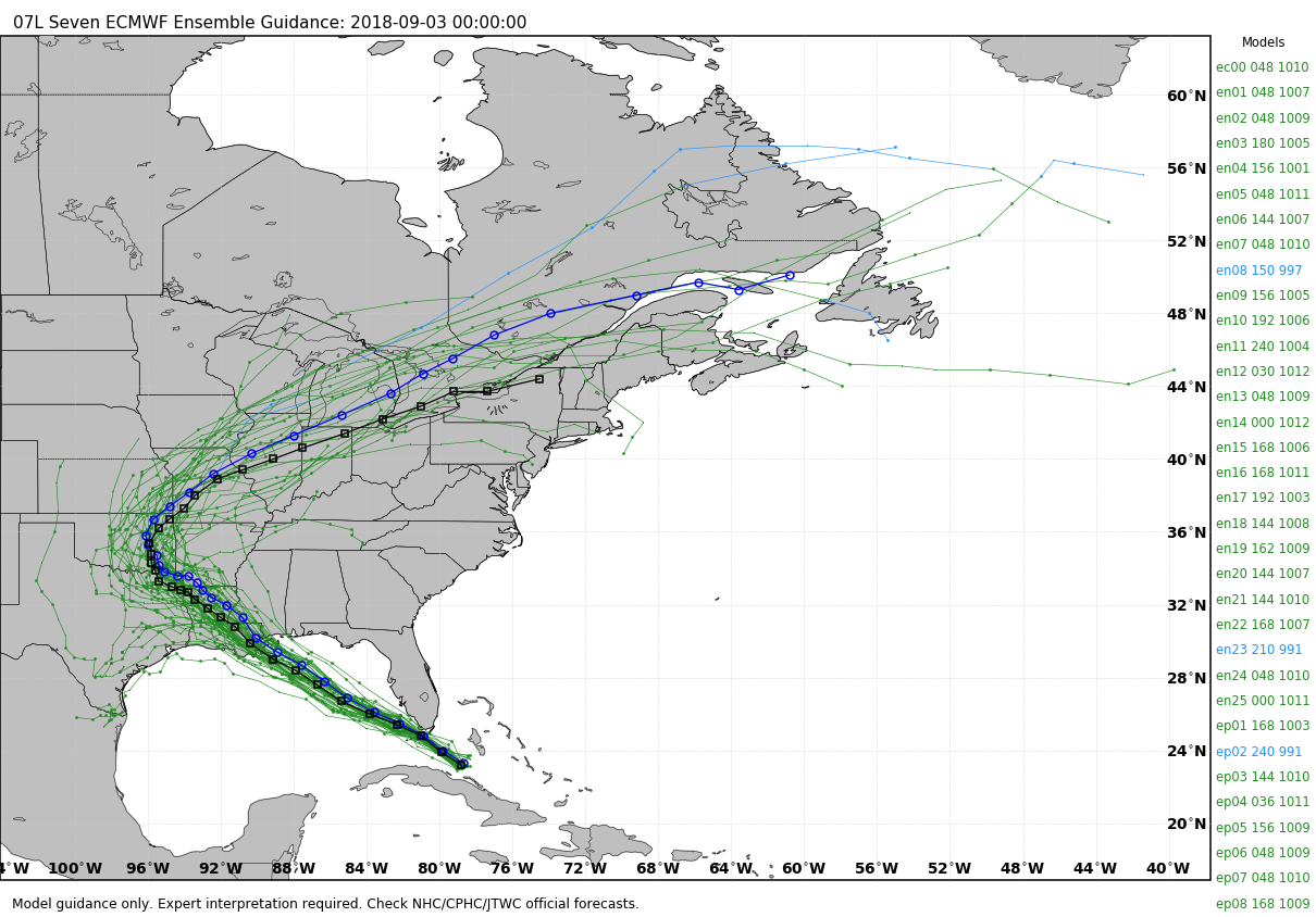
The upside of this for Houston is that, while next weekend will carry a healthy chance of showers (probably 30 to 50 percent), we are no longer particularly concerned about the potential for very heavy rainfall or flooding at this time. As ever, we will have to watch this system, but you should only be aware, rather than overly concerned.
Nooooooooooooo! 😢. We desperately need rain in Angleton!
Thanks for your info and working the weekend, what are your thoughts for the rest of the Texas season?
Thanks again
I’ve already had 5″ in the past week (including 1.5″ between 10:45-12:30 Sunday mid-day).
I think that’s enough.
Thanks, Eric. I’m still amazed that television weather forecasters (who I won’t name) spent part of this morning flogging “no one is certain where this tropical storm will go…here’s the forecast track that takes it away from Houston, but there is a LOT of uncertainty, so we need to be VERY cautious about not paying attention…” It just goes on and on. I know they need ratings and are in a competitive environment, but wow. The hype machine continues to dominate. Thank you for your solid scientific weather reporting.
This morning?!?
Thanks Eric for that question ( “This morning?”). It speaks volumes. No hype means a lot to us.
Ha. Yes. I guess I should have said “every morning, afternoon and evening, as usual”. It was just that I was reading this while TV was blaring out its “news”…
WaTcH oUr CoVeRaGe We NeEd ThE mOnEy………………
That’s actually not “hype”; anytime a storm is in the Gulf and heading what still is our general direction, you should keep close tabs on it. Only takes one scoot to left to make it a concern for us
I just read an online report from one of the news stations that contradicted itself multiple times about this storm. These people at the news stations are so irresponsible. I came here to read the true forecast.
Thanks. Yesterday Travis Herzog was talking about “20 inches” of rain. I appreciated your “this isn’t Allison” comment, and today’s forecast. Next Saturday is a party for my parents’ 45th wedding anniversary, and next Sunday my church is supposed to move back into our building (near Buffalo Bayou) for the first time since Harvey. I’d really rather Houston not be underwater again!
We can be pretty confident Houston won’t be under water.
However, unfortunately I can’t promise sunshine for moving day.
LOL thanks. It’s ok, My description was misleading… I think stuff is already all in the building. (Thankfully we had a big upstairs for storage while the downstairs was being rebuilt.) Sunday is the first actual worship service back in the building. As long as people can get to the church, we can carry on!
I noticed the NHC rain prediction tool appears to be predicting more rain to the dry side of Gordon. Just an observation.
I’m not really seeing that here: https://www.nhc.noaa.gov/refresh/graphics_at2+shtml/092142.shtml?rainqpf#contents
No one can be certain on where it goes Harvey was never supposed to come towards Houston…rather than saying it’s unlikely that I storm will come our way I would say be prepared for the worse hope for the best
This is wrong.
Several days before Harvey’s landfall we had confidence in a landfall near the central Texas coast, and then a meandering storm inland that would bring heavy rains into the upper Texas coast, including Houston.
Actually we knew Harvey was going to be bad for Houston about 36- 48 hours out from landfall..We already suspected that Harvey would hang around our area for a while, dumping rain…This is a good amount of fairly accurate info to have at two days out..I based my decision making on this info..
It’s raining and storming like a sob in Galveston!p right now!
Yep, you’re getting the full brunt of the low-pressure system. Still expect it to weaken later today.
Your commentary is so valued as many have stated. The local “the sky is falling” weather casters seem more concerned about viewers than passing on intelligent information without all the drama. Thank you so much for continually debunking their rhetoric. H
Raining pretty steadily in Copperfield @ 9am…
Thank you Eric!
Came here to say that I really like your work. My friends and I read your report every day. Also, I’m very much aware and appreciative that Reliant is sponsoring you. I think that’s great and hope they continue. Thanks.
Thank you Marc! I know Reliant appreciates messages like these.
I just discovered your forecasts this summer and am spreading the word about how nice it is to have the objective reporting you consistently deliver. Thank you!
Thank you, Thank you for posting the facts with no hype! It bring great peace to read your posts everyday. And a HUGE THANK YOU to Reliant for the sponsorship ♥️♥️♥️
My Total rainfall for the last 24 hours was 3.42″ I am a CoCoRah’s volunteer. Live off of El Dorado near Friendswood. It is still raining but it is light.
Best weather reporting for the Houston area!!! Thanks!!!
I think I’ll wear my Space City T-shirt all day today and into the week….. Just so people know that I don’t listen to those “other” guys!! But can we PLEASE make it stop raining along 146??? We’re getting drenched in La Porte! LOL
The fellow on channel 13 was doing a live stream this morning. He kept saying that downtown was going to get socked as the storms “fill in.” Trouble is, they’re not filling in. We have a typical rainy day in Houston and he’s hyping it like Harvey II.
We’ve got 1.65″ this morning in Champions. Looks like car paths only this afternoon on the golf course, umbrellas handy. Or stay inside and have a beer and watch golf on TV.
Downtown got socked around noon and it rained hard through the second inning of the Astros game. Lots of very wet fans this afternoon!
My grass and plants say “thank you” for the rain, and my heart says “thank you” that we aren’t flooding. I also say thank you, Guys, for your informative updates without the hype. You’re greatly appreciated !
You guys are the best! Thank you Reliant for sponsoring Space City Weather. You are doing a valuable community service.
I have family taking my kids to Florida on Wednesday morning, driving from Houston to near Destin with hopes to arrive by Wednesday night. Any areas of concern with flooding or anything we should be watching out for as they plan the drive that goes right through the current path of the storm?
Two words….. TROPICAL STORM
Regardless the strength of the storm, flooding is always a concern with tropical systems. Also the current NHC prediction has the storm moving in around the New Orleans area and continuing to move to the Northwest. Remember the wettest side of the storm is usually on the East side. So saying that, I would keep a close eye on the forecast, to include delaying their departure to Florida
I would recommend that their departure to Florida be delayed. Current prediction from the Hurricane Center has the storm inland at 8am Wednesday over IH 12 and IH 10 in Louisiana. Areaa east of that location could received a lot of rain and flooding.
Over an inch in the past 45 minutes.
Over 1.5″ for the day… and counting.
Obviously, everyone reading Eric’s posts is a fan; here’s an article that solidifies his mastery of the science of weather…and how Eric brought humanity to the science during Hurricane Harvey. Just as a “thank you”, I’ve followed Eric since discovering him on the Chronicle when he first out-shone all other weather forecasters. https://bit.ly/2BEo8ko
Great article! Eric Berger is a good man. He writes honestly and without the normal alarmist undertone we get from TV.
I know it must be an enormous pressure for him to “get it right” which, with weather, there’s always such unpredictability.
Keep up the awesome work, Eric!!!
I apologize for the multiple posts, but I kept getting error messages saying my comment was not posting. So I did not realize they actually were being published.
No worries. Posts with hyperlinks are by default held for moderation as part of the site’s anti-spam settings, so that might have been part of the problem.
Eric / Matt – which model was it that showed a Florida St. – wide left – towards Texas once storm made landfall? And what characteristic changed it?