Good morning. Before jumping in to the forecast, I wanted to spend just a moment discussing why some areas of the region will see snow on Sunday night and Monday, and others sleet or freezing rain. It has to do with the temperature in the column of air above the surface, through which precipitation falls.
Snowflakes form high in the atmosphere, and if the temperature remains below 32 degrees as they fall thousands of feet to the surface, they remain snow. However, if there are pockets of warmer air and then sub-freezing temperatures again, sleet will form as snowflakes, melt, and then re-freeze as small ice pellets. And finally, if there is warmer air near the surface, but not at the surface, we’ll get freezing rain. The graphic below helps depict these processes.
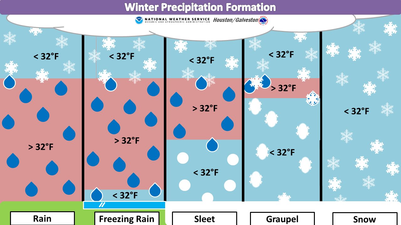
This is the primary reason we think freezing rain is most likely near the coast—where the Arctic air mass will be most modified by the warmer Gulf of Mexico near the surface—and snow most likely over areas well inland. In terms of roads and potentially power lines, freezing rain is most problematic because it only takes a little to stick to roads and make them icy, and not that much more to accrue on power lines and weigh them down, or become more susceptible to blowing winds.
We’re starting to get closer to Monday, so higher resolution models are beginning to come into our forecasts, and as they do so confidence in which types of winter precipitation, and how much will fall, will increase.
Saturday
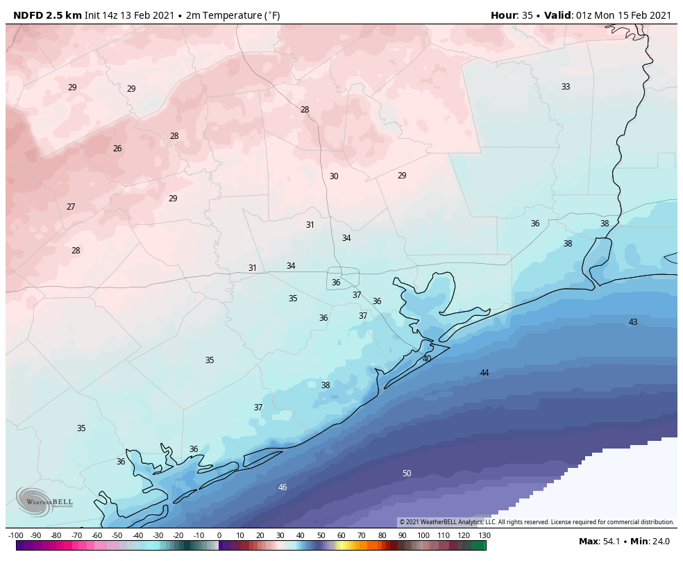
Temperatures are above freezing across the Houston area this morning, but only barely. They won’t rise a whole lot today, likely only reaching the upper 30s in Houston, and near 40 degrees along the coast. Buy hey, that’s better than freezing, right? In terms of wintry precipitation, our concerns now begin tonight for parts of the metro area northwest of a line from Katy to Tomball to Conroe. This is because lows for those areas are now expected to fall to about 30 degrees. This, in concert with light precipitation, could lead to some icing on elevated roads and bridges.
Sunday
Highs on Sunday should get into the mid-30s for even these inland areas, and warmer in Houston itself, so traveling across the metro area after mid-morning on Sunday should be fine. But the further west and north you go, you’re still going to run into freezing conditions.
Conditions begin to deteriorate by around sunset on Sunday in Houston. This is when we expect widespread precipitation to move into the area, and temperatures to begin to fall below 32 degrees. Some inland areas won’t see above freezing temperatures again until Wednesday.
Sunday night and Monday
This is when conditions on area roadways will become treacherous. As noted above, we expect snow to fall across inland areas where temperatures are the coldest, but we don’t know where snow will switch to sleet, only that this line will likely be somewhat north of Interstate 10. In terms of accumulations, here is our best forecast at this time, but it remains highly subject to change as additional high-resolution forecast models enter the picture.
Snowfall: For areas that receive it, about 1 inch, with 2 or more inches possible for Conroe and areas north of there.
Sleet: About 1 inch for central parts of the Houston metro area, with less north (where there will be more snow) and south (where freezing rain is more likely).
Freezing rain: About one-quarter inch for areas along and south of Interstate 10.
It now appears likely that precipitation will wrap up by around Noon on Monday, if not shortly before. Unfortunately, because temperatures at that time will probably only be in the low 20s for most of the area, whatever falls on the roads is not going anywhere. Moreover, with winds gusting out of the north above 30 mph, especially along the coast, it will feel like 10 degrees or below. Finally, these winds could play havoc with iced over power lines. So yeah, Monday is a day to stay home and hunker down.
Tuesday
After the precipitation ends, skies may begin to clear overnight. With extremely cold air in place, this will allow for ideal cooling conditions heading into Tuesday morning. And it will be exceptionally cold for Houston. Areas where there is snow on the ground, well west and north of Houston, may see temperatures of 5 to 10 degrees, and the coast will only be marginally warmer, in the low 20s. (The all-time record low for Houston is 5 degrees, set in 1930.)
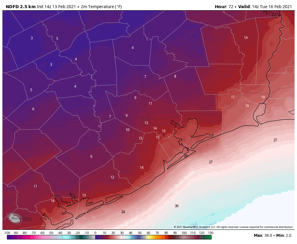
Temperatures should reach above freezing, if barely, for areas south of Interstate 10 on Tuesday. But areas north of that line may continue to see freezing temperatures throughout Tuesday and Tuesday night. Lows will not fall much Tuesday night.
What this all means for roadways in the Houston for Tuesday morning and beyond is unclear. It will depend on how much precipitation falls Monday, in what form, and whether efforts to de-ice roadways are effective. I can offer no good predictions here, sorry.
Wednesday, Thursday, and Friday
Unfortunately, another round of precipitation is likely on Wednesday, as moisture moves inland from the Gulf of Mexico, and another front approaches. This will fall as rain on Wednesday, but for inland areas at least it could turn into sleet or freezing rain on Wednesday night—at least for areas along and north of Interstate 10.
The details of this are still very much in flux, but there’s a chance for more icy roads on Wednesday night and Thursday morning. At this time we do anticipate less impact than we’re likely to experience on Monday. Lows drop into the 20s on Thursday night, probably, before finally warming well above freezing on Friday.
And that’s the end. Saturday should get into the 50s or so, and by Sunday we’re back to highs in the 60s. Until then, it’s going to be absolutely frigid. Stay safe, y’all.
Matt will have a brief update on the forecast later today, and also take a first stab at historical significance of this kind of winter event for Houston.

Is gruapel what we referred to up north as ice pellets?
Possibly. I’m a Houston native that’s lived in the Northeast for the past decade or so. I’ve heard “ice pellets”, “sleet”, and “hail” used interchangeably for the same in-between precipitation. The latter one really bothers me though since hail is pretty specifically a thunderstorm phenomenon and not a winter precipitation phenomenon. No matter the name, it’s not worth driving through unless the roads are being treated!
I think so! Graupel is more like a rain drop that freezes on a snowflake. We used to call it pellet snow or rimmed snow in NW Indiana.
Any views on areas to the NE, around Livingston?
Thank you for the service you provide to the community and keeping us informed. This is extremely helpful and it’s the first thing I look at every morning. Stay safe.
What about Beaumont?
Do you think this will impact flights from IAH on Thursday and Friday?
National Weather Service forecast for the Champions area is that it will be 32 degrees or lower from 8PM Sunday all the way to 9AM on Wednesday, bottoming out at 11 degrees on Tuesday morning! Monday will not get out of the teens. My house (pipes) have never experienced such an event. Time to head to Spec’s….
Thanks guys. Who knew we’d need the same high quality, chock full of useful info, no-hype weather reporting in the winter as we need during the hurricane season? Many of us truly appreciate having a reliable weather information source.
Thank you for your updates! Best weather website out there!
I hate to be dense, but what about the Kingwood area?
We have a houseguest that was supposed to fly out on Tuesday. Any ideas when they will be able to leave??
Thank you Eric and Matt for all you do. A train leaves Chicago traveling west at 60 miles per hour. An hour later, at 12 noon, another train leaves Chicago traveling east at 80 miles per hour. When are the two trains the same distance from Chicago?
Never happens. The one traveling east gets real wet as it dives into Lake Michigan.
What are the chances we lose power? Is there anything we can do to prepare?
There is a chance that you could lose power either from rolling blackouts (due to high energy usage) or from powerlines down. Preparations are similar to other power outages except you’ll want to make sure you have extra warm clothing/blankets at the ready.
I turn to your site everyday because y’all not only. give facts, but you go beyond to help me understand those facts. Thank you so much! BTW, I live in Ft Bend (Richmond) which doesn’t get covered. Is this your policy?
Never been thru this before – so need guidance – i read the links, but none of them mention turning off water to house and draining pipes – only to drip all faucets, but City of Houston Water website has a notice to shut off water main and drain pipes, lest the water surge drop water pressure for everyone and pipes will burst……..is this right? I haven’t received any notices (i am signed up for alerts) – it appears to be only on their website if you just happen to go there (i was paying my water bill).
Insight from those who know what we really should be doing? (I follow the usual plant, pipe, etc. rules) – just first time i have heard about actually turning off water main to house.
I get my info from my old-timers who have been around to see these events. Us with homes that were built with galvanized pipes really worry about these hard freezes and turn the main water off over night. (And drain the lines). If someone know differently, please share.
At the very least everyone should know where their cutoff valve is and how to shut off their water. You may have to use a tool to get a good grip. And you don’t want to figure that out in the dark.
I just had some plumbing work done and was quizzing my tech. If you do turn off the water at the main, when you turn it back on, do it slowly, in steps. Galvanized pipes will have a build up inside the pipes and if you blast the water on, it could loosen some of the build up which might cause a blockage at some point. I asked him repeatedly about turning off the main, but he said I should be fine. I am on a well, instead of city water, not sure if that would make a difference, but he said that the temp of the water out of the ground is much lower than freezing which would also help keep the pipes from freezing as long as it’s moving (dripping faucets). I also read that if you wake up in the middle of the night, or just randomly through the day, run the water periodically in the sinks and tubs, run a load of dishes in the dishwasher, laundry, etc. to keep the water moving. Especially at night, use delay start if needed. ALSO that having the faucets open a bit will relieve pressure on the pipes. So. I’m still freaking out, even though during the ice storm of 1997 I lost power and the temp in my house was 35 and I had no damage….that time… ugh…
The HRRR (hi res) model now shows 6 to 8 inches of snow in our area and less freezing rain
Thanks for everything guys! Having lived up North for 8 years, it is nice to see people learning about freezing conditions down here and becoming familiar with how to deal 🙂
One question though… Does Katy need to evacuate?
Keep it up! I love your site!
Would you please include a date and time of publication in your always important daily forecasts? Please. Maybe next to your name?