Houston’s seemingly unending summer continues this week, with little break in the temperatures, humidity, or in a few days, rain chances. We’ll also discuss a tropical blob in the northwestern Caribbean Sea that ultimately shouldn’t have much effect on the region’s weather.
I was asked in a KUHF radio interview on Tuesday about the lack of fronts this year, and I said the most depressing thing about it is that we’re missing out on potentially great weather. October and November often see some of the nicest weekends of the year, and none of these are yet in sight. It’s a rather lousy thing.
Wednesday and Thursday
Some dense fog has developed over central and northern parts of the Houston area, and the National Weather Service has placed an advisory in effect until 10am. After this, weak high pressure should allow for partly sunny skies on Wednesday and Thursday.
Some areas will still see rain showers and possibly thunderstorms over the next two days, but accumulations should not be too significant—likely in the tenths of an inch. Highs will be near 90 degrees both days, and may reach that mark where skies are sunnier for longer.

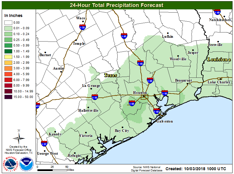
Friday, Saturday, and Sunday
As high pressure moves off toward the end of the work week, more moisture will stream into the Houston region from the Gulf of Mexico. This will, in turn, lead to greater rain chances over the weekend. We’re not expecting a washout, but for areas north of Interstate 10 rain chances each day will probably be 30 to 50 percent, and for areas closer to the coast they probably will be 40 to 60 percent. As for accumulations, most of the area will probably see on the order of 0.5 to 1.5 inches of rain, with higher isolated totals in some of the heavier thunderstorms.
Given the rainfall and intermittently cloudy skies, temperatures will trend toward the mid-80s during the daytime, with sticky nights in the mid-70s.
Tuesday and Wednesday look like they could be wet next week, as well, before some drier weather sets in during the second half of the week. The region’s elusive first fall cold front remains at least 8 to 10 days away, if not longer.
Tropics
The National Hurricane Center has begun tracking a disorganized area of thunderstorms in the western Caribbean Sea, and say there is a 30 percent chance this will develop into a tropical depression or storm over the next five days.
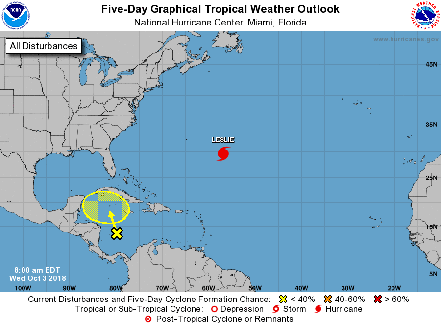
There is no real clarity in the models right now, but a lot of this moisture seems likely to get pulled northward over the next week, toward Florida or the northern Gulf of Mexico coast. There is little indication in the models that this will strengthen into a hurricane, nor does it seem likely to eventually move toward or into Texas.
You say “unending temperatures” as if it’s 90-100 outside. The one good thing (great thing, really) about all the cloud cover is that it’s keeping daytime temperatures hovering around 75. Which, in early October, when we’re often still in the “why won’t the 90+ with humidity END?” doldrums . . . I will cheerfully take. 😉
The high on Tuesday was 90 degrees at Bush IAH.
https://www.wrh.noaa.gov/zoa/getobext.php?sid=KIAH
While the recent days have been pretty hot, the late afternoons/early evenings have been approaching pleasant.
It was darn warm yesterday!
I wish it was 75! Not sure where you live but I was out side today and it was a hot humid 88 degrees.
Whew! Reading your post this morning has me feeling calmer for today..My local major TV weather station, (which broadcast a Facebook live at 8 pm last night) mentioned that the GPS and EURO were split for tracking..According to this weatherman, the Euro has this thing tracking closer to or in Florida, GPS had it tracking closer to us..
The impacts of global warming are seemingly being felt earlier and with more intensity than even the most pessimistic projections. I am starting to believe the modeling the that suggests that the gulf coast will, over time, become far less habitable and depopulate as a result.
Kip, I get what you are saying…I am beginning to regret having put down roots here, near Houston..The older I get, the more I’m thinking of moving far (at least 600-800 miles) inland from the Gulf Coast..While I love being able to drive to a beach that is 10 minutes from my house, I am tired of having my life turned upside down increasingly more often by hurricane evacuations / landfalls..
Probably more to do with ocean oscillation caused by solar cycles
I have a 10K on October 20th. Fingers crossed for some cooler drier air SOON
I’m in that one, too, and, yes, it’d be nice for some cooler and drier air for that!
At least I moved to Houston just in time for all the awful, abnormal weather!
I wonder if a “much later” cool front means it will cool down and stay cool? We do usually have something pass through by now that gets us all excited, only to be back in the 90s two days later. Any weather forecast I desperately search for the first “hint” shows it maybe — maybe — by the week of the 15th, but that’s too far out to be reasonable. I’m headed to Chicago this weekend. When I first looked at the forecast two weeks ago, daytime highs in the 50s; overnight lows in the 50s. Now, daytime highs in the 70s; overnight lows in the upper 50s. I’ll take it.
Yeah, I’ve about had enough of this humid, mosquito infested swamp of a city.
Amen! You also forgot to mention traffic and expanding urban blight.
Eric or Matt…any data analytics on whether this year’s weather pattern (in terms of tropic activity, temps, rain, etc.) is linked to last year’s activity? For example, in a heavy year of tropical activity, the following year is lighter?
I did some research on my own and I noticed a pattern between years with heavy tropic activity versus light activity following it. I did not research the reason though (el nino, etc..)
Curious if there is a pattern between hot/cold weather and wet/dry weather year after year.
When I think of Fall coming I imagine a dowloading screen…that stopped at 50% and taunts me.
I’ve held on to every mention of “8 to 10 days” since early Sept and I think I’m going to have to just crank the A/C down to 60°, bake pumpkin bread, put on a light sweater, and brew a pumpkin spiced latte. I may even rent a snow machine for outside so I can have a pretty view. You’re all welcome to join my indoor Fall festival.
Little known secret that I just made up.
Progress bars are actually built by random number generators.
I wore my tights and boots today…dressing for the weather I want!