Our weather pattern heading into the end of August and early September has definitely changed, as high pressure has shifted east, and opened up the Texas coast to moisture from the Gulf of Mexico. While we don’t see any tropical threats at this time, certainly we can expect to see some elevated rain chances and (for August) cooler temperatures for most of the rest of this week, and Labor Day weekend.
Tuesday
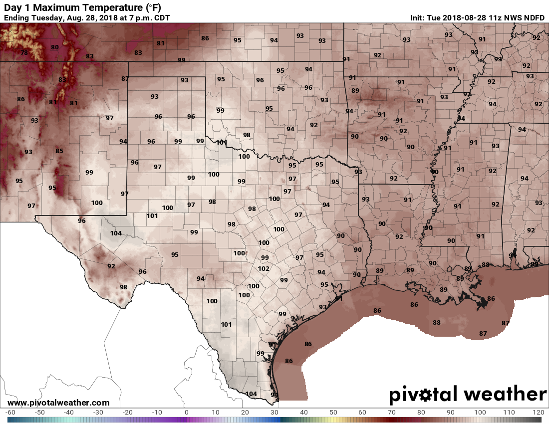
Temperatures today will depend upon cloud cover, likely ranging from about 90 degrees into the mid- or even upper 90s for far inland areas that see mostly sunshine. Overall rain chances will be pretty healthy, about 50 percent. In this pattern, one neighborhood may receive as much as half an inch, while the next neighborhood over gets some sprinkles, and the next neighborhood after that gets no rain at all. Flooding won’t be a concern, but the National Weather Service does warn that scattered showers and thunderstorms today may produce short-lived tropical funnels and waterspouts.
Wednesday, Thursday, and Friday
This pattern should more or less hold for the rest of the work week, with partly sunny days, scattered showers and thunderstorms, and high temperatures between 90 and 95 degrees. For the most part, outdoor activities should be fine, but if you do see a thunderstorm moving in you most definitely should take cover due to the potential for lightning.

Labor Day Weekend
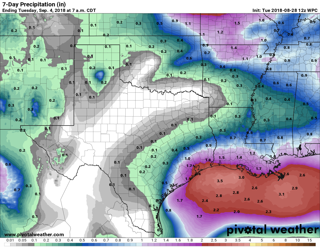
If anything, we expect moisture levels to rise this weekend, and open Houston up to even more rain chances. For now, we’ll keep the probability of rain at 50 percent, but we could definitely see them going higher. It would not surprise me if most of Houston picked up 1 inch of rain during the holiday weekend, with higher isolated totals. Sunday and Monday look more cloudy, and less sunny, than Saturday. We’ll try to refine the forecast a bit as we get closer to the weekend because I know a lot of people have outdoor plans.
First cold front?
I’ve been asked by several readers when the first “real” cold front may come, which we’ll define as an overnight low temperature in Houston of 65 degrees or lower. Typically this happens about the third week of September. The forecast models are hinting this may come in the neighborhood of Sept. 9-11 for Houston this year, but that is a long way off, and the signal is pretty tentative. So it’s something to hope for at this point, but probably not expect.
I saw a lot of chatter on yesterday’s post about Euro showing a Texas storm. What it was showing was a tropical depression or weak tropical storm. And this was at the 10 day timeframe.
Yes, the operational model shows “something.” This morning, it is a slightly stronger system making landfall on the Mississippi Delta. However, there appears to be no support in the Euro ensemble for this system. The GFS this morning also shows a weak system (probably a depression) making landfall in the middle Louisiana coast and quickly recurving away from Texas. It looks like there is a little more ensemble report for “something.” In either event, we are still the middle to end of next week.
Bottom line, even GFS is not showing a doomicane. At present, there is really no reason to worry about it. By the end of the week or into the weekend we should hopefully get a better handle on this “thing.” I have complete confidence in Eric and Matt to keep everyone informed of the facts around whatever may, or more likely, may not, happen.
“I saw a lot of chatter on yesterday’s post about Euro showing a Texas storm.”
I deleted all that crap. It was all the same person, posting comments under 6-7 different names, talking to himself (“Yeah! Listen to this guy! He sounds like he knows what he’s talking about!”) to keep the conversation going. It was hilarious and hilariously sad. Some people just aren’t happy unless they’re the center of attention.
Thank you for keeping the server up last year!
I see you’ve made some changes to the comment widget, as well. However, the login buttons aren’t working for me. Not sure if that is a client side issue or a server side one, though.
I toggled on Jetpack commenting, yeah—the WP.com and twitter buttons appear to function just fine. I can’t test the facebook one (I don’t have a facebook account). The google one, though, is acting funky. I’ll take a look this morning when I have a few.
edit – I think I see the problem. Need to adjust the site’s Content Security Policy and the X-Frame-Options header to get Google functioning. I’ll hit that in a bit.
edit^2 – Confirmed auth with all listed identity providers functions properly. Verified with Chrome 68, Safari 11.1, and Firefox 61, from multiple locations and on multiple test boxes. If you’re using something else, you’re on your own! 😀
Chrome 70 appears to be broken.
@jonathan, re: chrome 70: live on the bleeding edge, encounter bleeding edge problems. When Chrome 70 hits stable in October, that’s when I’ll care whether or not it works.
Oh I understand. Just letting you know.
Apologies sir, but I am not, and was not affiliated woth Sky Guy. I was just interested in what he had to say.
No worries at all—you weren’t one of the fake people skyguy was pretending to be 🙂
Weather Gurus:
Thoughts on the models that are putting a strong rainmaker (whether named or not) in Houston in about a 8-10 days? I know 10-day models are dangerous, but I also trust you’ll be honest without hyperbole.
I don’t know how to access precip forecasts for Euro, but GFS shows 2-3.5″ over the next 15 days. None of that is related to a tropical system. Over the last several runs, I’m not seeing a strong rainmaker.
“To end summer”?
I thought it was always summer around here………
Thankfully, it is! Clay
Jeff Lindner, the face of Harvey, has written about his experiences: https://abc13.com/society/jeff-lindner-8-days-that-changed-my-life/4076581/
Two sections really stood out. One, regarding one of the families to whom he donated his vacation money:
“It was one house in Kingwood that had flooded with about 6 feet of water and had never flooded before. I remember walking up to the door and noticing neatly stacked novels on the front porch that had been clearly flooded and were beyond repair. After talking with the individual for a few minutes I asked about the stacks of books, probably about 150. She paused for a moment, clearly upset, and said those novels I have collected all my life and each one is autographed by the author and I just cannot bring myself to throw them away. It is the horrible realization of the loss of what can never be replaced that in many cases was so tragic.”
And the other:
“Of the eight straight days I worked Harvey from the Emergency Operations Center, it was not until Friday, September 1, that I would fully realize just how widespread and devastating the event truly was. That moment came while having a conversation with a FEMA representative who had arrived from Washington. I remember asking him how he thought Harvey would compare to Katrina. His reply was, “I think this is about as bad as Katrina.” He went on to elaborate, how for the last five days the nation had watched the disaster of Harvey unfold, nearly the same as I remember watching the devastation of Katrina each evening. When working from that Saturday night to Wednesday, I knew Harvey was really bad, historic, but never did I ever think we were at the level or even near the level of Katrina.”
The sunsets are noticeably earlier and the sun angle and longer shadows. Football is on and pumpkin everything in the stores. Cool air is not to far away!
Considering this is Houston and it’s a holiday, shouldn’t we be expecting like 10-12 inches of rain on Labor Day?