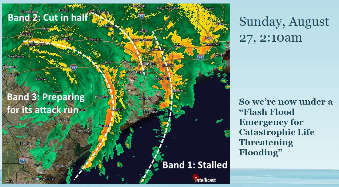
I can remember this morning, from a year ago, with crystal clarity. The Houston region had just seen its most intense night of rainfall, ever, as three major bands of rainfall swept across the city and flooded everything. Conditions grew so dire that the National Weather Service essentially invented a new warning to characterize flooding across the region, declaring a “Flash Flood Emergency for Catastrophic Life Threatening Flooding.” And it had only just begun, with the Houston region facing three more days of heavy rainfall.
On this anniversary of Harvey, I invite you to share your memories with the Harvey Memories Project, a partnership between Rice University and local libraries. The goal is to create a digital archive of photos, short video, and audio of Harvey experiences. Local health researchers are also collecting information about the health, housing, and vehicle damage from Hurricane Harvey, and you’re encouraged to participate in this survey. Now, onto the forecast.
Monday and Tuesday
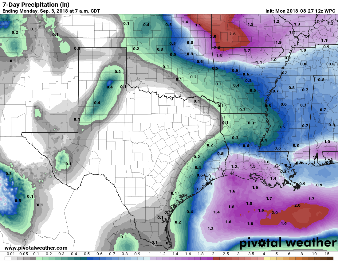
We’re in the midst of a pattern shift, as the high pressure that dominated Houston’s weather last week moves away from the region. This will lead to better rain chances this week, although perhaps not right away. Rain accumulations will generally be better for central and coastal parts of the region, rather than areas to the northwest, but overall most people should pick up some much needed precipitation this week.
For Monday and Tuesday, we’re probably going to seen only isolated to scattered rain chances, with 20 to 30 percent of the area seeing showers. High temperatures will depend on the extent of localized cloud cover, but probably will range from about 90 degrees to the upper-90s for areas that see full sunshine.

Wednesday through Sunday
The forecast for the rest of the week will see elevated rain chances, with a 30 to 50 percent possibility for the region to see precipitation on any given day. Overall, we’re not concerned about the potential for flooding, as accumulations should range from about 0.5 to 1.5 inches of rain this week, which frankly most of the area needs. High temperatures will depend upon local rainfall, but probably will range between 90 and 95 degrees.
Tropics
Matt wrote Friday about the potential for increased tropical activity about 10 days from now in the Gulf of Mexico, and we’re still seeing a signal in the forecast models for something to get going later next week. There remains relatively little support for development of something like a hurricane, but it does seem plausible that we’ll see elevated levels of tropical moisture in the Gulf. We want to stress that there is no specific threat right now that should concern you, but rather that as we get into the heart of hurricane season you may see some more chatter about the Gulf heating up. We’re watching it closely, and will let you know when there is anything you need to be concerned about.
Any of the long range models suggest when Houston may see its first real cool front yet? Understanding of course that predictions that far out are not that reliable.
I believe that history shows us the first decent cold front of the season happens between the tail end of August and the first 2-3 weeks of September. This usually correlates with the end of our hurricane season, though there may certainly be outliers.
A handful of the ensembles are suggesting we may see a front around the Sept. 10 timeframe. For now, very low confidence in that.
Many models I have looked at have it hitting Louisiana instead. Even then, it is a relatively small system. There is however, a rather large system in the pacific.
I will ask here in the event Eric or Matt is able to answer. Google and asking on Twitter have failed me. Is there a place to read archives of nwschat? I know about the iembot at Iowa State (I did not know about itduring Harvey), but it appears to show only recent posts. I’ve seen a few snippets from Saturday night/Sunday morning (such as Lindner stating the Willow Waterhole had flooded), but I want to read through the full thing.
I do not know of an archive of NWS Chat.
Thank you.
One year ago today was SCW’s biggest traffic day ever—1.1 million page views to 570,000 visitors. Traffic graph looks like this. (To put this in perspective, it’s about 100x the average daily load of the site.)
I tried not to be a pest to Eric throughout the day since he was dealing with very real problems, but as the numbers spiked I started to get more and more worried. Yet, even after SCW got a few mentions on CNN and other news channels and the traffic storm intensified, the server stayed rock steady.
Keeping track of how the site was doing on the backend became a touchstone to me—I couldn’t do anything about the rain, but I could make sure the server stayed up. It was the one thing I could do to help, and monitoring the SCW web server and making sure it was working without a hiccup probably kept me sane during those endless hours.
If you guys are interested in learning more about the SCW back-end and how the server side of things around here are set up, I wrote up a big piece on Ars Technica describing Spacecityweather’s hosting situation and how the site reacted under massive load. It’s a little technical, but I kept it as accessible as possible for folks who don’t have a system administration background but are curious about how a site like SCW works.
(Edit: thanks for the kind words, everybody!)
I enjoyed this. Thanks!
Thanks for all you do, Lee!
Without Lee this site would have crashed HARD.
So I held it together reading Eric’s post, but now Lee’s comment has made me cry. I think because it is how we all felt – we had to find our one little thing to help our neighbors and stay sane. Thanks for all you both do.
Great read, I’m also into DevOps/Development/Large scale applications. My suggestion depending on your backend design. Auto-scaling groups on AWS with thresholds set. Or ECS workloads. If you want to chat offline, let me know.
On one hand, SCW’s workload is both very cache-friendly (we’re primarily serving the front page and the latest article) and very CDN-friendly; we could run the site on an AWS micro instance for 99% of the time, since cloudflare does a lot of the work and Varnish does most of the rest.
That being said, a single physical colo’d server simply isn’t that expensive and a cloud-based scaling solution has considerably more management overhead. All things being equal, my choice has been to avoid screwing around with cloud-based scaling solutions because for SCW, they’re more trouble than they’re worth.
A single physical server w/nearline & offline backups, located in a tier 1 data center in a different (non-hurricane-prone!) geo is, IMO, the right solution for SCW right now. The TCO is easily forecast-able and low, rather than varying based on traffic, and it’s easy to build a DR plan w/ an RPO & RTO I find acceptable. AWS is attractive for other use cases, but I don’t believe this is one—at least not right now.
Hi Eric, seemingly random question but since we are reminiscing about Harvey it seems pertinent. We found our dream home, but it appears to have only flooded during Harvey. I know you aren’t in real estate, but would that deter you from such a property? Ie, the chances of something like Harvey happening again?
It would be ill advised for anyone to provide a recommendation on a purchase, with only knowing the property flooded once from Harvey. There many factors that contribute to flooding, besides a Harvey event (though Harvey – and Allison – are at the top). You’d best, as a start, study the FEMA maps for where the property is located. Also, check out the Harris County Flood Control District’s web page – especially their FAQ page: https://www.hcfcd.org/faqs/
I would also check all new developments since Harvey and potential developments. That is what flooded our neighborhood. Our neighborhood has been standing since late 70’s and only flooded in Tax Day (several homes) Harvey (all homes) due to two new subdivisions that contributed to the watershed’s overflow. Unfortunately Harris County does not care and will issue building permits without considering the flood potential of existing well-established areas…perfect example is building within the Flood Way near Beltway and Memorial (for one)… (who builds IN a water way????)
Gentleman,
It definitely felt a dash cooler this morning when I walked outside but that may be the pattern shift you noted. When will we see a noticeable tick down towards cooler weather and truly enter into fall?
Seeing Jared and Jonathan’s comments prompted me to look at the IAH Climate Data chart…Holy Cow, sorry I missed the really neat front that passed through the area in ???? in which the record lows for August 24 – 27 were 54, 55, 57 and 59…guess I better stage my favorite sweater?!
I would be interested in knowing if that immediately followed a hurricane landfall in the area. There’s a bit of chicken and egg thing here, but there are instances where a hurricane landfall is followed by the arrival of the first good cold front of the season. Ike is one recent example of this. But does the hurricane pull the front in or does the front pull the hurricane in?
Today marks my 1 year anniversary on this site. Matt and Eric, you guys gave me facts (as harsh as they were) while the rest of the media channels were hyping coverage. My heartfelt gratitude for that. That was an insane week that I hope I never see again (we had to be evacuated from our driveway by a boat after lots of other drama!) but to see how random strangers came together to support each other and people selflessly help others regardless of color, background, political views, etc was so heartening and makes me proud to be a Houstonian (by choice, not birth).
I’ve been an avid reader of SCW since and have recommended your site to countless others. Please keep up your great work. And thanks to Lee as well for keeping the servers up inspite of a 100x load increase.
Yes, this has been my source for weather ever since Harvey. No frills, just facts.
If there is something I remember from following the Space city weather site on August 27 2017, was Eric’s serious and heart rendering posts on things going from bad to worse. I was not in the same place to see his face but i could picture it from his words. A mix of frustration for not being able to give his fellow Houstonians a better message of hope, since he has learned to call data as they are, without sugarcoating. This is why I follow the site.
Aren’t you the same person that tried to scare everyone during July 4th with the worst flood in history?
Gotcha. Well I’ll keep an eye out thanks (Moves to Alaska)
He’s also talking to himself. All posts from “Sky Guy,” “David M. Langham,” “Ryan,” “Nortenathe,” “Paul Robison,” and lots of other names (I quit counting) are all the same person.
That’s hilariously sad, man.