Houston remains in a wetter, slightly cooler pattern that will see up-and-down rain chances through the Labor Day weekend. As we near the heart of hurricane season we’re continuing to expect activity to ramp up in the tropics, including possibly the Gulf of Mexico, but see no specific threats at this time. We’ll discuss that a bit more below.
Wednesday
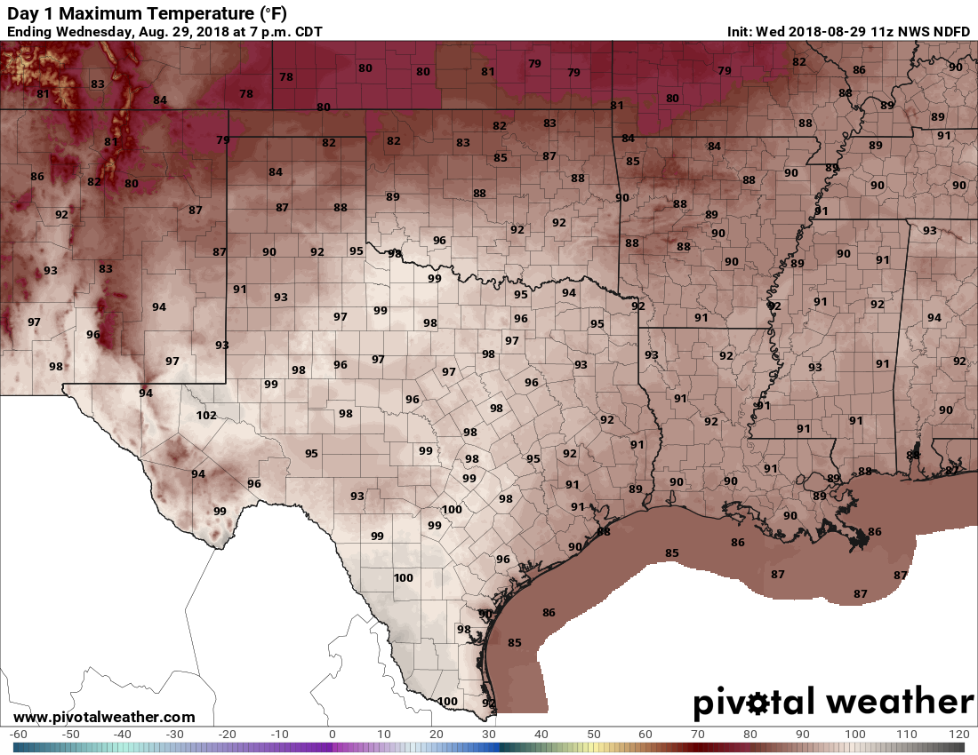
Lower pressure draped over the region today, combined with moisture from the Gulf of Mexico, should induce some pretty healthy rain chances for Houston (probably around 50 percent), especially during the afternoon hours. Because of some unstable air, where thunderstorms form, they could become severe, bringing the threat of strong wind gusts and lots of lightning. Some slow moving thunderstorms could quickly dump and inch of rain, or so. Highs will depend upon localized conditions, and should vary from the upper-80s to mid-90s.
Thursday and Friday
Rain chances fall back a bit, especially for inland areas. I still think coastal counties and the southern half of Harris County will see 40 or 50 percent rain chances, but they will be lower for other areas. Partly sunny skies should allow high temperatures for most areas to push into the mid-90s.

Labor Day Weekend, and early next week
The pendulum swings back toward scattered to widespread showers over the Labor Day Weekend holiday, and first half of next week. These days will be partly sunny, but also see building clouds during the afternoon and evening hours that will bring intermittent showers and thunderstorms through the region. We don’t have any significant flooding concerns right now, but each day carries about a 50 percent chance of rain. So if you’re at the beach or having a backyard BBQ, make sure and have a contingency plan to duck inside during any lightning or downpours. Highs will likely stay in the low 90s.
The tropics
Matt and I have been tracking the tropics closely, and the global models continue to indicate the possibility of “something” tropical developing in the Gulf of Mexico next week. There’s probably about a 50-50 chance of that. Most likely, whatever develops, will be some kind of rain-making swirl of tropical moisture, although we certainly can’t rule out a tropical storm or hurricane at this time of year. Expect other, more powerful storms to develop far out in the Atlantic over the next 10 days, likely with less of an impact on the Gulf of Mexico.
As soon as we can say something more educated about the tropics, we will. As ever, during August and most of September, we must remain watchful.
Thanks Eric. We appreciate your forthright honesty. We’ll keep our eyes peeled through the weekend. Looks and sounds like we’ll know by Monday whether this is something about which we need to be concerned.
If Harvey taught us anything, it is that a stalled low pressure rain maker can have devastating effect on the Houston area and that tropical storms on up aren’t the only danger.
Thanks for the heads up. I’ll be paying close attention to your reports.
The NHC is eyeing a system in the eastern Atlantic. Only a thirty percent chance of development right now. Is this the thing that would be a threat to the gulf, or is it separate? Thoughts?
Completely separate and very (very) likely not a threat to the Gulf.
But then where will t go? There’s a high pressure ridge that looks like it will keep that system headed on a straight line for the gulf?
On a completely separate note, I also see a system that looks like it will hit Alabama. Is that also separate from the one that will hit Houston? I’m very confused
From what I’ve seen, the system is the far Atlantic should be a fish storm. That is, one that stays out to sea.
A couple of rules of thumb (but every storm is different):
The further east something forms, the greater the chance that it recurves before threatening at least the US; however, the further south it forms, the further west it has a chance to go.
Stronger (deeper) storms are steered by higher layers of the atmosphere, and they will typically find weaknesses in ridges that are not evident in the lower levels. Therefore, stronger storms typically turn north sooner. Two major exceptions to this were Betsy in 1965 and Ike. Both were major hurricanes that looked like they were going to recurve off the east coast but then got pushed southwest and into the Gulf.
Whatever you saw about Alabama, provided it was in the back half of next week, is probably the “thing” Eric mentioned.
Thank you so much!!
Eric, you guys are SO sharp, I’m not sure why we need anyone else in this area!!
Thank you both!!