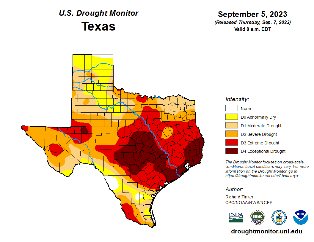
The region’s drought has steadily worsened this summer, with unrelenting heat and only very isolated to scattered rain showers in July and August. At the start of summer there were virtually no dry or drought conditions anywhere near the greater Houston region. Now half of the area is is an exceptional drought, and the other area is in an extreme drought. (They’re both bad, but exceptional is worse).
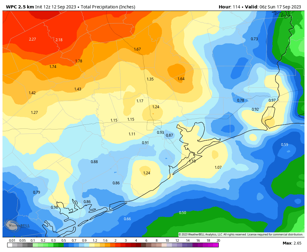
While the rains we’re going to receive in the next several days aren’t going to break the drought, they can at least start to put a dent in it. And psychologically, for a lot of us, they’re going to feel oh so good. Beginning Wednesday, and persisting through Saturday, we’re going to see daily rain chances on the order of 40 to 60 percent as a disturbed pattern stalls overhead and helps to generate lift in the atmosphere. Most of the area probably will see, on average, 1 inch of rainfall, but there will be a wide variance in totals. Daytime highs will be cooler with the rainfall.
Tuesday
It probably won’t rain today. Oh, there’s perhaps a 15 percent chance of showers this evening, but for the most part we’re going to be sunny and hot, with highs in the upper 90s. A few far inland areas may touch 100 degrees. Skies will be partly to mostly sunny, with only very light winds. Slight rain chances will continue tonight, with lows in the upper 70s.
Wednesday
This will be another partly to mostly sunny day, but highs are likely to top out in the mid-90s. Rain chances on Wednesday afternoon and evening are probably on the order of 30 to 40 percent. Some stronger thunderstorms will be possible, but for the most part these showers should be fairly light.
Thursday and Friday
These two days will likely carry the best potential for rain, with a healthy 60 percent chance each day. With partly to possibly even mostly cloudy skies, highs likely will top out in the low 90s. (Some locations may actually top out in the upper 80s, if you can believe that). Afternoons will be the most favored time period for showers and thunderstorms, although they will be possible overnight as well.
Saturday and Sunday
The first half of the weekend will offer one more healthy chance of rainfall, with highs in the low 90s. After this time a weak front will be moving toward the area, and this should bring slightly drier air and mostly end the potential for rainfall. So we should be back to mostly sunny skies on Sunday, with highs in the low- to mid-90s. Nighttime temperatures to start next week should be a bit cooler with the drier air. I’ll go with lows around 70 degrees in Houston, but there is definitely some wiggle room to go a little bit cooler or a little bit warmer.
Next week
I’d love to tell you that we’re going to slip even further into fall next week, but it looks like Houston will fall on the periphery of another high pressure system, and this is likely to bump our high temperatures back into the mid-90s for awhile. The worst of summer is over, but alas, summer is not over.


“There comes a day each September when you wake up and know the summer is over and fall has arrived. The slant of the sun looks different and something is in the air–a coolness, a hint of frosty mornings to follow.” ― Ann Rinaldi
I am not sure that the day has arrived when we know summer is over just quite yet and fall is here. But the day has arrived when we know the summer from hell is over…
There is just something about that first truly cool morning (yesterday up here in The Woodlands/Conroe) that just makes me happy. I know that we still have hot days ahead, but the mornings will begin to be more pleasant as the days go by. I look forward to coffee on my patio enjoying the cool mornings.
The spine of summer has not, yet, been broken.
I’ll believe the rain when I see it.
And this is why I agree with Matt in that September is the worst here, as the promise of Fall is in the air, but when you open your door with a light cardigan on and it’s still 95, well.
“September is the cruelest month, breeding thunderclouds from the dead sky…”
The promise of fall is much better than the despair of August when autumn is still months away…
I don’t know, man. The tease is pretty bad.
There are some who like being teased…
I’ve been able to go on jogs without my chest hurting from the heat. That was something I couldn’t say in August. August is worse.
The dominance of that SW ridge is the problem….. July, August rain was normally around 4” per month in the 30 years prior to 2020. For me, it is not the heat – it’s the dry. And that ridge is moving back east next week, centered over south Texas, after Lee goes by, 9 days from now per GFS. 5910+ meters height just as before. Once we’re faced enough north of the ecliptic during the day, it has to disappear. But will it return next May is my question. Thoughts from the peanut gallery please.
It will likely return next summer as well just hopefully it doesn’t stall over the same area for so long next summer. We normally see that upper level high pressure ridge sit over Texas and the the SW at times throughout the summer but not normally through the whole season with the exception of a few bad summers of the past. Luckily looking back in history we don’t usually get 2 summers in a row like this. Hopefully that stays true next year.
Ok Joseph. I never paid attention to the ridge before so I don’t know how it has moved or dissipated in past summers. What else was going on. We’ll see.
Summer is the best time of year.
Hahaha that’s why it’s the “peanut gallery”, the cheap seats (?), the “maven of weather experts”… What should I call this collection of comments on the blog that I enjoy reading daily.
Can we leave it open on the weekends too? Or I guess it needs monitoring.
I am a proud member of the peanut gallery. I wouldn’t call myself an expert, but I would say that I’m more of a weather amateur. That’s what we can call it. ” The Maven of Weather Amateurs lol
I’m at the end of my rope with this heat. Looks like Fall Day is going to be in October this year… This is my last Summer here and it sure was awful. Saving to move back East.
I give all Houstonians credit for dealing with such long/brutal weather! I couldn’t do it! My daughter and family are in Houston and I have mentioned several times in the past few weeks to come up to Rhode Island where it has been in the 70’s/low 80’s….ahhhhh….apple crisp weather……
My wife swapped out our dish soap for the fall pumpkin spice variety. Didn’t know dish soap could make me so upset.
Exactly how much rain is needed to end the drought or, more specifically, the watering restrictions? What is the threshold that determines when the city moves into stage 3?
Five. We need five rain.
I would really like to know, is this the future of our summers from now on? And what about the crazy winters as well? I was born in Houston and lived here for 66 years. When I was younger I guess I didn’t pay much attention to what the weather was doing, but I don’t remember my family going through these issues. Is this what’s in store for us from now on?
We have always had crazy extreme weather events in this area but they are happening a little more often these past few years. Houston had a really bad ice storm in late January 1951 which brought a record low of 14. There was also the terrible drought that struck Texas in the 50s as well. We had Carla in 1961 which tore Matagorda and Brazoria county to shreds. Soon after this another harsh freeze hit in January 1962. This was followed by an intense heatwave and drought in the summer of 1962. We also had the torrid Summer of 1980 and hurricane Alicia in 1983. A freak freeze hit in Feburary 1989 which brought temperatures below freezing for 4 days in a row. Another freak freeze brought single digit temperatures to this area on December 23rd 1989. There are alot more I didn’t mention just for the sake of time, however the point is that we have always had crazy weather anomalies but depending on how people were affected by any given event will determine if they remember it or not years down the road.
Also Summers are getting hotter on average than they used to decades ago. You are correct by noticing that. We always had our intense heatwaves but it does seem to be happening more often especially since the 2010s. I fear the summers in this area will continue to get worse on average over the next few decades. It doesn’t mean every summer will be like this one. We still will get rainy and cooler summers like 2021 from time to time but hell summers like this one will likely happen more often unfortunately. Hopefully I’m wrong on that.