August may be over, but the heat will remain for Houston as a late-summer ridge of high pressure settles in over the region. There are no cold fronts in sight, alas. Meanwhile, the Atlantic season’s fifth tropical storm is forming in the southern Gulf of Mexico (it is no threat to Houston) and Hurricane Dorian has absolutely ravaged the northern Bahamas. We’ve got a lot to get to today.
Monday
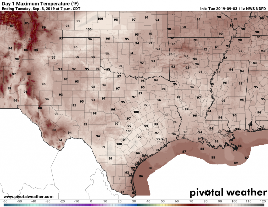
There are no bones about it, today and the rest of the week will be hot beneath a ridge of high pressure. Coastal counties, such as Galveston and Brazoria, may see some showers today from the very outer bands of the tropical system deep in the Southern Gulf of Mexico, but most of the region will be hot and sunny, with highs near 100 degrees. Lows tonight will be near 80.

Tuesday through the weekend
To be honest, the weather is not going to change a whole lot for Houston this week. We’re going to remain in this high-pressure driven hot-and-sunny pattern, with highs near or at 100 degrees for the remainder of this week, and likely through the weekend. Rain chances will be near zero, as we start to have some drought concerns.
Heat, how long?
The heat wave may finally break early next week, as highs fall back to more normal temperatures in the low- to mid-90s. However, the chances of a cold front during the first half of September appear to be quite remote.

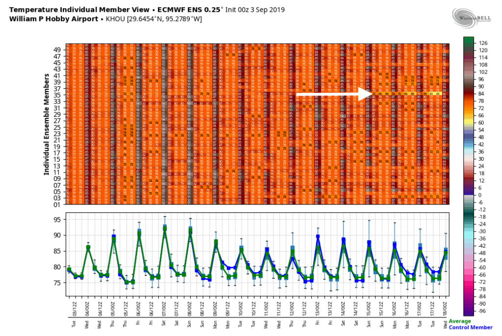
Here’s the latest ensemble output from the European model for low temperatures through September 17. Just one member out of 50 (!) brings a notable front into Houston during that time. These are not, uhhh, good odds.
Tropics
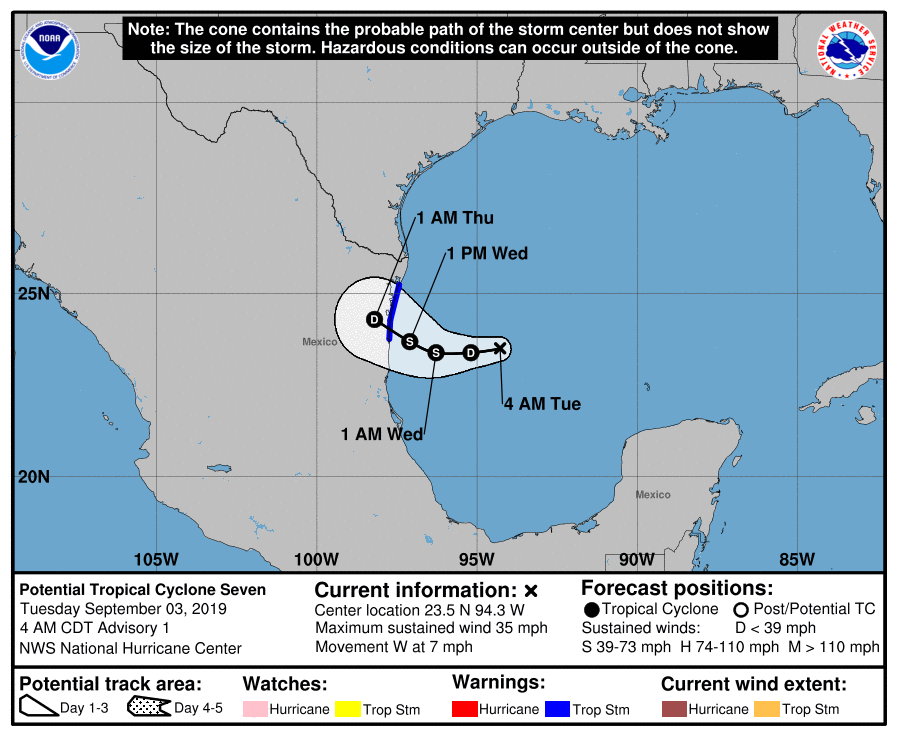
Let’s start with the system in the southern Gulf of Mexico, which is likely to become a tropical depression today. Matt and I have not paid this system much attention over the last several days because it has been clear that building high pressure over Texas is going to steer it away, and that is indeed what is happening. The Brownsville area may see some rain bands and winds today.

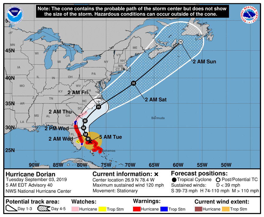
Meanwhile, in the Atlantic Ocean, Hurricane Dorian has absolutely ravaged the northern Bahamas this weekend after becoming nearly stationary for a day and a half. Finally, today, a trough of low pressure moving southeastward over the United States will pick up Dorian, and should begin to pull it north. This should keep the center of Dorian away from the Florida coast, but its track could bring the storm very close to the Carolinas by late Thursday or early Friday.

Finally, the tropics remain quite active. While Texas only has a few more weeks of prime time season left, we need to remain pretty vigilant. The forecast models indicate development of a couple more vigorous tropical waves in the next week to 10 days in the central Atlantic, which may track westward toward the Caribbean Sea. It is most definitely that time of year.
Sponsor message
With the tropics heating up and Hurricane Dorian causing concerns for the southeastern United States, Reliant wants to help Houstonians be prepared and informed going into the height of hurricane season. As many homeowners plan ahead and consider different backup power options in case of emergency, Reliant is here to help. Here are a few ways you can get ahead of any storms that may impact the Houston area this year:
Generators
- A permanently installed generator can switch on within seconds of a power outage, ensuring your home stays powered during a storm.
- Reliant gives you access to industry-leading backup generators from Generac and KOHLER. The first step is to schedule a free personalized home generator assessment, which will ensure your home can accommodate a generator and determine the right product for your home, needs and budget.
- Reliant has extended an offer on generators through December 31:
— 10 percent off, up to $1,000, for a professionally installed generator
— 10-year warranty on Generac purchase
— Additional one-year free maintenance package
Portable Backup Power Solutions
- Having power at the ready is a necessity, but installing a permanent generator isn’t the only option for backup power.
- From power banks and flashlights to portable power stations and solar panels, count on Reliant’s sister company Goal Zero to help you stay powered when you need it most.
- Click here for a variety of products to keep you and your family safe, charged and connected at home and on-the-go.
- Check out Eric’s personal review of the Goal Zero Yeti 1000 Portable Power Station, which can even be connected to your home to keep up to four essential circuits running with the Yeti Home Integration Kit.
- Note that Reliant customers receive a 15 percent discount on Goal Zero products with code “RELIANT15”.
Reliant Storm Center
- Reliant is also by your side with their Storm Center site: http://www.reliantstormcenter.com/
- The site provides resources for before, during and after a storm, including preparedness checklists and evacuation routes, weather and power outage updates, flood maps, safety tips and more.

I’m guessing you mean September 17, instead of August 17.
When Harvey stalled over us at least we didn’t have days of hurricane force winds.
It weakened into a TS by then and was all about the rain.
The Gulf SSTs are bathtub temperature,,,let’s all remain vigilant…
Am I right assuming as long as we are sizzling under the ridge of high pressure hurricanes won’t come into our area but rather go around it?
I’m assuming that this didn’t mean to start out with Monday, because Monday was yesterday.
It’s too bad that tropical moisture is missing us, my lawn could definitely use it.
I agree, although I have to be careful what I wish for cause I also flooded during Harvey, but a little tropical wave or depression that doesn’t stall can actually be very beneficial sometimes, especially when it’s been this hot and dry.
One thing that has been missing from the talk about Dorian is how tightly wound it is. While the winds are positively awful and the eye is super intense, those crazy winds extend only extend about 40 miles out from the center. There are part of the “The Bahamas” that are doing just fine.
I’m jonesing for some cooler weather! 🙁
When do you think we will be out of the 90’s?
December