Good morning. Our region has enjoyed a few days with modestly drier air, but unfortunately that party is coming to an end today. We’re headed back into the mid-90s for the rest of the week, with ample sunshine and humidity. This pattern will change late in the weekend as as weak front approaches the area and likely stalls out, increasing rain chances and bringing some slightly cooler temperatures to start next week.
Wednesday
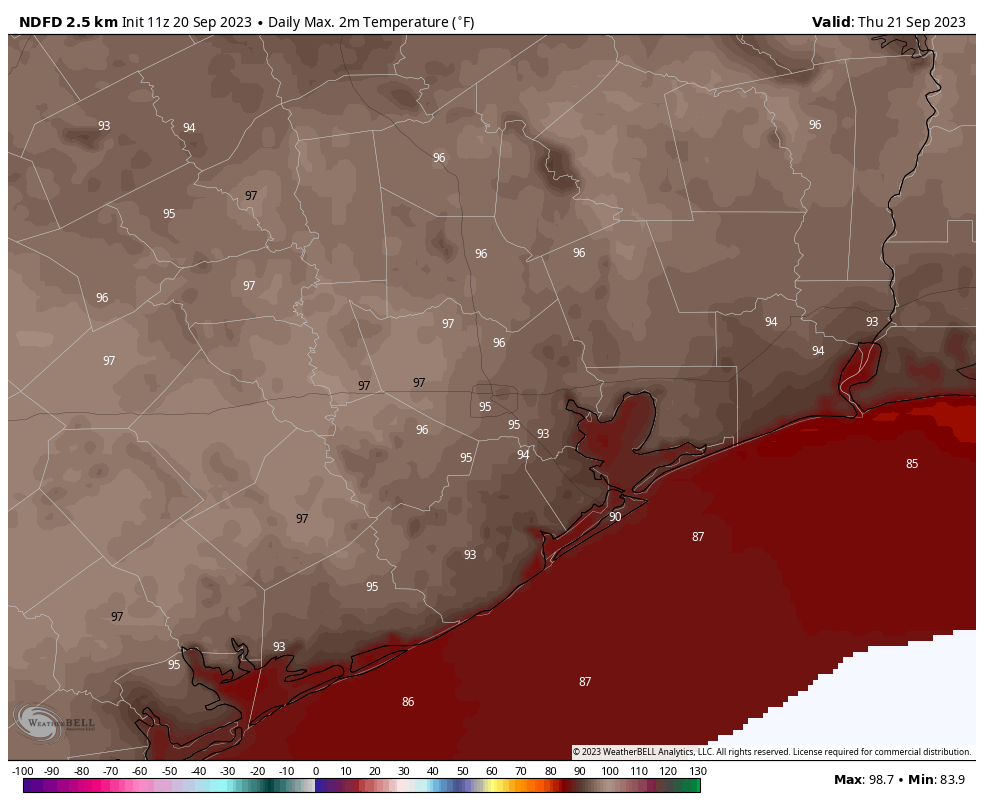
Our overall air mass remains slightly drier than normal this morning, but that will change as the onshore flow really kicks into gear today. This will bump up dewpoints into the 70s, and my friends let me tell you, that is Houston humid. Despite the increasing levels of moisture in the atmosphere, our skies should remain mostly sunny today as highs top out in the mid-90s for most of the region away from the coast. Winds will come from the southeast at 10 to 15 mph. Rain chances are essentially zero.
Thursday and Friday
We’re going to remain warm and humid, with highs generally in the mid-90s. A few far-inland locations may even ‘luck’ into the upper 90s. But there is something of a limit on how hot our temperatures can get this year, due to day length and solar angle. At the height of summer, the Sun reached an altitude of 84 degrees above Houston (the zenith, recall, is 90 degrees). At this time of year the solar angle is 60 degrees. It’s still going to be hot, though. We’ll also see some isolated showers, with perhaps a 20 percent chance of rain each day. Lows are going to be fairly sultry, only briefly dropping into the 70s.
Saturday and Sunday
The weekend will bring more of the same, with highs in the mid-90s, mostly. Rain chances each day will be on the order of 20 to 30 percent, with sunny skies. Nights will be warm. The aforementioned front is going to be dragging down toward the region later on Sunday, but right now I don’t think it will have too much of an effect on the weekend forecast.
Next week
The arrival of the front should increase cloud cover and rain chances to start next week. There are still a lot of details I’m not particularly confident in, such as the strength of the front, where it will stall out, and precisely how long it is going to hang around. But the bottom line is that we should see some slightly cooler days, with highs in the low 90s, and fairly healthy rain chances through the first half of next week. If I’m ballparking things, I’d set expectations at 0.5 to 1 inch of rain, but that’s kind of a hand-waving guess at this point.


So, in brief – continued yucky, just not as yucky.
…perfect summary!
That SW mid level ridge (500 mb level) won’t go away. Per GFS model it fades west next week and then returns back here in the first week of October. I’ve been tracking model vs actual for 9 days out and it’s pretty good. I agree with others in the peanut gallery- it seems no drought relief until well into autumn. I’m not familiar with this pattern. Other views from the weather mavens are certainly welcome.
Unfortunately some years the stubborn 500mb ridge can persist over Texas well into early and mid October keeping it mostly warm and dry here. Typically during an El Nino fall, we have a few upper level troughs of low pressures stall over Texas which can bring us a lot of rain in October especially. Hopefully since we are supposedly in a moderate to strong El Nino, we will see this pattern of frequent stormy weather start to emerge this October or November once the polar jet stream continues to drift further south, but obviously the weather does not always obey expectations based off history.
A year I always like to bring up is 2004. It was a bit of a wacky one. I was 9 turning 10 and this was the year that awakened my passion for weather. We had an El Nino Fall that year, but we experienced the warmest October on record still to this day. However, we recieved a ton of rain during the first half of the month thanks to a couple of low pressures and stalled out fronts. Then the upper level ridge built back in on the 16th and prevented any cool fronts from moving back over SE Texas for the rest of the month. The following November ended up being one of the wettest on record for this region. This ultimately led to us seeing that miracle white Christmas with nearly a foot of snow falling over the coastal counties. We usually see something interesting during an El Nino event, which is why I always get excited when they say El Nino is building.
Good stuff. You have plenty of years then to pursue your passion. I enjoy reading Batiste’s reports at NWS Houston. We need more long time pattern watchers – “this is what’s happened before and this how it ended” kind of thing. I guess we’ll just have to wait for the 1st cold front sometime mid October to change the pattern.
Houston has been “rather hot” for the last 4-5 months.
Eric, is September going to be a record heat wise? What will it take to break this awful ridge?
If we don’t see any significant cool fronts break through before the end of the month, than this will probably be the warmest September on record. The current mean temperature at Bush Airport for this month is 85.7. That is already well above the previous record hot September. Well above average temperatures are expected to continue over the next 10 days. So, it looks like this will be the hottest September at Bush Airport anyways. The changing of the season will eventually be the downfall of this stubborn upper level heat ridge. The northern hemisphere will shift further from the sun more in the following weeks, which will reduce the amount of energy we recieve from the sun. This will inevitably cause the upper ridge to weaken and shift further to the south finally opening the door for much cooler air from the north to spill in through Texas. It won’t be to long before we will start needing our jackets again.
Well, yesterday morning was nice…
We only got a few tenths of rain out of the last system so I was watering the grass this morning but it was very nice not being a completely sweaty mess when finished
Bleh, already 90F at 11AM out on the far west side, likely hitting the upper 90s this afternoon.
SSDD
96 degrees for my 60+ mile ride today along the bayou/reservoir trails, it is absurd that we should be getting these kind of temperatures the latter half of September. I’d file a complaint but I suspect no one will be listening – or even care. -:(