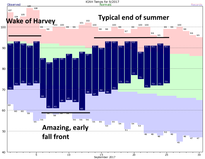
This September started out with some great weather. In the aftermath of Harvey, the region saw drier winds on the back side of the storm, and then, just six days into the month, we received a surprisingly strong early front. Usually the first front washes out in a couple of days, but this one stuck around for nearly a week. Since then, it’s basically been typical end-of-summer weather for Houston.
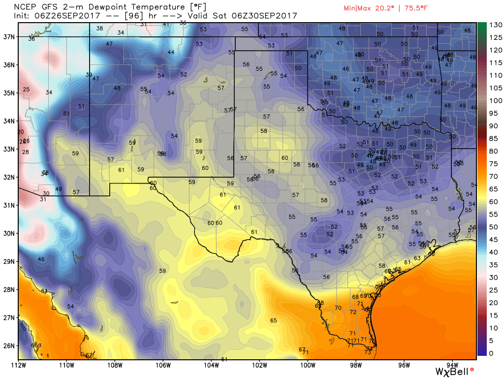
Now we’re about to get the second “front” of the season, but unfortunately this one is going to be weaker than the first. Indeed, this front is more like what we typically experience as the season’s first fall front, which more often brings dry air and slightly cooler weather.
Tuesday and Wednesday
Did you like Monday’s weather? Because the greater Houston region can expect more of the same today and Wednesday. While central and southwestern Texas is pounded by some heavy rains, the greater Houston area should remain mostly dry. I certainly think we’ll see some scattered showers and thunderstorms, especially to the southwest of the Houston metro area—but none of these should present much of a flooding threat. Highs will remain warm, around 90 degrees, with ample humidity.

Thursday and Friday
A fairly weak cool front will arrive sometime on Thursday, but this isn’t a classic, barreling out of the northwest type front. Rather, we probably won’t see much effect from the front until Friday evening, when drier air filters into the area. Highs both Thursday and Friday should be around 90 degrees, with slight rain chances Thursday. Lows Friday night should slip into the upper 60s.
Saturday and Sunday
The weekend looks pretty nice. Again, unfortunately we’re not going to see too much cooling with this backdoor front (which means the drier air moves in from the northeast), but drier air should make for pleasant evenings and mornings. Look for highs in the mid- to upper-80s, and lows in the mid- to upper-60s. Rain chances are approximately zero.
Tropics
Hurricane Maria is weakening over cooler waters in the Atlantic Ocean. Closer to home there appear to be no threats to the Gulf of Mexico over the next week or so.
Really enjoy your forecast. Followed you through Harvey and continue to get my weather information through your site. Thank you, keep up the good work.
Hurry up October!
🤗
Best weather site in Houston – good weather or hurricanes, this is the place to go !!! Great job guys.
Eric –
Any long-range forecasts available for what is mistakenly called “winter” here?
I’m looking forward to seeing some snow for a change, didn’t even see it when I went up north last holidays. It was in the 60s.
http://www.cpc.ncep.noaa.gov/products/predictions/long_range/interactive/index.php
Here’s an interactive long-range forecast map from NOAA that you can switch between temperature and precipitation.
The last 2 winters have basically been non-existence. It’s looking like this one might be the same.
This is a great weather report. My husband’s family is from Norway, I am from PR and we moved to Houston 20 years ago. I had my first real winter this year in February, and I loved it. My Norwegian family can’t understand why I love the cold weather so much. 🙂
Who needs the Weather Channel when we have this site?
Thanks
Rick K.
Any thoughts on what the “winter” has in store for us? I don’t know if I can take another no-show winter. If this is another bust of winter my home is going on the market.
I’m with you, JD. At least get me to Tennessee where it drops below freezing at night!