Good morning. Some isolated showers have moved into the Houston are this morning as a southerly flow returns from the Gulf of Mexico. Hopefully more of the area will see rain later today before high pressure settles in. Either way the heat and humidity is coming back for a good long while.
Today
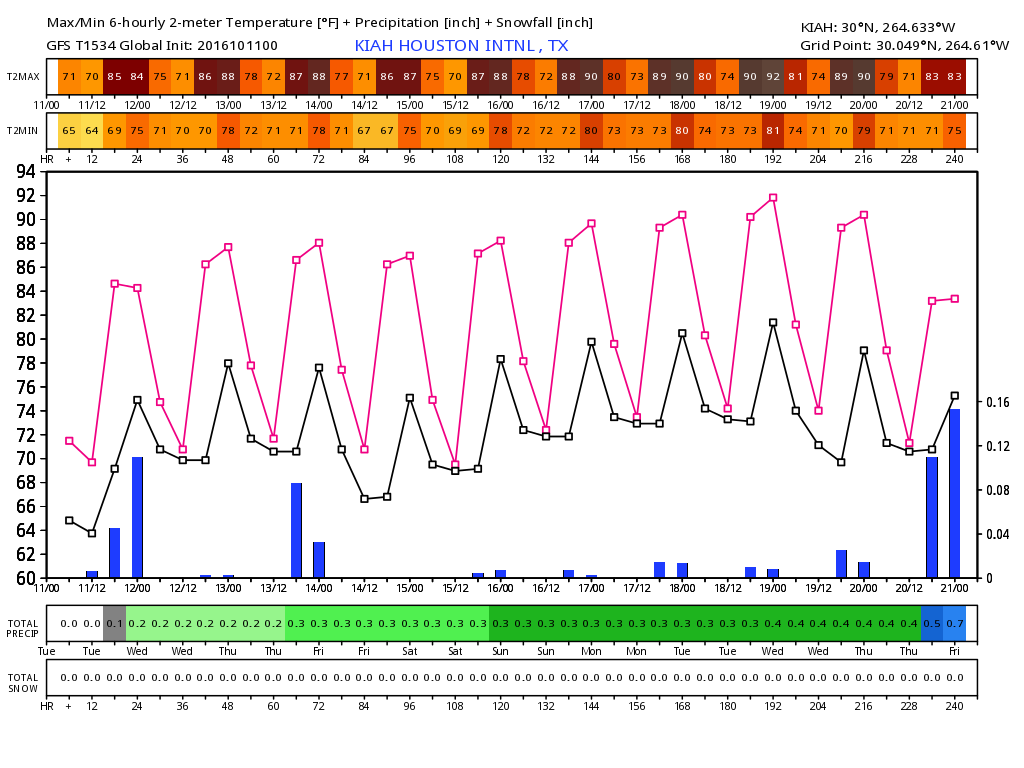
Some of the high-resolution models show pretty decent shower coverage later this morning and during the afternoon hours, as daytime heating develops. Some areas may receive as much as one half to one inch of rain today (others won’t see any, alas), and partly to mostly cloudy skies should limit high temperatures in the mid- to upper-80s. Lows tonight will be in the lower 70s.
Wednesday through Friday
After today we’re going to see higher pressures dominate Houston’s weather for the rest of the work week, and it’s not going to be fall-like at all. Days should be mostly sunny with highs in the upper 80s to possibly even 90 degrees. Overnight lows will be around 70 degrees north of Houston, and in the low 70s in the city and closer to the coast. We can’t rule out some storms on Friday as a cool front moves into northern Texas, but I don’t think the showers and thunderstorms associated with that front will make it all the way to Houston (the front itself won’t, unfortunately).
Saturday and Sunday
Rinse and repeat. While we can’t rule out some isolated showers and thunderstorms this weekend, it looks like mostly sunny skies and highs near 90 degrees will remain the order of the day. We agree with you, it’s a decidedly unpleasant pattern for mid-October.
Beyond
This stagnant, late-summer like pattern should continue well into next week, but both the GFS and European model continue to suggest we’ll see a cool front by around 10 days from now. And while we’d certainly be due one by then, it’s hard to have too much confidence in a model forecast that far out. Still, this can’t go on forever, can it? CAN IT?!?
Posted at 6:30am CT Tuesday by Eric
Thank you for your post. You are very spot on and do a better job than others in our area.
Eric,
I am hearing a lot of anecdotal talk from people saying that we used to (up until about 10yrs ago) always get one strong cold front before the end of October. Is there any truth to that? I always remember October being fairly warm.
We usually get a couple of nice fronts in October, and we’ll almost certainly get one again this year.
So far this October is running a few degrees warmer than normal, but we’re really going to feel it during the next week or so.
As if things weren’t bad enough, Eric, Texans will have to watch for development in the Southwest Caribbean early next week. If the GFS is to be believed, it could be the biggest storm in that region since Carla. If that front you mentioned fails to make it through Houston……
I am not worried about hurricanes and Texas this fall, and neither should you be.
Enough “scattered” showers today to cause a lightning strike which created a power blip which nearly shut-down our plant……..
Hoping the cold front does show up on the 21st…….will make for great flying at Ellington on the 22nd and 23rd.
Do long term forecast models indicate whether or not Houston will get a “Winter” at all this year? I still have my old video from a few years back of a snowstorm in Upper Kirby.
We’ll get winter, but snow chances are always iffy. Historically the region at least sees some flurries about once every four years.