Good morning, and I hope you had a fine weekend. Houston will see three warm days before a more winter-like pattern returns to the region. That is not to say it will be blisteringly cold, but rather simply that we’ll see highs generally in the 60s, with lows in the 40s and 50s. We will also have a smattering of rain chances, but as of now there is nothing too significant on the horizon.
MLK Day
If you’re planning to attend one of the parades that mark today’s holiday, you can expect warm conditions, with high temperatures in the upper 70s and mostly cloudy skies. I cannot rule out a few very light showers this afternoon, but I don’t anticipate thunder or anything disruptive. Winds will be out of the south at about 10 mph, with gusts up to 20 mph. Low temperatures tonight will drop into the low 60s, except for far inland areas such as College Station, that may drop lower as a bit of drier air moves in from the northwest.
Tuesday
Some fog will be possible near the coast on Tuesday morning, but this will dissipate as temperatures warm up in the morning hours. This will be a partly sunny and warm day, with high temperatures reaching 80 degrees for much of the area away from the coast. Record high temperatures for several locations are definitely in play with a warm, southwesterly flow over the region. Low temperatures on Tuesday night will only drop into the mid- to upper-60s.
Wednesday
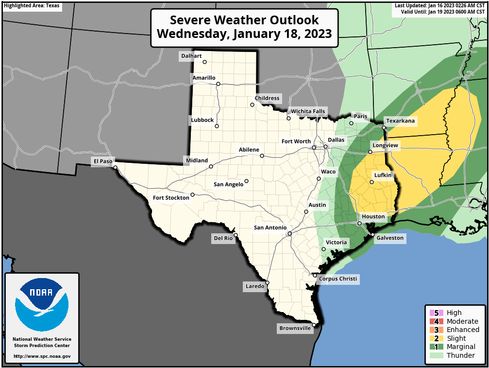
This will be another warm-ish day ahead of the next cold front, with mostly cloudy skies and high temperatures in the upper 70s. We’ll also see a decent chance of rain, especially during the afternoon hours, just ahead of the front. There is a slight chance of thunderstorms and severe weather, but conditions are more favorable to the east and northeast of Houston. The front itself will probably arrive during the afternoon or evening hours, clearing skies and driving lows down to around 50 degrees.
Thursday and Friday
These have the look of pleasant days, with highs in the 60s and partly to mostly sunny skies. Lows will be in the low 50s in Houston, with cooler conditions inland.
Saturday and Sunday
The first half of the weekend looks wet with the onshore flow returning, and highs in the low 60s. I don’t expect anything too crazy, but a few tenths of an inch of rain looks possible, with a few thunderstorms. A reinforcing front arrives Saturday night to bring us more dry air. Sunday will see highs in the low 60s, therefore, with overnight lows dropping into the 40s.
Next week
There are some hints in the models of a stronger front arriving on Tuesday or so of next week, which could lead to overnight lows in the 30s, and possibly even a light freeze. I have very low confidence in such an outcome at this point, but I’ll take a deeper look tomorrow as I know some of you are already wondering whether Houston has had its last freeze of the 2022-2023 winter. All I can say is that, right now, it’s far too early to make any definitive statements.


80 degrees in January should be illegal. Get the legislature on it while they are still in session.
I just finished shoveling my decks and driveway, I respectfully disagree about 80 degrees in January.
it does get cold in the south, never always warm stranger
Mark my words. I predict that Bush Airport will record at least one night/ morning of temperatures of 32° Fahrenheit or lower before March 1, 2023. It is just a guess.
Maybe, but I am guessing, just a guess mind you, that inside 610 and also toward the coast will not get below mid 30s again this winter. And, any temperatures at or below freezing at the airport will quickly warm above freezing. I mean, all the years I’ve been in Houston have had several winters that never got down to freezing at all.
I would guess that this will happen 11 days after I get brave enough to put my tomato seedlings in the ground. You know, just outside of the ten-day forecast.
As used by NOAA, what is the difference between ‘marginal’ and ‘slight’? I looked up ‘marginal’ in the Oxford dictionary and the first synonym listed is ‘slight’. If anything, I would put marginal above slight.
I’d put slight marginally above marginal.
Aren’t January/February historically the coldest months of the year for the Houston area? I never count out a quick dip below 32 in mid-late Feb.
Thanks for the super helpful forecasts. If I could make a suggestion to make it even better: on rushed mornings, readers may not have a chance to peruse the forecast in a leisurely manner. Would it be possible to add (maybe right by the day) a quick 2 second forecast summary? Like
Monday: H 78, L 47, windy but no rain
Just use a weather app if all you want are the quick stats. AccuWeather is a good one.
Just use a weather app if you want the stats only. AccuWeather is a good one.
Ha. Who in the world is asking if “winter is over” on January 16. Maybe by President’s Day that’s a good question. We’ve been plenty cool — not freezing — at the start of Spring Break in past years. We need to enjoy the 75 degree days but know “it’s not over”
I say it would be alot easier if you didn’t have ur nosed covered up you would be able to tell if it was cold hot warm windy wet are just damm right feed up with bullshit that you can’t even get to the places you need to be because you’re not digging the wind out the crack of your ass but someone’s nose latter Crash/_. ,. / ,😭🤪🤔🌏🌎🌍🌍🌎🌏🥑