Hobby Airport has started December with back to back 80 degree days, and there could be more to come. The last time we did back to back 80s in December was in 2019. We also accomplished the feat in 2016, 2015, 2013, and 2012, so it’s not super abnormal. Whatever the case, this is quite a departure from when I last wrote in this space a week ago and we had multiple European model ensemble members depicting 30s for lows in Houston this weekend. You can forget that. Let’s talk about what we can expect.
Today
Look for more fog this morning that should again lift by mid-morning in most spots. Dense Fog Advisories are posted around the region, but the fog is a bit spotty. It appears Brazoria County has some dense, as may parts of Montgomery County. The Beaumont/Port Arthur area is also seeing dense fog. Everyone else seems to be fine or seeing lighter fog. But you may run into some patches of dense fog as you maneuver around the area this morning.

Once the fog lifts, we will be left with a mix of clouds and sun this afternoon, as highs again make a run for 80 degrees. One of the differences between yesterday and today is that we could see a couple sprinkles or showers as a weak disturbance passes by. It may be enough to wet the ground in a few spots, but that’s about all.
Weekend
Saturday will see any morning fog lift once again, leading to a partly to mostly sunny day. A few showers can’t be ruled out Saturday afternoon, but those would be the exception, not the rule. Look for highs in the upper-70s to around 80 degrees after a warm morning in the mid-60s.
Look for mostly the same on Sunday, except it may be more like partly to mostly cloudy. Again, a slight chance of showers will exist, but nothing you need to change plans for I don’t think. Another morning in the mid-60s or warmer will transition to an afternoon in the upper-70s to 80 degrees or so.
Monday
Here’s where some intrigue begins. A cold front should actually press through the region early in the day. We will probably start the day well into the 60s in most spots, and then when the front passes through we will see temps hold or drop a bit. So 80 degrees probably isn’t in the cards for Monday.
Instead, expect a period of morning showers and storms, then cooler, breezy weather in the afternoon. Temperatures should drop into the 50s on Monday night.
Tuesday and beyond
Offshore winds are going to flip around and become onshore winds quickly late Monday night and Tuesday, leading to a substantial increase in moisture. Beyond that, we could be entering a bit of an active period of weather with showers, storms, and even some strong storms in the area ahead of another cold front. This would be most likely later Tuesday or Wednesday. Cooler air would settle in late next week but probably again for only a couple days. By next Saturday, the GFS Ensemble mean already has an over 90% chance that temperature anomalies will be at least 10 degrees warmer than normal.
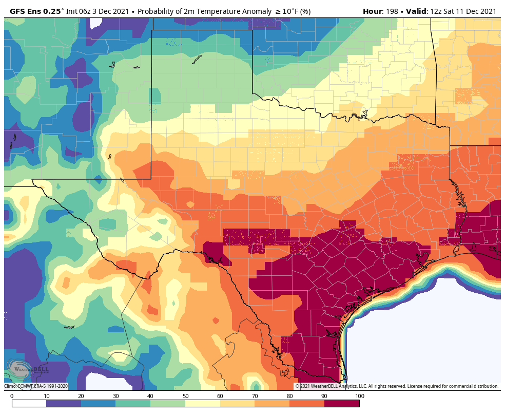
This means that of the 30+ GFS ensemble members, almost all of them see much above normal temperatures again next weekend.
The Arctic Oscillation
I’m going to take you more under the hood about things right now. Meteorologists use numerous tools to make forecasts. One of those tools is called “teleconnections.” We don’t often talk about those here in an effort not to bore you, but I think it’s instructive today and can explain some of why December looks to be so much different than how autumn has been for the last month or so.
Teleconnections are ways of explaining that because one thing happened in one place, there’s more predictability that something else could happen in another place. In other words, if you have a certain pattern over Alaska, that can often teleconnect to a certain pattern downstream over the continental United States. There are numerous teleconnections we can use, but one of the most useful ones is called the “Arctic Oscillation,” or AO. You can read more about the AO here if you’d like. The simplest explanation? As the AO trends more positive, this indicates a stronger polar vortex, one that’s more likely to stay near the North Pole where it belongs. We typically lean milder in those scenarios with most cold remaining in the high latitudes. If the AO flips significantly negative it can mean the polar vortex has weakened and is more likely to allow chunks of cold to travel south toward the mid-latitudes where more people live. For example, just ahead of the massive February freeze last winter, the AO got as low as -5, which was one of the most negative values of this index recorded since 1950. That did not cause us to get super cold here in Texas, but you bet it helped explain why.
So, why am I telling you about this? Well, if you look at a forecast of the AO Index for the next 2 weeks, what stands out?
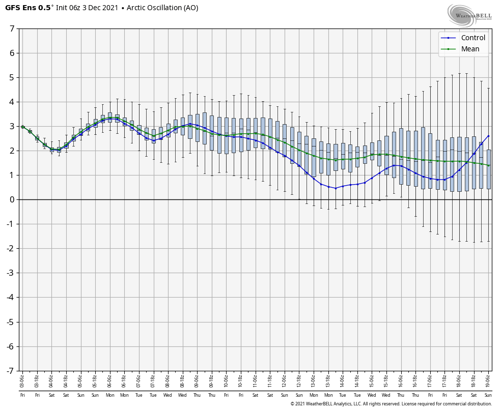
It’s raging positive (green line). We are frequently forecast to be at or above +2, with some ensemble members getting as strong as +4 to +5 at times. While this doesn’t guarantee that we’re going to stay warm deep into December, it sure skews the odds that way. No single teleconnection is a magic bullet in meteorology, but they serve as pieces to a larger, complex puzzle we try to solve each day. Today, this one stands out as one that will have an outsized influence on our December weather, so I thought it would be a good time to explain this to you. Hopefully it’s insightful! Enjoy the weekend.
“While this doesn’t guarantee that we’re going to stay warm deep into December, it sure skews the odds that way.”
Laaaaaaaaaaaaaaaaaaaaaaaaaaaaaaaaaaaaaaaaaame
I loved this post!! You explain things in lay terms so well. Thank you for taking the extra time to do that!
Thanks for the weather lesson. Keep up the good work.
Thanks for the AO link…I enjoy looking under hood!
I echo lee with LAAAAAAAAAAAAAAAAAAAAAAAAAAAAAAAAAAAAAAAAAAAAAAAAAAAME. And add gross to that. Thanks for the insight! I’ll be saving my cocoa bombs for January, I guess.
Thanks for the Arctic Oscillation lesson. It’s very informative. Maybe you guys could plan on having a similar shallow dive into various weather related items each Friday, or twice a week. I know you do it occasionally, and I feel like I get a little smarter each time.
Thanks for the explanation. It is helpful and interesting.
Thanks for the mini lesson. If yall ever think about doing a series of posts, I would like to read more about the forecasting process and the tools like AO yall use.
The weather lesson was great. I am trying toi learn more about the general weather mechanisms that influence our weather. It would be nice if there was a way to link to a page where such lessons are indexed.
Thanks!
Nuggets like that is why I read your forecast every day. I love to understand why some of this weather. Thanks again for all your great work.
It is interesting to see the box plots get wider the further into the future you go, reflecting the dynamical models used in weather forecasting. Nice real world application!
Also: I don’t know about other places, but I think the fog has been responsible for crashes on I-45 Southbound between Huntsville and Willis three days this week.
Enjoyed the forecast and the info on the Arctic Ossilation. Hoping for. No negatives like last year. Thanks!
Love the weather nerd stuff!
Very interesting! I had never heard of “AO”. I just really like learning something new everyday and your information was the first of the morning for me. Thank You!!!
Am I the only one that loves the warmer weather? I hate the cold with a passion. 😂
You are not the only one.
Only 107 days until Spring!
I mean.. I don’t want it freezing, but I do like cool December weather. Nobody wants to put out Christmas decorations be sweating like crazy.
Sometimes we go from summer straight into winter, but this season we’ve had a lot of fine autumn days. I think the relatively warm temperatures might also help us from getting an early wave of some virus or other.
Instead of “teleconnections” why not use the far more useful term “butterfly effect?”
This is not only not “not abnormal” but rather it is deranged because if climate change.
Perhaps “not abnormal” in a time is global heating causing climate crisis with no letup in sight on burning the fossil fuels candle at five ends in … but this “not abnormal” is a sign of crisis. Be honest about it.
Praise for mild November’s and December’s but let’s face facts. Using longitudinal tables, when was the last time Hobby reported back to back 80 December days sat, in the 1940s or 1980s or 1920s or 1960s? Of ever?
RE: Hobby Airport has started December with back to back 80 degree days, and there could be more to come. The last time we did back to back 80s in December was in 2019. We also accomplished the feat in 2016, 2015, 2013, and 2012, so it’s not super abnormal.
Before the climate alarmist get all excited, should you not mention the La Nina off the West Coast? It’s formation was predicted by meteorologist in October along with the effects that are currently playing out – warmer than average Temps in the southern half of the country. Just like last year’s La Nina.