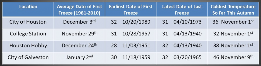
Before getting into the weather for this week, here’s a quick word in response to a question we’re getting a lot recently: Will there be any more freezes? I know it’s a question on your mind because I’ve been asked here, via email, and on Twitter, and Facebook during the last 24 hours. The answer is probably not; but not definitively not. Most of the Houston region has now passed the “average” date of its last freeze, so the odds of seeing freezing temperatures are less than 50 percent. However, the region has recorded freezes as late as April (see chart below).
With that said, I think the chances of seeing a freeze again this winter are low. While our weather will turn quite a bit colder from Friday through the middle of next week, it’s very likely not going to freeze in the metro area (College Station is another story, and could see a light freeze Friday morning). So we probably are safe through the first few days of March without a freeze. At that point the historical odds of a freeze fall below one-in-four. As is often the case with weather, our answer is probabilistic. In all likelihood, it’s not going to freeze at your house again this season, especially if you’re on the Gulf side of Interstate 10. But we’re not offering any money-back guarantees.
Tuesday
Today will be similar to Monday, with mostly overcast skies and temperatures nudging up into the low- to mid-80s. Winds will be out of the south, and gusty at times, perhaps reaching 25 mph. Some very light, misty rain will be possible, but overall chances are fairly low. Tonight will be cloudy, with lows dropping into the mid-60s.
Wednesday
In Monday’s post we discussed how the first front this week, arriving on Wednesday, was likely to stall out somewhere across the northern part of the Houston region. Well, things change. Now it appears as though the front will make a deeper push into Houston. Effectively this means that Tuesday will probably be the last really warm day this week as I now think the cold front will push all the way to the coast on Wednesday morning. If this happens, most of Houston away from the coast should wake up in the 40s or 50s on Wednesday, with daily highs only getting into the 60s. There is about a 50 percent chance of light rain during the day, but we don’t expect any meaningful accumulations.
Thursday
Our forecast continues to be uncertain for Thursday. While I think the bulk of the region will continue to see cooler air and cloudy skies, there is a non-zero chance that the front lifts back north and coastal areas see warmer and more muggy weather. However, for now I think most of Houston sees highs in the 60s, with more clouds and chances for misty to light precipitation. A reinforcing front should arrive on Thursday and push much further into the Gulf of Mexico, with lows dropping into the upper 30s for inland parts of Houston and lower 40s closer to the coast.
Friday
We’re confident that the entire region will be cold by Friday morning, with daytime highs likely topping out in the 50s, and another chilly night in the 40s for most. Skies will remain cloudy with a slight chance of light rain.
Saturday, Sunday, and beyond
Saturday will see more cool and cloudy weather, with highs in the 50s to lower 60s, and a chance of light rain. Sunday should finally see the return of partly sunny skies, and highs perhaps in the low 60s. Rain chances should be gone by then. Most of next week looks to yield partly sunny days with highs in the 60s, and lows in the 40s. This could be the last extended stretch of winter-like weather for our region, so if that’s your jam, be sure and enjoy it.
Just need the cooler air to hang on through The Woodlands marathon on the 5th. 🤞🤞🤞
Standard Rodeo Cookoff weather!
Thanks for all you do!
Do you still Tues 3/1 in Galveston will be 60 hi and 40 low & windy?
Of course it will be cold for the trail riders, the parade and cook-off for rodeo time
Well, it is better to be a little cooler (you can always put on more clothes) than too hot (at some point, you’ll get arrested if you take off too many clothes).
Plus, we’ll have summer heat in spades soon enough. While I don’t want it to freeze, I’d like the cooler weather to persist through the end of March.
Agreed.
Cooler weather is my “jam” so I will enjoy the next couple of weeks!
I don’t understand the far right column on your chart this morning. It references coldest temp so far this Autumn. I think I remember colder temps in January or earlier this month for each of the locations. So what is the significance/purpose of that far right column in relation to your observations on whether we’ve seen our last freeze? Thanks.
I wondered the same. I suspect he re-used an old chart, focusing on the “last freeze” date, and did not notice that the far right column was specific to the chart’s original context.
Get this cold weather out of here!
Can you provide any info on spring tornados. I know you can’t predict them, but historically we seem to have tornados in the March-April time frame. I was asking because I don’t want to put up my canopy until that time frame has passed.
Any insight would be appreciated. For the record I am in the Katy/ Cypress area, east of 99.
Our cheer team is driving to Dallas Thursday for a big competition (1400+ tams). Can you give some insight on driving conditions?