Good morning. It’s the winter solstice, meaning today is the shortest day of the year in the northern hemisphere. For Houston, that means 10 hours, and 14 minutes of daylight, compared the longest day of 14 hours, 3 minutes in June. The further north you go, of course, the more extreme the differences become. Beginning tomorrow, days will gradually lengthen until the summer solstice.
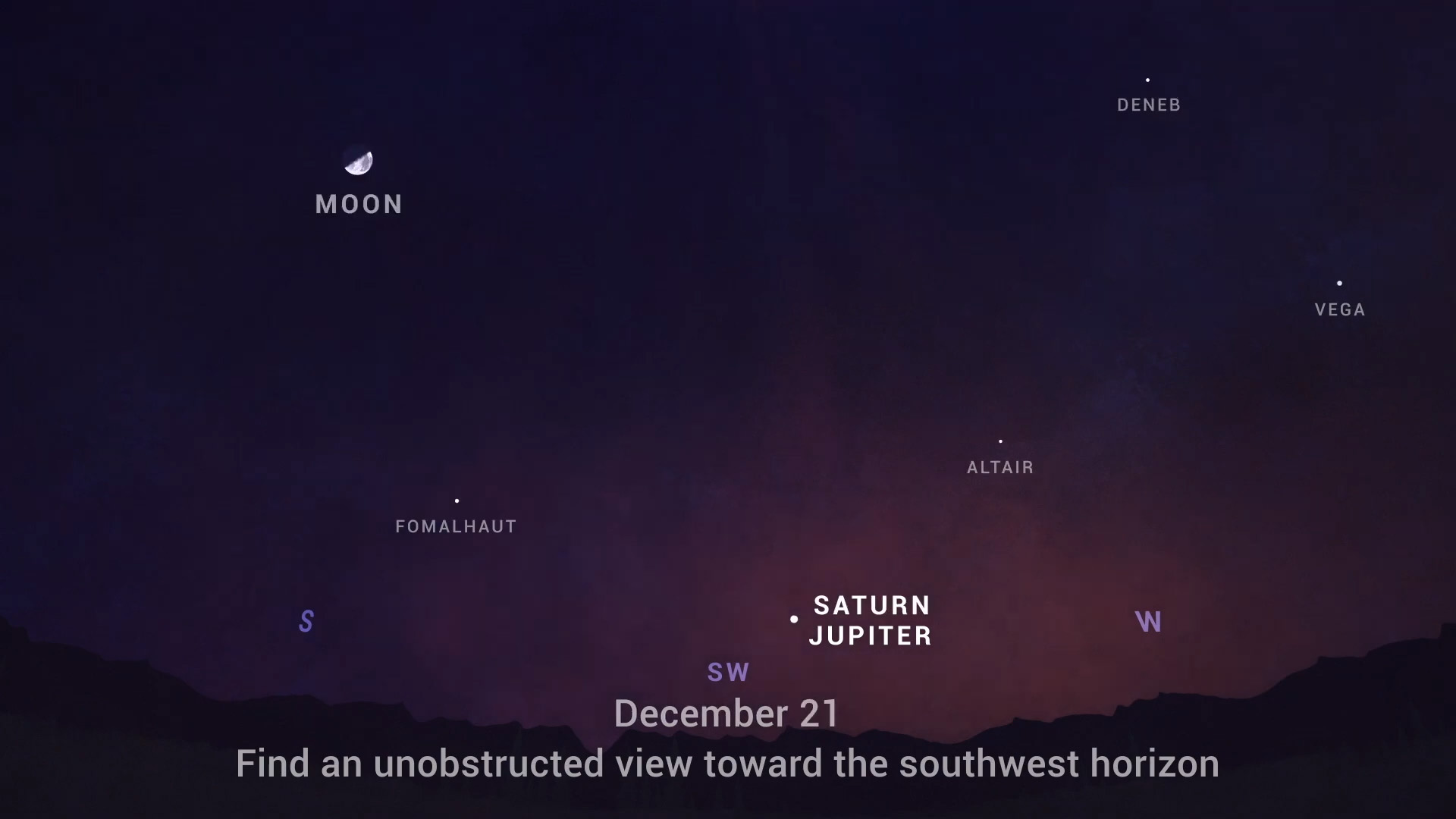
The shortest day also means the longest night—and this year there is a treat. Tonight Jupiter and Saturn will be making their closest observable conjunction in the night sky since the year 1226. This should be visible from most of Houston, despite the city’s bright lights. All one needs to do is go outside about an hour after sunset, around 6:30 pm. Find a clear view of the southwest horizon and look for the brightest object in the sky aside from the Moon. This will be Jupiter, and Saturn will be the fainter object next to it. These are the two largest planets in the Solar System, and although they appear in close proximity, they’re actually 456 million miles apart. Houston should hopefully have partly clear skies this evening.
Monday
Visibility across much of the area is good this morning, but fairly dense fog has developed right along the coast. It should dissipate by 9 am or so. As the high pressure that dominated Houston’s weather on Sunday moves off to the east, we’ll see winds turn to come from the south. This should allow temperatures to climb into the mid- to upper-60s later today beneath mostly sunny skies. Clouds will form tonight, likely keeping lows to around 50 degrees for much of Houston—although it will be cooler inland. Some fog may again develop early on Tuesday.
Tuesday
This will be another day like Monday, with mostly sunny skies after fog in the morning, and highs pushing up toward 70 degrees. Winds will be out of the south to southeast at 5 to 10 mph. Lows Tuesday night will be fairly warm for December, only falling into the upper 50s for most areas.
Wednesday
This will be the warmest day of the week, as our southerly flow continues. Despite partly cloudy skies, highs will get into the mid-70s. That will change later in the day as a cold front approaches, and passes through the region. Although confidence in the front’s timing is not absolute, we expect it to push through western areas during the afternoon hours, and off the coast during the evening. Some brief, light rain will be possible, but I don’t expect accumulations of more than a tenth of an inch, or two, for most areas. Lows Wednesday night will drop to about 40 degrees in Houston.
Christmas Eve
This will be a cold and windy day. Most of the area should see winds gusting into the 30s on Wednesday evening into Thursday morning. Winds will slowly back down during the day, but will still be noticeable. With highs only rising into the 50s, despite sunny skies, it will feel chilly outside. Throughout the day we’re going to see very dry air moving into the region, and dewpoints are going to crash. This will set the stage for a cold night, with lows dropping into the 30s for all areas but the coast.
Christmas Day
As a result of this, Christmas Day will start out cold. Skies should be partly to mostly sunny, however, and temperatures should warm to about 60 degrees for much of the area. It will be another chilly night, but most of the area stays in the 40s this time, probably.
Saturday and Sunday
The weekend should see a warming trend, with highs in the 60s, to possibly 70 degrees, by Sunday. Skies should be partly sunny. Another front may arrive Sunday night.
Between the Jupiter-Saturn conjunction tonight, warm days through Wednesday, then cold Christmas Eve and Christmas, this holiday week forecast is a pretty nice blend.
Continued thanks to Eric, Matt, and the webmaster!
I should have looked it up before hitting “post” but the webmaster’s name is Lee. Thanks to Lee, too!
Thank You and lets look for a great year in 2021. Prayer works wonders.
Hey guys, do you think you can work your weather magic and bring us a white Christmas???😊
No!!
Whats with all the contrails today?
if we can’t get outside at 6:30, how long do we have to catch the event?
I’ve read about 2 hours after sunset, so it should be visible, depending on physical ground obstacles and cloud cover, until around 7:30 this evening.
I’m glad it’s 70 today. I’d rather the dewpoint be 70 but I’ll take what I can get this winter. Sacramento is 40 at noon right now, so this is worlds better than there. Also I’m glad most of the holiday cold air is missing us to the East. It seems the Xmas cold snap won’t be as bad as the one last week.
I’m getting more used to winter and at least acknowledge the bug situation is sooooooo much better than in the summer. Plz no ice storms or anything colder than 30 at night tho and it should be good this winter.
Hi we are trying to be good and have an OUTDOOR family gathering for Christmas. Wednesday looks better than Thursday. What time Wednesday? ☺️