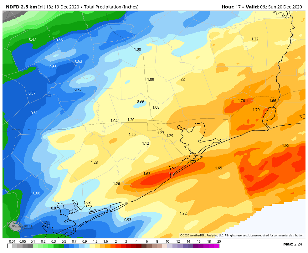
Just a quick Saturday update to say the latest forecast modeling suggests rainfall later today could be a bit stronger than anticipated. At this point we think much of the region may see 1 to 2 inches of rainfall, with the possibility of 3 inches for areas south and east of Harris County. Some minor street flooding may briefly occur.
In terms of timing, we expect rainfall chances to increase as the morning progresses, with a band of storms forming west of Houston shortly before noon and moving eastward. This band of storms should be near or off the coast by around 4pm this afternoon. A cold front will sweep through behind this band, rapidly bringing an end to the storm activity. We still anticipate mostly sunny conditions on Sunday, with highs in the mid-60s.
Looking further ahead, Christmas Day still looks quite cold. We will of course have a comprehensive update for you on Monday morning.

Good thing I gotta couple of umbrellas being shipped to me woth some SCW logos on them!
Rain’s coming down pretty good right now in League City, yeah.
Thanks Eric for taking time this morning with update…stay safe,..stay healthy…stay upbeat!
It was Mild and humid last night with a very comfortable 58 F. That’s a big improvement from the previous nights. Seems like today may see some thunderstorms.
Still sucks that Xmas is going to be cold but the next few days should at least be milder than it has been. That cold earlier this week was a real taste of the bitter side of Houston’s winter.
Earlier this morning the weather radar only showed very light precipitation anywhere near me. Of course, when I got about a mile from the house on my walk, it started pouring so I headed back home. Then of course it stopped raining completely when I was a 1/4 mile away from home.
Such is life in Houston.
Looks like good, solid Berger winter weather for Christmas. 😉
All the best to y’all and to the Lanza family and thanks for holding our worried hands through yet another interesting weather year!
So happy to get real weather reports now that our daughter introduced us to Space City.