With a fine, quiet stretch of weather beginning today for Houston, Eric and I thought it would be a good time to write a bit about the new climate normals released by NOAA on Monday night. When we compare weather to “normal” or “average,” these are the values we are comparing to, so it is useful to understand how they will be changing.
What are they? Every 10 years, NOAA and the National Weather Service, along with other government weather agencies around the globe recalculate what the typical weather has been like in the previous 30 years. Think of it like the Census, but for weather.
Why average 30 years of weather instead of, say, 50 or something? First off, the World Meteorological Organization (WMO), which is essentially the U.N. for meteorological agencies stipulates that member states use a 30 year standard. In general, 30 years is enough data to get you a good snapshot of what the current climate is, rather than a 50 or 100 year average. In other words, when we compare weather to a 30-year normal by saying something like, “Today was 15 degrees warmer than normal,” we’re comparing to the shorter-term climate we’re used to, not the one perhaps our grandparents lived through. And 30 values is generally when statistical averages become more reliable. Some users and industries prefer their “normal” to be calculated over a different timespan, so those calculations will be added to the mix from NOAA as well.
Why do they matter? When dealing with weather and making plans in business or designing buildings or planting crops, you need to have a baseline to anchor yourself to, some kind of “average” weather. Imperfect as they may be, the 30-year normals accomplish that. Having those allows us to explain weather in terms of how typical or atypical it is on a particular day or in a particular month. One thing we all know: Weather changes and can be wild, and “normal” is really just an average of a bunch of various extremes. But we need to have that anchor point to describe weather in a climatological context. I don’t know if this is originally attributable to him, but as Dr. J. Marshall Shepherd, former president of the American Meteorological Society likes to say: “Weather is your mood and climate is your personality.” It’s good to know a local area’s “personality!”
So what has changed? Let’s start big and then go small. Across the U.S., the new set of climatological normals is generally warmer, much warmer. The only areas cooler than the previous set of normals were in the Plains.
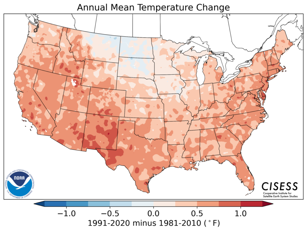
Officially, Houston’s annual average temperature (at IAH Bush Airport) rose by 0.7° versus the previous normal. At Hobby Airport that change was 1.0° warmer, and at Galveston it was 1.1° warmer.
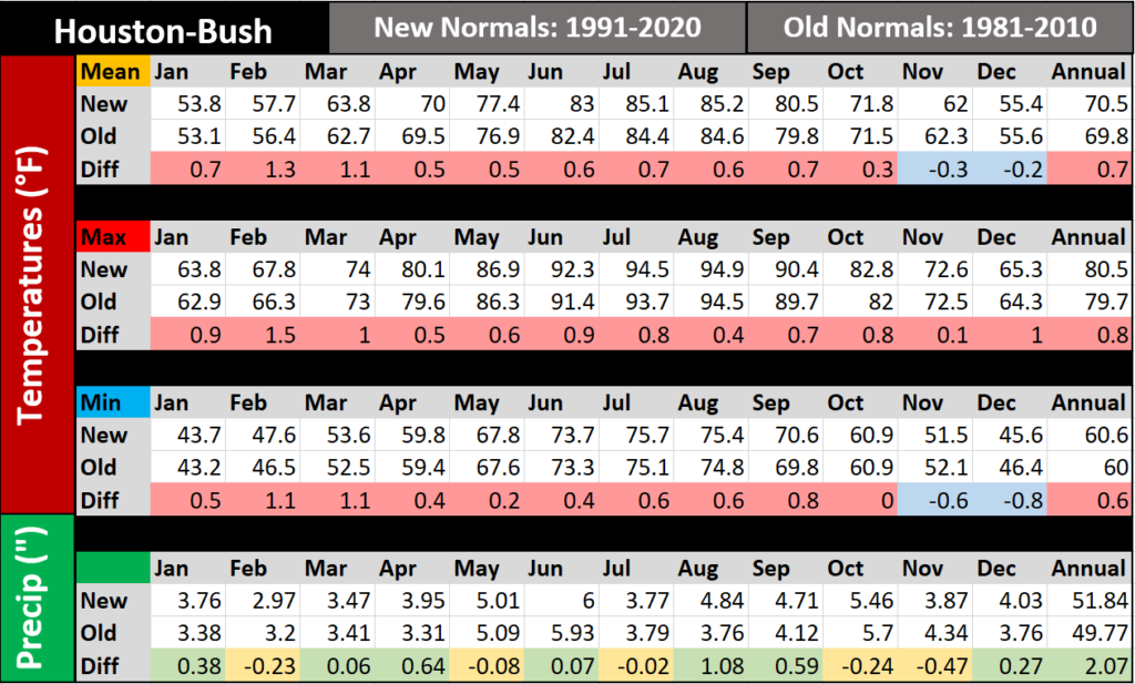
The only months that showed cooling relative to the previous set of normals were November and December. Summers have warmed by a bit over a half-degree on average, and late winters have warmed by over 1 degree. Some other notes: Our first day with an “average” high of 90° has moved up to May 29th from June 3rd. Our last day of average highs of 90° or better is September 18th, up from the 14th. So, we’ve added roughly a week more of days with an average high of 90° in 1991-2020 versus 1981-2010. Additionally our hottest daily average maximum temperature (or “peak” of summer) is up to 95.7° compared to 95.0° in the previous set of normals. Not only that, that peak has moved up a bit to August 4-6 versus a longer, flatter peak from August 5-12 previously. I wouldn’t read too much into that last part, but it’s something to note at least.
You’ll also notice that rainfall has increased, thanks in part to average August rainfall being over 1 inch wetter than in the prior normals. This is almost certainly thanks mostly to Hurricane Harvey. Houston now sees rainfall of roughly 2 inches more than we used to each year.
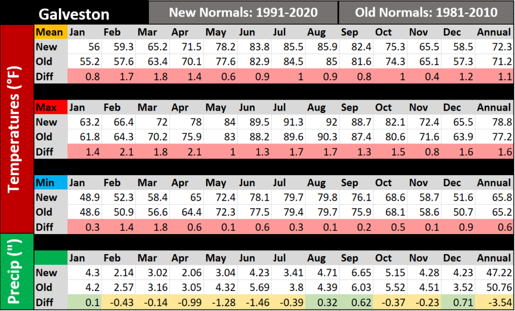
Interestingly, but perhaps not surprisingly to some folks if they live there, Galveston actually saw annual average rainfall decrease in this latest set of normals. In fact, not only does Galveston see less rain now on average, it’s over 3 and a half inches less! This is likely both a function of randomness in the sporadic nature of daily thunderstorms here but also a notable change related to <waves hands> something with respect to the warming water temperatures of the Gulf of Mexico or more frequent ridging in the upper atmosphere over the Southeast. This feels like too big a change to me to be just random chance. In addition, Galveston was substantially warmer, especially during nighttime. Average lows are over 1.5° warmer now than they used to be.
Anyway, hopefully you find this interesting. How we describe weather “relative to normal” will change going forward, so we feel it’s notable to explain to you how that will change. On to the forecast.
Today through Friday
Step outside this morning, folks.

We have temperatures in the 50s inland to low or mid-60s in the city and along the coast. And the humidity has plummeted. Look for plenty of sunshine and highs around 80° or in the low-80s this afternoon. Tomorrow looks just as nice. Expect morning lows in the 50s north and west of Houston and low or mid-60s in the city and along the bay. Galveston should see upper-60s. Another day of sunshine will allow us to get into the mid-80s tomorrow. Friday looks like essentially a carbon copy of Thursday with a few added higher clouds at times.
Saturday and Sunday
Look for onshore flow to kick back in this weekend, driving our dew point temperatures back up to 70° or so, along with highs well into the 80s. Saturday morning will probably see 60s for lows, while Sunday should see 70s in the morning. Along with that, there is at least a chance of a shower or storm Saturday. For Mother’s Day, we expect a slightly better chance of showers, however despite being better, those chances still remain fairly low right now in most of the Houston area. As you go north of Highway 105, the chance for some more robust rain and storms may increase somewhat. We’ll hone in on details more tomorrow and Friday.
Next week
It’s too early to get too into the weeds next week, but with a cold front “in the neighborhood,” suffice to say it will probably be a somewhat unsettled period ahead. More on this for you tomorrow and Friday as well.
I don’t have the bandwidth this morning to police the comments and remove abusive/uncivil stuff. Locking the discussion.
How does the 50-year average compare to the 30-year average? Does it show an increase or increase in temperature or is it flat? I agree that Harvey impacts Houston’s rainfall, but what if you take “one off” events and put in the average rainfall for that month? How big of a change is it?
I am highly cynical when it comes to changing statically methods for what was “standard” especially when it comes to weather and/or climate change. Predictions for catastrophic future climate events rarely if ever come about. Without the comparative data of 50 vs 30 year average to study, then I will believe that this change is part of the climate change narrative trying to convince us the earth is warming and will never stop warming. This ignores earth’s history and will not convince skeptics like me.
You folks do a great job for H’town and I really appreciate you daily posts. Keep up the splendid work.
Michael, here is a good article that will help you visualize the previous ~100 years of climate change over the US.
It’s been continuously warmer. Will warming continue? Most experts think so.
https://www.noaa.gov/news/new-us-climate-normals-are-here-what-do-they-tell-us-about-climate-change
I have read that there is increasing acceptance of the sun entering a grand solar minimum due to some recent computer modeling. It is claimed it could bring on extended cooling? Do you have any views on the credibility of such claims?
NASA says the solar minimum will not bring about lower temperatures, no.
I understand your skepticism, Michael. I don’t share it, but I get it. Whether you do or don’t believe climate change is happening and could lead to increasingly catastrophic events that we seem to be experiencing, I would believe regardless that we can ALL agree that we need to be much better stewards of our blue planet. Emissions need to be reduced – if not for the climate, then for our health. Ask a asthma sufferer. I’ll tell you personally. It behooves us to do the best we can to have a cleaner, greener climate and we owe it to our future to explore and institute alternative energies to augment fossil fuels. If you invest in stocks or funds, then you likely understand how important it is to diversify your portfolio. Why people scream about this is beyond me other than simply being Karens or working in the O&G sector, of which case, I do. But even my global O&G company knows better and is diversifying beyond O&G only.
Thank you for the great info! I have a question about rainfall. We used to regularly have big thunderstorms and rain for several days at a time in the summers. I haven’t been collecting data, but it seems like to me that since the drought in about 2005, we don’t get that summer rain. Also, we’re in the southwest metro area, and most of the rain seems to go north and east of us. Is this my imagination?
Well it stands to reason that if the country is getting wetter the more east you go, on a smaller scale perhaps, Eastern Houston is likely to be wetter than West Houston in 50 years? It’s always been the case that Beaumont is wetter than Houston. Their yearly rainfall average is almost 10 inches more than Houston. But individual events are always going to vary. Just last weekend, large parts of El Campo and Wharton received 10-15 inches of rain and parts of East Houston only got 1-2 inches.
Is there any data on the warming during the Ice Age?