Good morning. If you’ve come to read this in hopes of learning when Houston’s wet pattern will break, I’m afraid we’re going to disappoint you. The short answer is: Not any time soon. Houston is going to see daily rain chances through at least the middle of next week as our region remains open to Gulf moisture and rising air.
Thursday and Friday
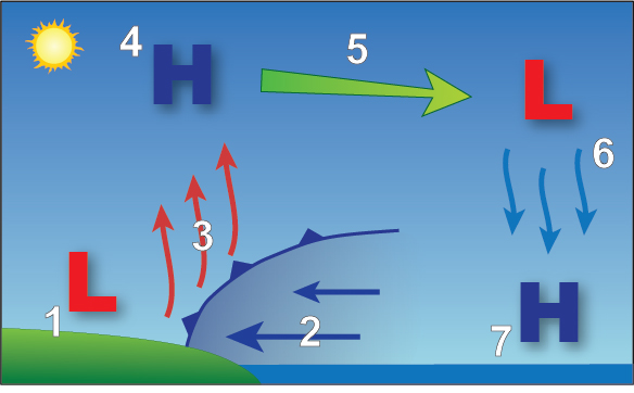
Our best-guess forecast for the next two days is that conditions will be a lot like we experienced on Tuesday and Wednesday. Effectively, this means we’re likely to see showers and thunderstorms develop closer to the coast during the late morning hours and then slowly migrate inland during the afternoon hours. These storms are driven as the sea breeze moves inland from the coast, and combines with warmer surface temperatures to lift moisture higher into the atmosphere where it can condense. You can learn more about the sea breeze, and how it affects our weather during the summer, here.
Anyway, these showers will be hit or miss, but some areas may pick up 1 to 2 inches of rain while nearby you just see gray skies and hear thunder. Highs will generally be limited to about 90 degrees with a mix of partly sunny skies. Winds should come out of the south at 5 to 10 mph.
Saturday and Sunday
The overall setup will not change this weekend, although it does look as though the moisture available for storms to develop will decrease slightly. This means there will probably be fewer showers and thunderstorms for you to dodge this weekend, but the threat is unfortunately not going to go away during the afternoon hours. Again, this activity should driven by the sea breeze. Highs will otherwise be in the low 90s for much of the area, with mostly sunny skies.
Next week
This pattern should persist into Monday, after which time we may see conditions actually become more favorable for rainfall on Tuesday and Wednesday. While the details are fuzzy, we can expect a low-pressure system to push rain chances higher into mid-week, and this should help to keep temperatures on the low side for our region, perhaps around 90 degrees.
Finally, by about Thursday or so, the models generally agree that our region should begin to see fewer showers and thunderstorms. But that is far enough into the forecast such that I don’t have too much confidence in such a prediction yet.
4.9″ here near Ellington yesterday. I didn’t realize I had moved to Seattle. Was supposed to be North Carolina.
Seattle’s average annual precipitation: 40″
Houston’s average annual precipitation: 52″
You may have been misinformed 🙂
Beginning to notice that this summer has been quite a bit wetter than the last couple of summers we had.
This rain has helped keep the humidity down.
I have to say this is what I remember as a kid. Afternoon showers were always welcome to cool off the evening and make the day great. Beautiful sunsets, endless grass growth. This is Houston as it should be!
yes, this is what I remember, too. Except the storms didn’t make things necessarily better. The temperature might drop, but if the sun was still high when the clouds dissipated you had a steam bath.
Same. 80s Houston kid here and we had splashy afternoons that could go either way — cool down or steam bath. I remember a few times being caught in standing water just running errands and having to wait it out to drive home.
GROSSSSSSSSSSSSSSS 🙁
Thank you guys for putting it out like it was done 30-40 years ago, when a Weather Person just reported the news and added little or no hype. My hat to y’all.
TV WeatherWizards are not meteorologists; they are entertainers, whose sole job descriptor is to use tease after tease to keep you tuned in to the same station for 30 minutes and then to entertain you in between pestiferous incessant commercials with slices of weather information and knowing winks and nods to make you think you are buddies.
This became the norm in the 80s via expensive consultants hired to increase a local station market share —that was when emoting became the only function of on air talking head talent in news, weather and sports.
Space City Weather is a welcome, breathtaking departure from all that.
TV WeatherWizards are not meteorologists; they are entertainers, whose sole job descriptor is to use tease after tease to keep you tuned in to the same station for 30 minutes and then to entertain you in between pestiferous incessant commercials with slices of weather information and knowing winks and nods to make you think you are buddies.
This became the norm in the 80s via expensive consultants hired to increase a local station market share —that was when emoting became the only function of on air talking head talent in news, weather and sports.
Space City Weather is a breathtaking departure from all that.
Loving the rain! I hope it continues doing this until the end of September!
When I moved to Houston in 1990, this is the weather we had. Somewhere around 4-5pm, we would have thundershowers. Then it would all clear away. And the skies were clearer, the clouds with nice definition. This seems like the “normal” Houston weather to me.
I do not mind the rain. The summer of 2011 still lurks in my mind. Appreciate what you guys do!
On the good side, the rain is keeping the temps down and hopefully bleeding energy off the Gulf.
On the bad side, I’ve been waiting over a week to get my roof repaired so a brown spot on the ceiling doesn’t become a major leak. The rain that’s going on outside right now isn’t going to help that wait.
Thank you for your in depth weather analysis. I appreciate you!